Page 3 of 4
Re: Designing questions
Posted: Wed Oct 23, 2013 4:07 pm
by lesossies
Now I understand what you meaned.
http://www.radsportfreaks.de/radsport/p ... ension=c4f
...............radsportfreaks.de/radsport/popupdatei.php?rennen=
name of the race&extension=
c4f it should work with old
etn file too.
THX Pokemon
Re: Designing questions
Posted: Wed Oct 23, 2013 5:34 pm
by Hunsrueck
Thx Poke and Leso

....now i am happy
Re: Designing questions
Posted: Tue Dec 10, 2013 3:04 pm
by Vea Olio
I want to design a circuit race...but the circuit isn't good...there is a difference between the first passage in the circuit and the last...how I can resolve it??
Re: Designing questions
Posted: Tue Dec 10, 2013 3:33 pm
by olmania
Vea Olio wrote:I want to design a circuit race...but the circuit isn't good...there is a difference between the first passage in the circuit and the last...how I can resolve it??
You can adapt manually the % according to the profile you have with your designed road. The summit between positive and negative kms during this circuit should be 0.
If your circuit has a too big difference, you should reconsider its design, if it's just a little difference, you can adapt it manually in the stage editor, before "repeating" the lap with the editor

Re: Designing questions
Posted: Thu Jan 02, 2014 1:17 pm
by Hunsrueck
've got a question.
BikeRouteToaster and T4B does not work.
with what program created it your race and you could here a step by step manual adjust?
I have already tried with Google Maps, but I am too stupid for it

Re: Designing questions
Posted: Thu Jan 02, 2014 3:44 pm
by lesossies
Most of the time I use openrunner. It works very well and is continualy ameliorated.
The site:
http://www.openrunner.com/
Re: Designing questions
Posted: Thu Jan 02, 2014 5:08 pm
by Hunsrueck
lesossies wrote:Most of the time I use openrunner. It works very well and is continualy ameliorated.
The site:
http://www.openrunner.com/
thanks, I'll try. if I have questions I'll get back
Re: Designing questions
Posted: Tue Oct 11, 2016 4:40 pm
by cataracs
I can't find any of "RKL" races in show_races, where can I find them?

Re: Designing questions
Posted: Sun Oct 01, 2017 2:42 pm
by Pokemon Club
I just see that
https://www.la-flamme-rouge.eu/maps/editor open a part name "Race Calendar" where they put all races of the season. Can see the road, the profil and download the gpx of the races.

- Capture.PNG (62.9 KiB) Viewed 6126 times
Re: Designing questions
Posted: Thu Oct 05, 2017 5:28 pm
by RS Coesitz
First: I have a problem with the stage designer. I want to draw a tour in Israel as December Tour. I do it with
http://www.bikehike.co.uk/mapview.php and then GPS-Track-Analyse. All in all it works, but the maps get imprecise.
For example when I take this route as prologue:
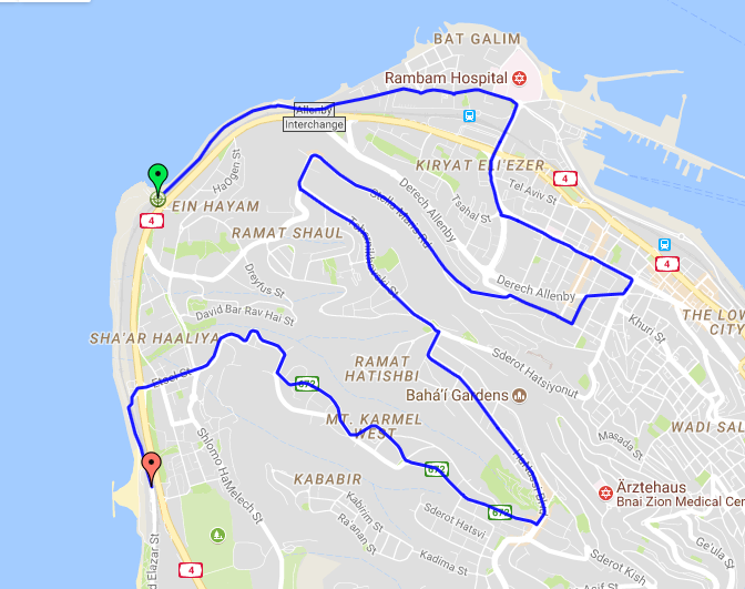
it looks like this after I was putting it into the RSF-Editor:
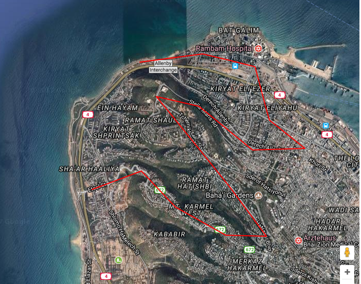
There are lots of shortcuts and it´s not the real route. What can I do?
Second: How can I input half-stages at the Editor, I want the race to be 01a and directly followed by a short 01b stage.
Third: Where can I find my saved files?
Thanks!
Re: Designing questions
Posted: Thu Oct 05, 2017 6:37 pm
by Robyklebt
The track is ok. On the RSF map it shows only every km, not all the track points in between. So that's the way it's supposed to be. It doesn't show km 0 on the map either if I remember correctly, but don't worry about that. Track ok.
Half stages: Normally. Just keep counting. Stage 1a is stage 1, stage 1b is stage 2, stage 2 is stage 3 in the input field there.
Remember what you save them under, then oyu can re-load them on the top right, with the name + .c4f For example save stage 1 as "donkeyisgreat_1", then load it as "donkeyisgreat_1.c4f"
Even if you didn't ask: Use recalculate elevation to adjust the altitude gain etc. It's often pretty far off without adjustments.
All ohne Gewähr...
Re: Designing questions
Posted: Fri Oct 06, 2017 1:34 pm
by RS Coesitz
Robyklebt wrote:The track is ok. On the RSF map it shows only every km, not all the track points in between. So that's the way it's supposed to be. It doesn't show km 0 on the map either if I remember correctly, but don't worry about that. Track ok.
Half stages: Normally. Just keep counting. Stage 1a is stage 1, stage 1b is stage 2, stage 2 is stage 3 in the input field there.
Remember what you save them under, then oyu can re-load them on the top right, with the name + .c4f For example save stage 1 as "donkeyisgreat_1", then load it as "donkeyisgreat_1.c4f"
Even if you didn't ask: Use recalculate elevation to adjust the altitude gain etc. It's often pretty far off without adjustments.
All ohne Gewähr...
Thank you! I used recalculate elevation (just pushed the button) but have the feeling that nothing changed...
Re: Designing questions
Posted: Fri Oct 06, 2017 1:46 pm
by Robyklebt
No no, nothing changes automatically. But then it shows you the elevation of the track on the left, and the elevation in the game on the right. And you can adjust the percentages if necessary.
Re: Designing questions
Posted: Sun Oct 14, 2018 10:51 pm
by RS Coesitz
Anyone still using bikehike? Somehow it does not load googlemaps for me there...
Re: Designing questions
Posted: Sun Oct 14, 2018 11:12 pm
by luques
Use gpsies.com imo is much better
Re: Designing questions
Posted: Mon Oct 15, 2018 1:16 am
by Pokemon Club
RS Coesitz wrote: ↑Sun Oct 14, 2018 10:51 pm
Anyone still using bikehike? Somehow it does not load googlemaps for me there...
Google Maps increas a lot their price so all website (Flamme Rouge, openrunner, gpsies, bikehike,...) stop us it, too expensive
Re: Designing questions
Posted: Tue Nov 26, 2019 9:50 pm
by Hansa
didnt created races in years and dont really remember how it works and the links i used back then also dont work anymore. anyone can give me a crashcourse which sites i can use and how i import it in the rsf editor?
Re: Designing questions
Posted: Tue Nov 26, 2019 10:21 pm
by olmania
Re: Designing questions
Posted: Thu Sep 23, 2021 8:20 am
by flockmastoR
Hello I have a question about the C4F Stage Editor. What exactly is the purpose of the "Hills Amplification" option when uploading a gpx track? Is it some kind of correction for the elevation calculated? And is it recommended to use it. Have tested some things drawing the route of this years Lombardia and uploading without it makes quite a lot of error in the elevation over time (expect to be summations of rounding errors).
Whats the general workflow for races like this?
1) Draw the route
2) Upload to editor
3) Re-adjust climbs and final kms manually
Re: Designing questions
Posted: Thu Sep 23, 2021 9:11 am
by Robyklebt
Damn... Questions I know the answer to would be nice.
Hills amplification... never use it. Tested now: Difference seems to be:
1)It shows the calculated height immediately after upload.
2)It seems to come out more precise too, did a test with Sabatini, gets the right height at the end. Without "hills amplification" off 50 meters at the end. Hmmmm... Same with an old fantasy race, exact result with "hills amplification", 50 meters off at the end without. Another one precise with hills amplification, off 300 meters without.
Thanks! You are helpful, can we give you the title "advanced editor-teacher"?
Workflow correct. For real races though "drawing the race" nowadays is: Download the gpx from
https://www.la-flamme-rouge.eu/maps/races/calendar
or the site of the race sometimes.
Re: Designing questions
Posted: Thu Sep 23, 2021 10:12 am
by flockmastoR
Robyklebt wrote: ↑Thu Sep 23, 2021 9:11 am
Damn... Questions I know the answer to would be nice.
Hills amplification... never use it. Tested now: Difference seems to be:
1)It shows the calculated height immediately after upload.
2)It seems to come out more precise too, did a test with Sabatini, gets the right height at the end. Without "hills amplification" off 50 meters at the end. Hmmmm... Same with an old fantasy race, exact result with "hills amplification", 50 meters off at the end without. Another one precise with hills amplification, off 300 meters without.
Thanks! You are helpful, can we give you the title "advanced editor-teacher"?
Workflow correct. For real races though "drawing the race" nowadays is: Download the gpx from
https://www.la-flamme-rouge.eu/maps/races/calendar
or the site of the race sometimes.
You are welcome

Ok the flamme rouge thing is nice (despite the 1990s uglyness of the website). So the main designer job is to check the hills and decide if the 2-2-8 final climb is appropirate or if it is better to go with 2-3-7? I think because of averaging over full km way-points you might lose information and have to check from top backwards? Is that what you are doing in such cases?
Re: Designing questions
Posted: Thu Sep 23, 2021 4:25 pm
by Robyklebt
Yes, ideally check as much as possible then.
Check the website of the race for precise info about climbs in some cases (RCS races; Giro, Lombardia etc, have good infos on their site). If not but it looks strange draw yourself to doublecheck. From top or bottom, no idea, if it's the finish, yes, try to get the last km right... then probably from top. But adjust too, if the last km goes up 16 meters, so +2, but the last 500 meters are completely flat.... do a 1 or maybe even a 0 sprint.. stuff like that.
If there's cobbles look at google street view to assess or guess how hard it should be.
Re: Designing questions
Posted: Mon Oct 17, 2022 9:23 pm
by Hansa
I would offer some designen advice via Discord screensharing if anyone is interested.
We can meet in the discord and i can show some designing Stuff via the screenshare and we can talk about some tips and useful sites if anyone needs some help for starting their designing career and is interested.
Just write me a PM and ill invite you to Discord.
Re: Designing questions
Posted: Mon Feb 06, 2023 6:46 pm
by cataracs
What's the highest % that the game can support right now?
Re: Designing questions
Posted: Mon Feb 06, 2023 9:10 pm
by Alkworld
cataracs wrote: ↑Mon Feb 06, 2023 6:46 pm
What's the highest % that the game can support right now?
I don't think there's much of a limitation currently, but some calculations for high percentages become a bit weird, like following or siebing.