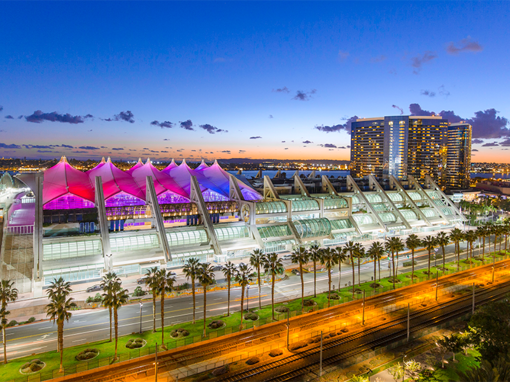
Tamil Nadu&Kerala International Bicycle Race
Our entry for this years December Tour is in c4f starved southern India. They really love c4f there, but never had a December Tour, wherever we went during our reconnaissance trips, we were immediately recognized, you're Big Donkey! Or RKL? The designer, please, bring the December Tour to us! So while originally we had already a rough plan for a December Tour in another place, this was more for future ideas, we decided to make Southern India happy immediately.
As almost always for RKL Dec tours, this one on paper is for a climber with TT. But we don't play on paper, so...
5 flat stages
3 middle mountain stages.
4 HC stages,
1 TT, with some hills.
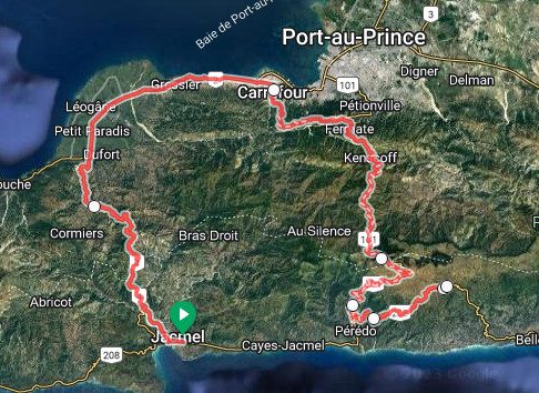
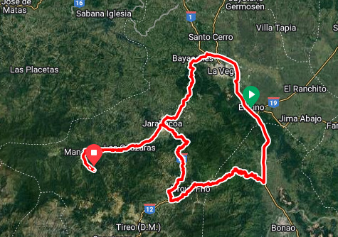
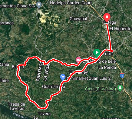
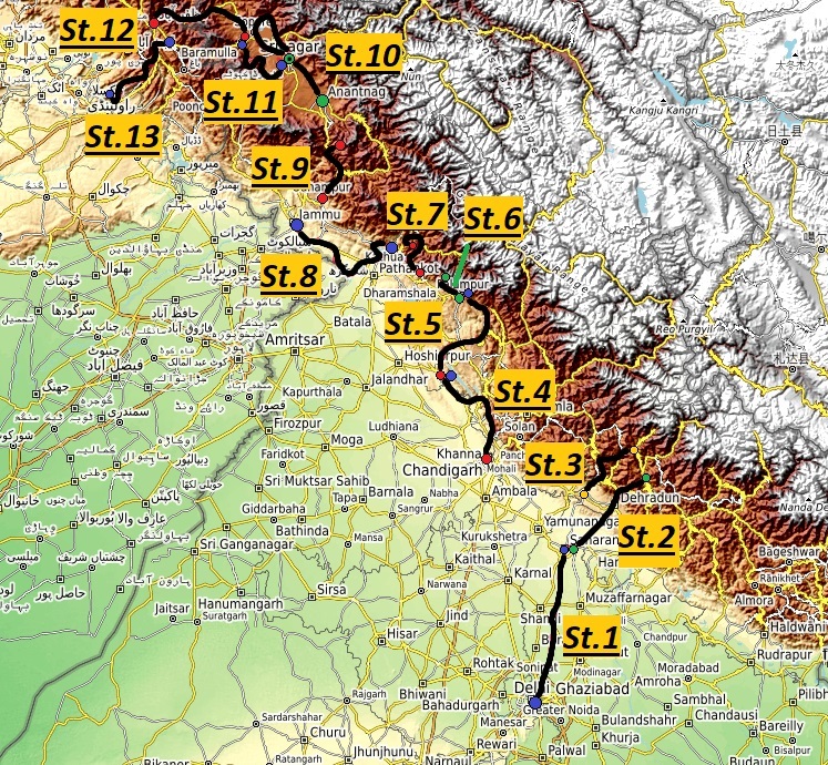
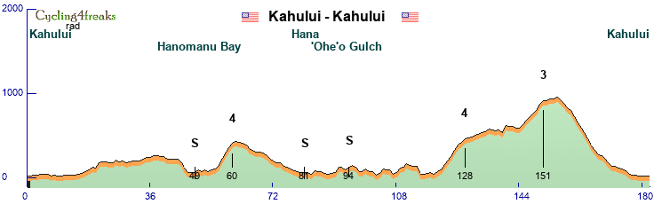
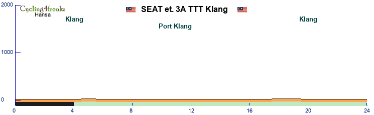
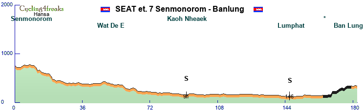
Here a map, as great as RKL is in desiging tours, his map creation skills need to be worked on. No numbers or anything, we start in the north east, Chennai, which isn't readable... bah. Black dots are transfers, you'll figure it out. Eventually.

9 riders
Mintact 30 km unless otherwise mentioned.
1 IS per stage
But let's go to the stages:
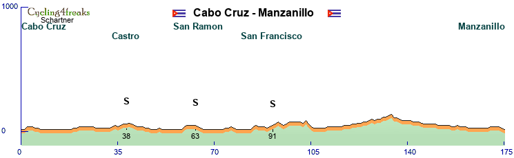
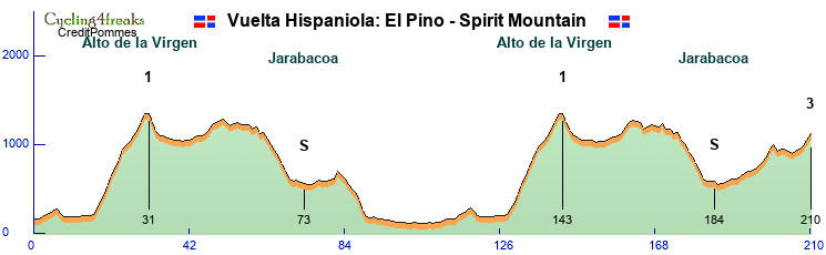
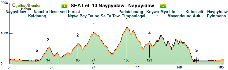
Stage 1 Chennai-Tiruvannamalai
190 km
Flat stage
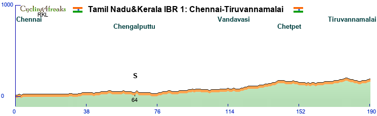
The start is in Chennai, from there we head southeast and reach Tiruvannamalai after 190 km.
A completely flat stage. Not much to say about it really, the finish is +1. No GPM, the steepest km is km 65 at 2%. That it, a flat stage.
So let's concentrate on Chennai and Tiruvannamalai instead.
Chennai, state capital and biggest city of Tamil Nadu, formerly known as Madras, nowadays a modern city, 12 millions inhabitants. One of the economic centers of India, the center of its automotive industry and strong IT technology too.
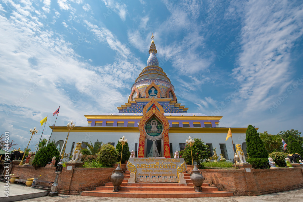
Tiruvannamalai is much smaller, the metro area has only 400'000 inhabitants. It lies at the foot of an isolated hill, Arunachala, and has a big temple complex, Arunachalesvara Temple.
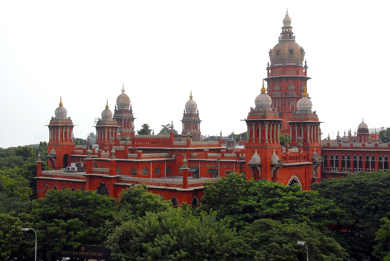
Madras High Court. An example of Indo-Saracen architecture, meaning combining Indian, more specifically Mughal architecture with western architecture. We'll pass close to the High Court in the first kms of the race. Actually around the first km.
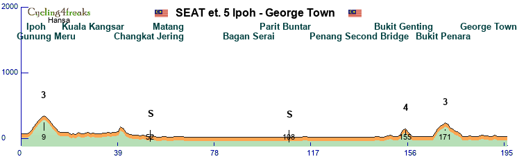
Stage 2: Tiruvannamalai-Salem
209 km
Hilly stage
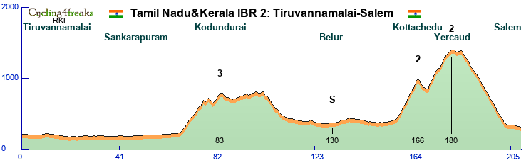
The first middle mountain stage. After 65 flat km, the first climb of the Tour. We enter the Kalvarayan Hills from the east, a longish but not too difficult climb, there's only 3 km at 6% or more. The real difficulties start later, at km 158, where we start the climb to the Shevaroy Hills, to Yercaud, located 1370 meters above sea level. The climb is in 2 steps the first 1 9 km to a village called Kottachedu 970 meters above sea level after a 4 km downhill we tackle the second part, another 10km up to Yercaud. but only 5 km are above 6%, it's 6 in the first step. On top, after 2 km at 3% we have a very short flat section, then the downhill followed by another flat km. This should clearly be too much flat for the climbers, so strong classics should get this one.
Not much to say about the finishing city, Salem, 5th largest urban agglomeration and 3rd largest metropolitan area in Tamil Nadu, but doesn't really seem to have any special attractions. Big textile industry, you can buy new jerseys for your team there I guess.
The Shevaroy Hills are used for recreation, cooler weather, so popular, but they don't seem especially picturesque, at least RKL couldn't find any convincing pictures on wikipedia (where for simplicity's sake he steals his pictures) Coffee and citrus fruits are grown up there.

The first of many temples, the Arunachalam temple in Tiruvannamalai mentioned in the presentation of stage 1. Although finally you won't get to see that many temples in this presentation.
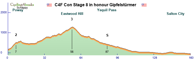
Stage 3: Salem-Top Sengattupatti
160 km
mountain stage
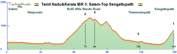
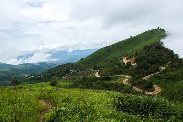
The first mountain stage, so we should get the third new leader today. The stage is not too difficult, but as an early mountain stage it's not supposed to decide the Tour. We head south from Salem and after a basically flat 54 km, the first difficulty of the day starts. The Kolli Hills Bend road. 70 hairpins up to 1200m above sea level, so almost 1000 meters altitude gain. But while the road is spectacular, it isn't overly difficult, we have only 4 km at 6% or more, it takes us 21 km for 950 meters altitude gain. We cross the Kolli Hills, go down north, head back south, and finish the stage in the Pachamalai Hills. This road has switchbacks too, 12 if we counted correctly, but is steeper, 9km, 540m altitude gain. 5 6 4 6 8 6 6 6 7. We'll finish in Top Sengattupatti, After today's stage the GC should already look slightly clearer, from now on the stage winner won't automatically be fighting for the leaders jersey anymore normally.

The 34th of 70 hairpin on the way to Solakkadu. As you can see it's not a very steep road, spectacular yes, mabe not this picture, look for better ones yourself.
Stage 4: Tiruchirappalli-Coimbatore
202 km
flat stage
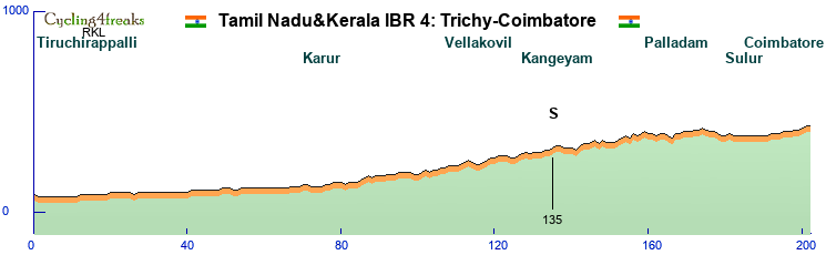
For the start of the 4th stage we move around 80 km south and start in in Trichy, as Tiruchirappalli is thankfully still often called. Tiruchirappalli would have made the name for the stage too long. Called Trichinopoly by the English during colonial times, the official name changed to Tiruchirappalli, but people usually refer to it as Trichy or Tiruchi. Most livable city in Tamil Nadu, close to 1 million inhabitants. Pretty much in the geographic center of Tamil Nadu. Famous for the Sri Ranganathaswamy Temple just outside the city and the Rock Fort, a fortified 3.8 billion years old rock with 2 temples in it/on it.
Coimbatore, the second largest city of Tamil Nadu is where we finish today. On the western edge of Tamil Nadu, with the western Ghats to the north and west. Textile industry, engineering.
Oh, the race? It's flat. We start at 70 meters and finish at 420 above sea level, last km is a 0. At 202 km it's another rather long sprint stage, but after recovering for 2 days the sprinter teams normally should be up for it. An important stage for the points jersey, not for the GC.
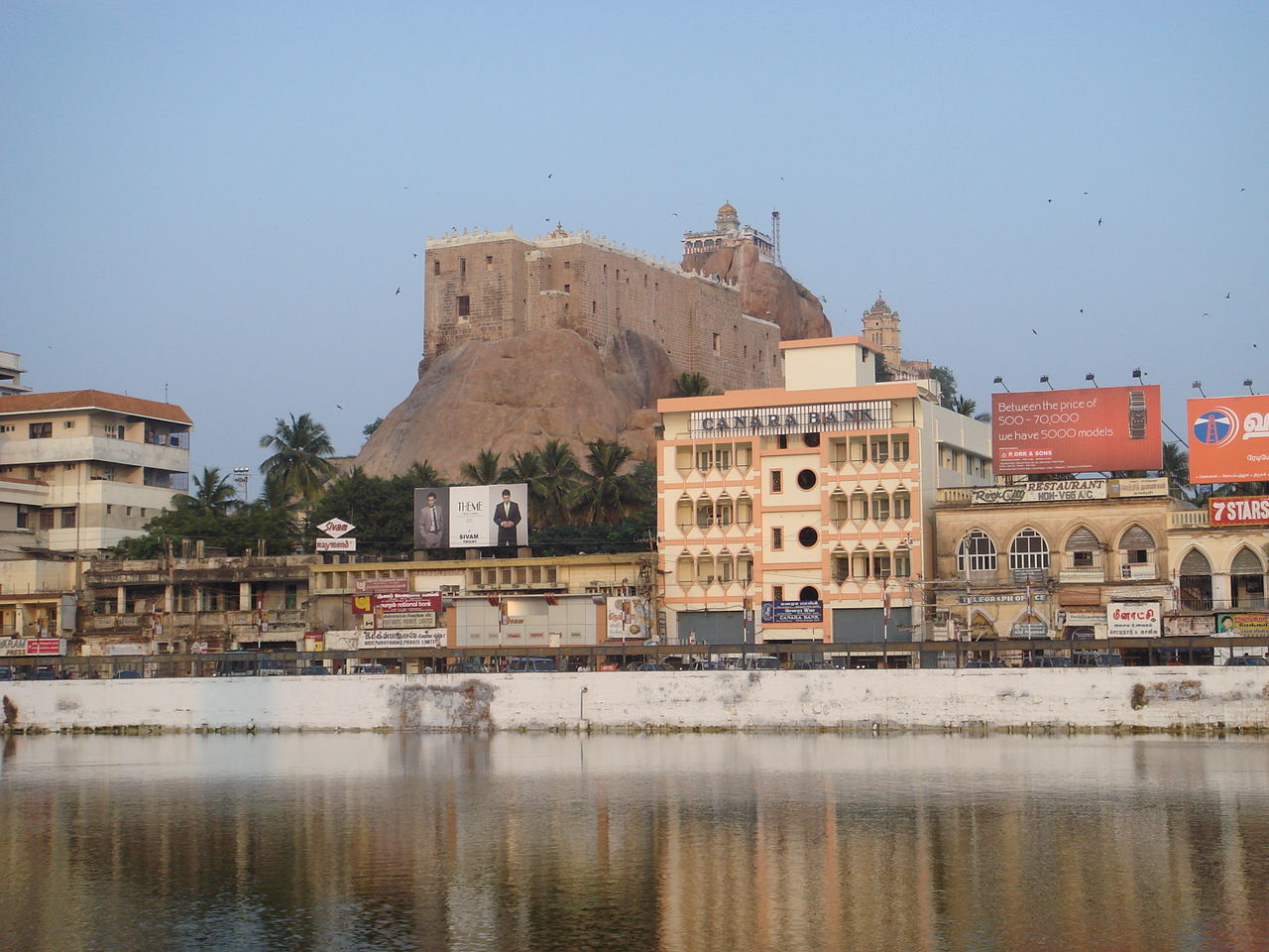
The rock fort in Trichy.
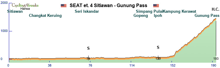
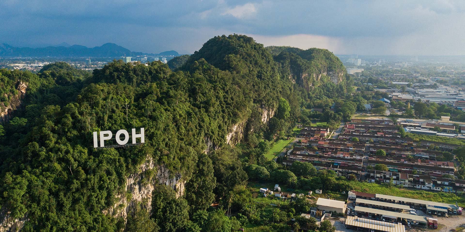
Stage 5: Coimbatore-Kotagiri
191 km
Mountain
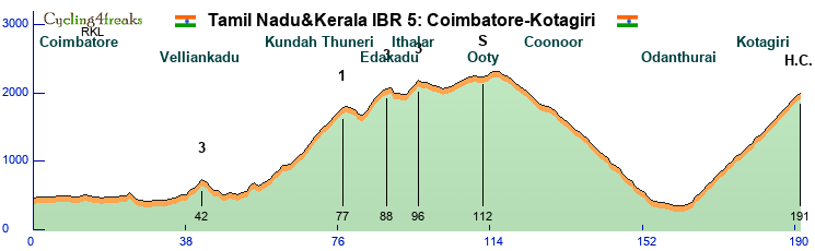
The second mountain stage of the Tour, and this one is much more difficult. From Coimbatore we head north towards the Nilgiri mountains. A first small hill at km 24 won't be hard enough to split the peloton, the next one, a 4km climb at km 42 can, but shouldn't play a role in the outcome of the stage. Serious stuff begins at km 54, where the irregular, 24km long 1200 altitude gain climb to Kundha Thuneri starts. Short downhill, followed by another 2 climbs, 6 and 3 km long, with a combined 8 km at over 6%. We have a 20 km flatter section, still hilly, but not selective going through Ooty, before we hit the long downhill, through Coonoor to Odanthurai. There we turn back north for the long final climb, 29 km from the moment it starts, 27 from the first km over 6%, 1650 meters up in total. Harder km mixed with easier ones, the last 10 km 7 6 6 6 7 6 7 6 7 4. Here a strong team will be important, not only for the earlier cat 1 (+ double 3) climb, but also for the long final climb, where an isolated leader will have difficulties reacting to all attacks himself. Or tire himself out if he tries on his own early. Still, normally easier to make differences here than on stage 3, so the GC should be clearer again. And the wearer of the leader's jersey can expect to keep it until stage 10.
We'll keep the tourist info short this time, Ooty, Coonoor, Kotagiri, all hill stations, cooler weather, popular with the English but also with Indians nowadays.

The Nilgiri mountain railway, going through Coonoor to Ooty.
Stage 6: Ooty-Kozhikode
172 km
flat
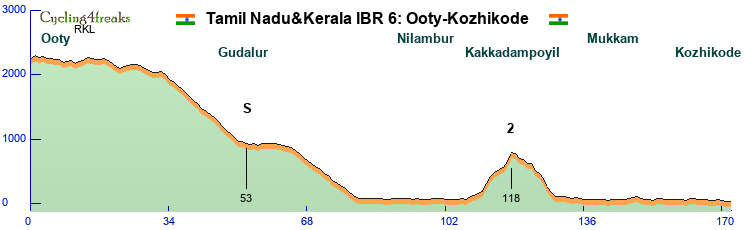
The third sprint stage, and this one looks good for hill sprinters. A slighly hilly start, but nothing over 5%, then a first downhill to Gudalur, where the IS of the day is located. Then the second part of the downhill, into Kerala. At around km 67 we'll cross into Kerala. The first difficulty in Kerala probably won't be popular with sprinters. A 7 km climb, 12 11 7 4 3 9 15, category 2 at km 118. From km 130 on then it's flat, but it's doubtful that these slighly over 40 km will be enough for flat sprinters to come back, they risk losing quite a bit on that hill. Lask km a 0, expectation is hill sprinters, but the flat ones are welcome to prove the organizing committee wrong. A very important stage for green.
Today we start in Ooty, as mentioned before, one of many hill stations, but this one is called the "Queen of the Western Ghats". So the most famous one of them all.?There's a railway going up to Ooty, as you saw in the picture of the previous day, but nowadays it's mostly a tourist attraction. Ooty is also often associated with tea, but actually most of it comes from Coonoor, Kotagiri or the surroundings of Ooty, Ooty itself is a bit too high up for tea plantations, they are at lower altitude. Ooty's official name is Udhagamandalam, but seldom used in daily conversation it seems.
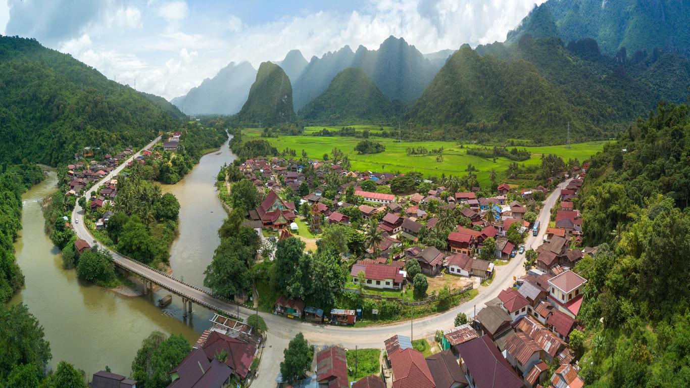
Kozhikode, our first stop in Kerala, was known as Calicut during colonial times. An important port, on the Arabian sea, which we reach today, Used to be the most important port on the Malabar Coast, the center of the spice trade, they even traded with Rome in antiquity. In the 16th century when the Portuguese showed up, Kozhikode's downfall began, it lost it's predominant status within a century, being overtaken by its historic rival further south, Kochi.

View from the road to Gudalur
Rest day:
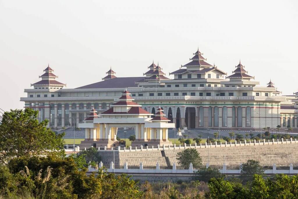
We will transfer from Kozhikode to Thiruvananthapuram. Thiruvananthapuram, the capital of Kerala. A mouthful, used to be known as Trivandrum, the colonial anglized name. c4f isn't made for Indian cities, too long for the title of the stage, so we had to cut the empty space between the : and the T. We proposed Trivandrum, but were shouted down. A hilly city, but not hilly enough to count as hilly in c4f.
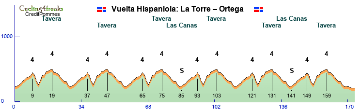
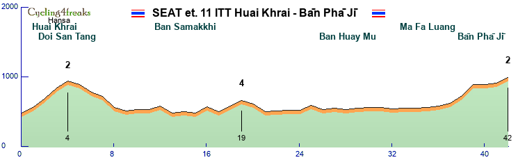
 Stage 7: Thiruvananthapuram-Erumely
197 km
Mintact at 152km
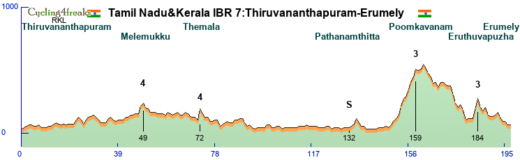
A hilly stage, an escape stage? With the long flat approach to the difficulties of the day it might be difficult to control a group. It's slightly hilly for much of the first part too, but only 2 short climbs that might put some riders into difficulty, the 2 cat 4, 6% for one, 9% for the other.
The final starts at km 153 with a 7 km climb to the beginning of the Poomkavanam forest, if that's what it's called. 7 6 1 6 6 4 6, a borderline cat 3 climb, almost cat 2. After 14 flatish/downhill km, in which we lose 100 meters the real downhill starts, just to be followed by the final difficulty of the day 9 7. 13 km to the end, down to Erumely, where the last km will be on a flat road.
Erumely should be pretty full at this time of the year. It's on the pilgrim way to Sabarimal temple, and the pilgrimage season is in December and January. The whole project might fail because of this, lack of accommodation. Otherwise a small town, 40'000 people. (that includes the surroundings, the center for sure is much smaller)

The forest road near Erumely, well, somewhere in the region although we don't use this exact road, should look similar.
Stage 8: Erumely-Kochi
131 km
flat
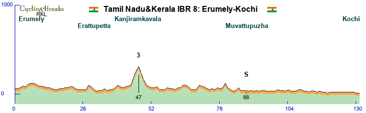
The fourth sprint stage, a short one, only 131 km. There is one difficulty on the day, a climb shortly before Muttam, tops out at 300m at Kanjiramkavala. 8 7 6, 3 km long, After that there's 2 more km at 5%, at km 70 and 80. So normally here the sprinters should have enough firepower to get the hill sprinters back, but depending on the composition of the field, it might be worth a try. A win for hill sprinters here would definitely eliminate flat sprinters from the fight for the points jersey. With stage 6 in the bag normally, they still have chance to win it even if this ends in a bunch sprint.
Kochi, known as Cochin before, now is the biggest city in Kerala, as well as the financial, commercial and industrial center. It long played second fiddle to Kozhikode, got protection from the Chinese (during the short time as a maritime power, before they decided to stop that completely, but that's another story) in the early 15th century protection from attacks by Kozhikode, then when the Portuguese arrived in the late 15th early 16th century Kochi sided with them. After that came the Dutch, then the English and now Kochi is the most important port and city on the Malabar Coast.

Nightview of Marine Drive in Kochi, where the finish of the stage will be, so the evening people don't need to worry, there's light!
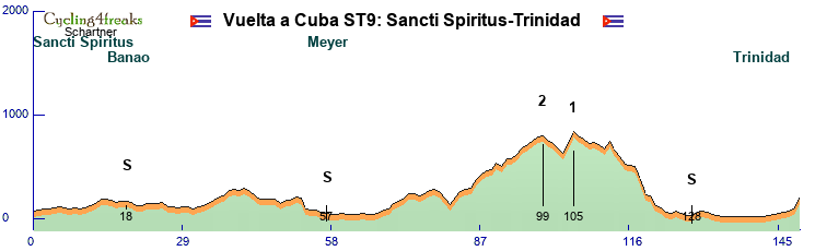
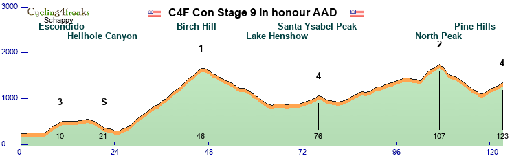
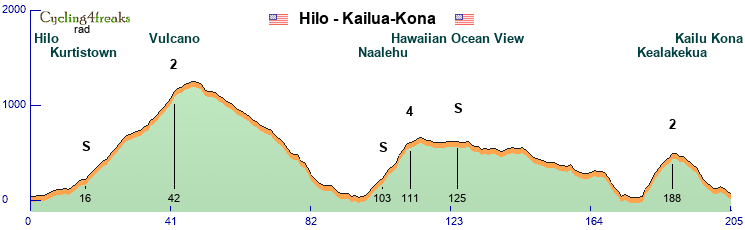
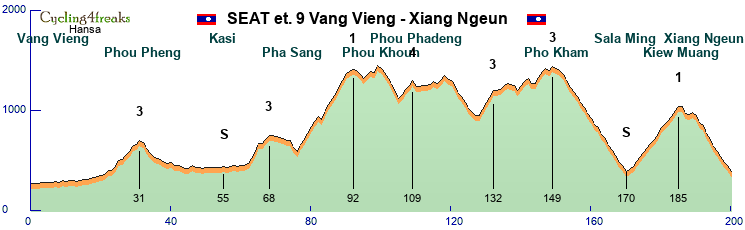
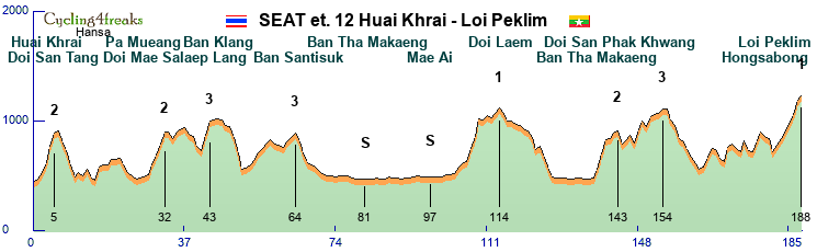
Stage 9: Kochi-Kattappana
204km
Hilly
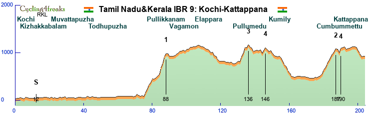
With the 3rd and last middle mountain stage the GC fight resumes. The first of 4 GC stages, being a middle mountain stage it won't necessarily result in GC action, but it could. GC team better be alert anyway. It starts easily, after 12km already there's the IS of the day, tempting the teams that want points for the points jersey. After that it stays flat until 76, where the first and hardest climb of the day starts. Back to the Western Ghats. The climb is in 2 steps, the first one gaining 360 meters in 5 km, one km down, 3 km at 3 3 5, the 13 11 13 7 to reach 960 meters. The teams will then have time to reorganize a bit, no difficulty until a 5 km climb topping out at km 136, there's a flat km in the climb, 9 9 11 0 7. 10 km later a 6 5 climb to some shops on top of the hill, called Odamedu probably. Down to Kumily, where we cross the border in Tamil Nadu again. Downhill followed by the climb to Cumbummettu, where at km 187 we cross back into Kerala. The climb is 8 km long 520 meters up. After a short flat-downhill, the last climb of the day, one short steep km up to Kuzhitolu temple. A very narrow but paved road. From there it's flat, with 4 downhill km at 5% or more until the finish in Kattappana. With a HC stage coming, and the long approach, not an easy stage to control, not for GC teams nor for team that only target the stage.
All is already said about Kochi, so Kattappana: Located in the Cardamon Hills, surrounded by hills, Cardamon and black pepper plantation, it has lately developed into a regional center.

The bus station in Kattappana, for those riders that had enough and want to leave by bus.
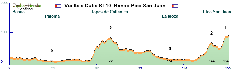
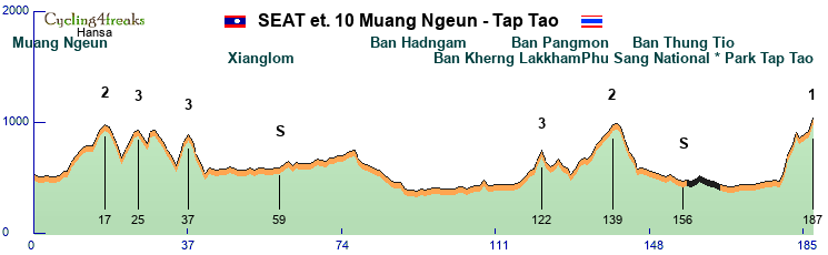
Stage 10: Kattappana-Munnar
136 km
HC
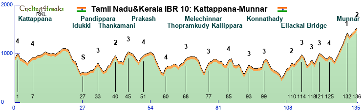
The queen stage. Stage 5 has more climbing, but is significantly longer, here it's packed into 136 km. Lots of small steep climbs, dangerous downhills. We start with a 8% climb to set the tone for the stage. Another 7 5% combination soon after, then the easy part of the stage starts. The IS this time is there for hill sprinters to take, if they want to control until km 27. After that the serious things start. The middle part of the stage, basically from km 32 to 106 is filled with small 1-2 km climbs, many of them with at least 1 km over 10%. Only longer climb is at km 40, 4 km, 3 of which over 6%. At km 106 we reach the lowest point of todays stage, 470 meters. From there the final starts 7 more GPMs, 17 of the last 30 km are at 6% or more, 6 downhill 6% or more. Flattest km are 3 km at -3%. The last climb is in 2 steps, the first one the hardest climb of the day, 9 11 13 12 14. After 1 km downhill at -8%, the last 3 km are 7 5 6. The steep 5 km climb of course risks castrating the race a bit, having such a wall at the end will encourage climbers to wait for that, but earlier attacks are possible too, always depending on the composition of the group of course.
Munnar, tea country. Like a bit everywhere in the hills of course. It's near the highest mountain in South India, Anamudi, at 2695 meters actually the highest mountain in India that is not in the Himalaya.

Tea....
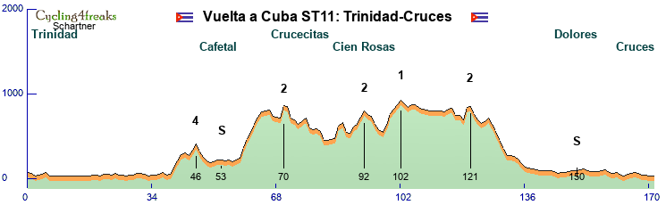
Stage 11: Munnar-Top station
34 km
TT
Mintact from km 1
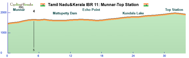
After the short, intense, hard HC stage the preceding day, today regeneration and TT skill will be necessary. We start in Munnar at 1460 altitude, finish in Top Station at 1900, climbing up to 1960 2 km before the finish. But we think (hope?) the TT should still be won by a TT rider, and not a GC rider. There's a km at 6% and one at 5% in the early climb, after that it's never more than 4%. Lots of +2 and +3. And then the last 2 km slight downhill, -4 -2. Might be too hard for pure TT specialists, but TT guys with some mountain capabilities, 60 should manage to stay ahead of the GC guys.
As for the GC, today probably the decisive day. 34 km is plenty to make big differences. Here the climbers with strong TTs will probably finally take command of the race, until now the climbers without TT should normally have been ahead in GC, the question is if they managed to build a big enough advantage.
Top Station is called Top Station because it used to be the top station of a ropeway. There used to be a railway from Munnar to Top Station, then from there a ropeway brought the tea down to the Valley. It's the lowest point in the crest there, so that's why it was used. Top Station is also in Tamil Nadu, just. We cross leave Kerala just 2 km before the finish. Since travelers from Tamil Nadu have to take a big detour through Kerala to reach this tourist destination with amazing views, in 2017 there were plans to build a road up where the ropeway used to be, thus cutting the journey by hours. Another possibility to reach Top Station would be from Kodaikanal, where we finish our stage tomorrow. But there's a national park in between, protected species, only dirt roads in part, so we didn't get permission from the authorities to go through there.

A cycling fan enjoying the view to the Valley from Top Station, while patiently waiting for c4f to visit.
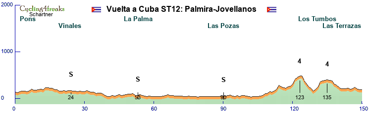
Stage 12: Dindigul-Kodaikanal
155 km
HC stage
mintact from km 108
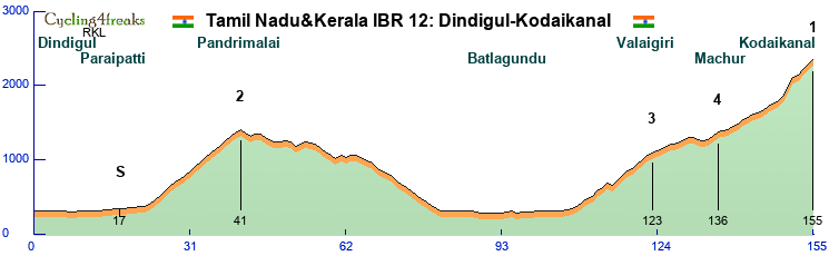
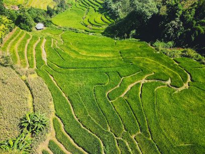
We thought the GC was decided yesterday? Most likely it was, but one last chance to change the GC. The 4th and final GC stage. We start in Dindigul, in the east of the Palani Hills, and start climbing after 24 flat km. At km 17 the intermediate, once again placed early, once again teams still in the fight for the points jersey might consider giving it a go. The first climb tops out at km 41 lots of 5 6 7, not very steep. A hilly downhill until 65, there the downhill back to the plain starts. Km 82-107 then are in the plain, the final climb starts at 108, with a 4. . A first step 7 km long, 3 km at 6% or more, a flat/downhill section near a viewpoint for some waterfalls, followed by a 8km steeper section again. Then it's nothing above 6%, with the exception of a km at 136. The climb continues being shallow, max 5 until km 149. A 6%. Km 150 we decide to leave the main road and instead go up through Kodaikanal with the direttissima, 14-11%, a 4% to reach the lake at Kodaikanal, then we climb above the center towards the Kodaikanal solar Observatory, 7 7 6.
Not a stage that looks easy to make up a lot of time, it's the last 7 km that most likely will decide the stage, and the GC too, if that one is still in play at this point.
Kodaikanal is... surprisingly another hill station. The princess of hill stations, seems all of them have rather annoying nicknames. Munnar is the Kashmir of South India At 2200 meters pretty high up, 36'000 inhabitants, tourism the main industry. Surpringly crowded in pictures, lots of cool steep roads in the northern part across a river, unfortunately that would have given us 1 or 2 flat km, so we stick to the finish near the Observatory. Somehow of all the hill stations the one the RKL would like to visit first.

The entrance to Kodaikanal, you see the main road where we take the direttissima.
Stage 13: Kodaikanal-Madurai
121 km
flat
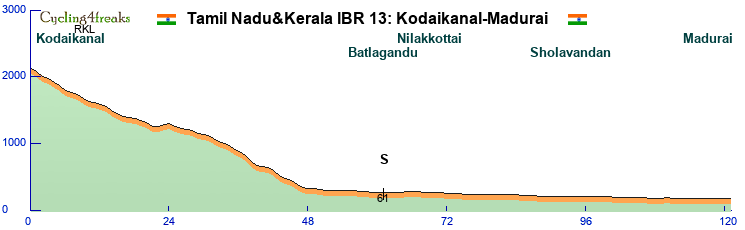
We finish like we started, with a stage for sprinters. Down from Kodaikanal and flat into Madurai. The downhill to Batlagandu is the same as the climb yesterday, except the first km where we took the shortcut yesterday. The percentages look differently, that's because the point of calculation was different. And because we didn't bother to retry and replot the downhill x times like we did for the climb. The downhill ends at km 47, after that it's lots of 0, never more than -1 down. A short probably intense sprinter stage, which favors sprinters with flat obviously. If the points jersey isnt' decided yet, it will be decided here. If the GC isn't decided yet, it won't be decided here either, that would mean that the Tamil Nadu&Kerala International Bicycle Race hasn't been ridden.
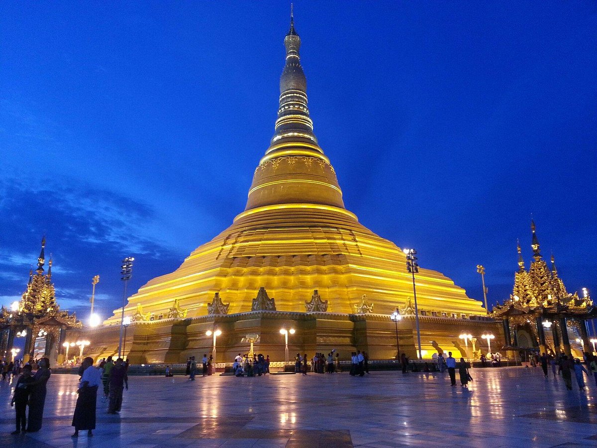
Now we had such a nice finish to the presentation, and we only remember now that we still have to present Madurai. Have to because Madurai is the cultural center of Tamil Nadu, a city with a long history, first mentioned 300 BC. And as cultural center it clearly deserves to welcome the final stage of this Tour.

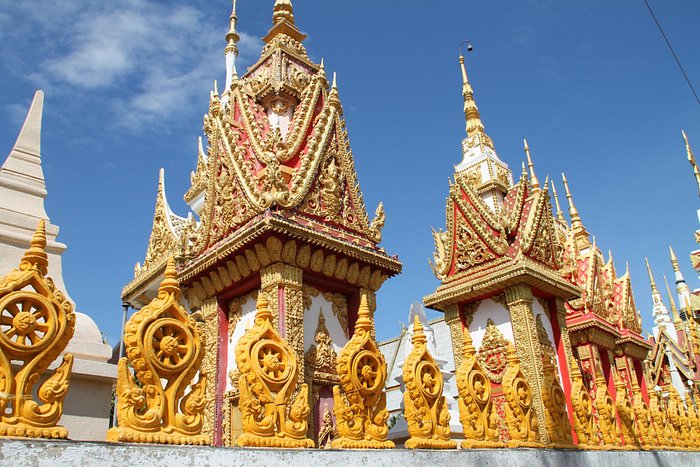
Menaakshi Temple, The city is actually built around this and Koodal Azhagar temple.