Welcome to the December Tour 2023 presentation thread. Here you can post your proposal for this year's competition.
ONLY presentations!
1 post per designer/tour.
No discussions or comments in this thread here.
That can (and should) be done in the rules and discussion thread: viewtopic.php?f=14&t=9628
Make sure to post your tour until the 31.10.2023. All posted tours are checked regarding rules and will be considered for the voting.
Links to the proposed Tours:
Vuelta Ciclística a Cuba viewtopic.php?f=14&t=9648&p=118474#p118474
Vuelta Hispaniola viewtopic.php?f=14&t=9648&p=118510#p118510
Kashmir Peace Tour viewtopic.php?f=14&t=9648#p118512
Tamil Nadu&Kerala International Bicycle Race viewtopic.php?f=14&t=9648&p=118694#p118694
Arakan Tour viewtopic.php?f=14&t=9648&p=118706#p118706
C4F Convention 2023 viewtopic.php?f=14&t=9648&p=118723#p118723
Hawaii Winter Race viewtopic.php?f=14&t=9648&p=118761#p118761
South East Asian Tour viewtopic.php?f=14&t=9648&p=118771#p118768
Kabylie Tour viewtopic.php?f=14&t=9648&p=118771#p118771
December Tour 2023 - Presentation
Moderators: systemmods, Calendarmods
-
flockmastoR

- Posts: 3134
- Joined: Thu Feb 18, 2010 11:42 pm
- Contact:
December Tour 2023 - Presentation
Boaz Trakhtenbrot:
Schrödinger's Dogs: Alive & Dead
- Winner Giro 2022
- 10 GC wins
- 16.609 Eternal Points
Schrödinger's Dogs: Alive & Dead
-
Schartner Bombe
- Posts: 221
- Joined: Sun Mar 18, 2018 5:48 pm
- Contact:
Re: December Tour 2023 - Presentation
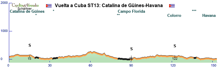
Vuelta Ciclística a Cuba
1964-2010
I have interpreted the tour in 13 stages without restday.
Stage 1: 197km
mixture flat/hilly with 6% at km 170
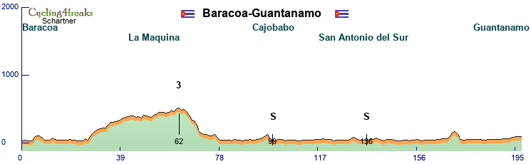
Stage 2: 185km
km 165-167 ... ** 1 2 1 6%
km 172-173 ... 8 6%
Stage 3: 179km
km 168-179 ... 4 3 12 7 6 9 12 11 11 5 13 8 6 2 -1%
Stage 4:158km
dirty road in the middle with 15% and * or **
km 111-117 ... 16 12 10 11 2 7 5%
Stage 5: 175km
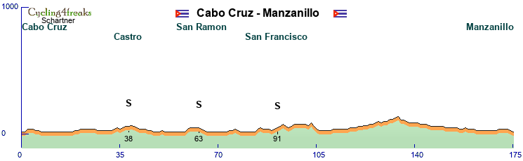
Stage 6: 179km
Stage 7: ITT 40km
Stage 8: 152km
Stage 9: 149km
km 104-105 ... 9 12%
last 5 km ... 1 1 1 3 9%
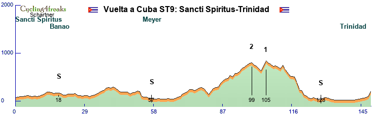
Stage 10: 156km
km 132-144 ... 2 1 4 2 6 2 2 5 4 10 15 3 4%
km 150-156 ... 3 4 15 14 9 -3 4%
Stage 11: 171km
till 15%
Stage 12: 150km
Stage 13: 153km

1964-2010
I have interpreted the tour in 13 stages without restday.
Stage 1: 197km
mixture flat/hilly with 6% at km 170
Stage 2: 185km
km 165-167 ... ** 1 2 1 6%
km 172-173 ... 8 6%
Stage 3: 179km
km 168-179 ... 4 3 12 7 6 9 12 11 11 5 13 8 6 2 -1%
Stage 4:158km
dirty road in the middle with 15% and * or **
km 111-117 ... 16 12 10 11 2 7 5%
Stage 5: 175km
Stage 6: 179km
Stage 7: ITT 40km
Stage 8: 152km
Stage 9: 149km
km 104-105 ... 9 12%
last 5 km ... 1 1 1 3 9%
Stage 10: 156km
km 132-144 ... 2 1 4 2 6 2 2 5 4 10 15 3 4%
km 150-156 ... 3 4 15 14 9 -3 4%
Stage 11: 171km
till 15%
Stage 12: 150km
Stage 13: 153km
- Attachments
-
- Cuba Tab.png (110.5 KiB) Viewed 1505 times
Re: December Tour 2023 - Presentation
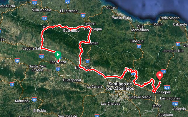
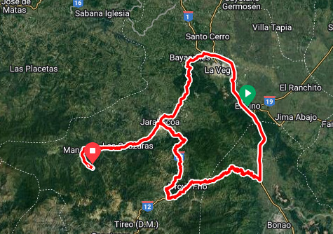
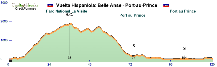
Vuelta Hispaniola
13 Stages 1 Restday
4Flat, 4Hilly, 4Mountain, 1ITT

Stage 1: 194 KM, +9 at KM154, 1150 HM
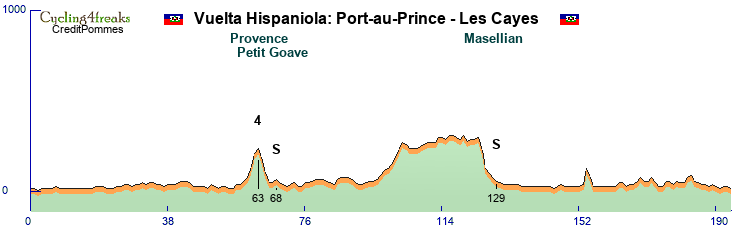
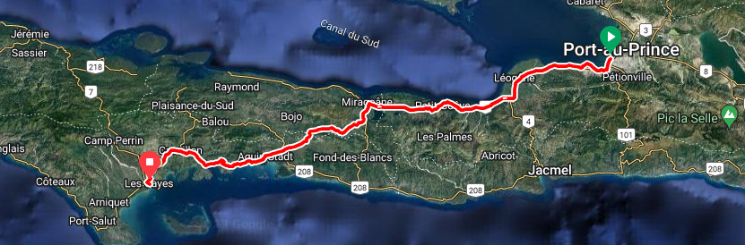
Stage 2: 176 KM Queen Stage, 4930 HM
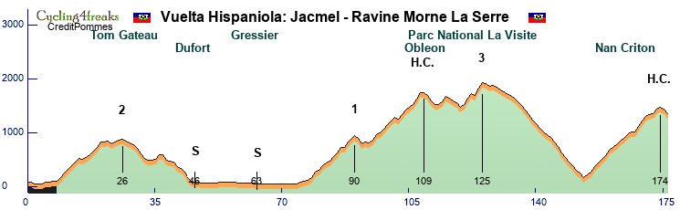
Stage 3: 180 KM +12,+12,-4,+4,+11,+12 KM 145-150, 1640 HM
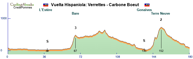
Stage 4: 161 KM Pure Flat, 650 HM

Stage 5: 165 KM Many Short 3-5 KM Climbs +8,+9,+11 Last three KM, 3280 HM
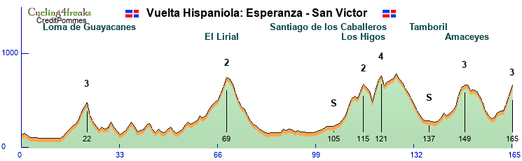
Stage 6: 179 KM, KM 128 +17 after that no km with more than +5, 2360 HM
Stage 7: 169 KM no Sieb after KM 52, 1080 HM
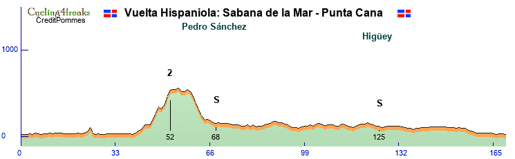

Restday

Stage 8: 40 KM ITT, 190 HM
Stage 9: 146 KM first 100 basically flat, 3060 HM

Stage 10: 210 KM longest Stage +7+7 last two KM, 4140 HM
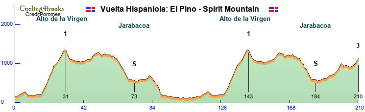
Stage 11: 173 KM Many Short Climbs but only 2 +7 km per Round, 2770 HM
Stage 12: 197 KM last sieb at KM 102, 1250 HM
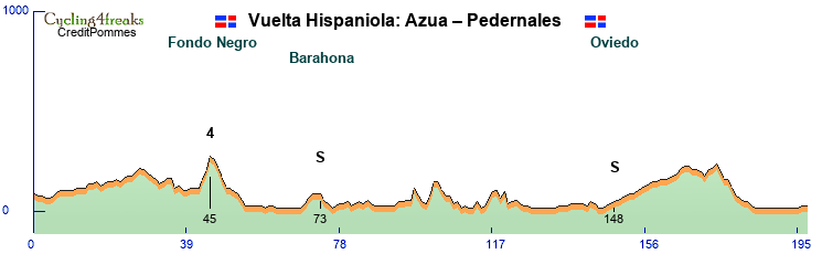

Stage 13: 121 KM 116-117 +5, 2780 HM

13 Stages 1 Restday
4Flat, 4Hilly, 4Mountain, 1ITT
Stage 1: 194 KM, +9 at KM154, 1150 HM
Stage 2: 176 KM Queen Stage, 4930 HM
Stage 3: 180 KM +12,+12,-4,+4,+11,+12 KM 145-150, 1640 HM
Stage 4: 161 KM Pure Flat, 650 HM
Stage 5: 165 KM Many Short 3-5 KM Climbs +8,+9,+11 Last three KM, 3280 HM
Stage 6: 179 KM, KM 128 +17 after that no km with more than +5, 2360 HM
Stage 7: 169 KM no Sieb after KM 52, 1080 HM
Restday
Stage 8: 40 KM ITT, 190 HM
Stage 9: 146 KM first 100 basically flat, 3060 HM
Stage 10: 210 KM longest Stage +7+7 last two KM, 4140 HM
Stage 11: 173 KM Many Short Climbs but only 2 +7 km per Round, 2770 HM
Stage 12: 197 KM last sieb at KM 102, 1250 HM
Stage 13: 121 KM 116-117 +5, 2780 HM
Last edited by C.Pommes on Sun Oct 08, 2023 3:30 pm, edited 2 times in total.
Re: December Tour 2023 - Presentation
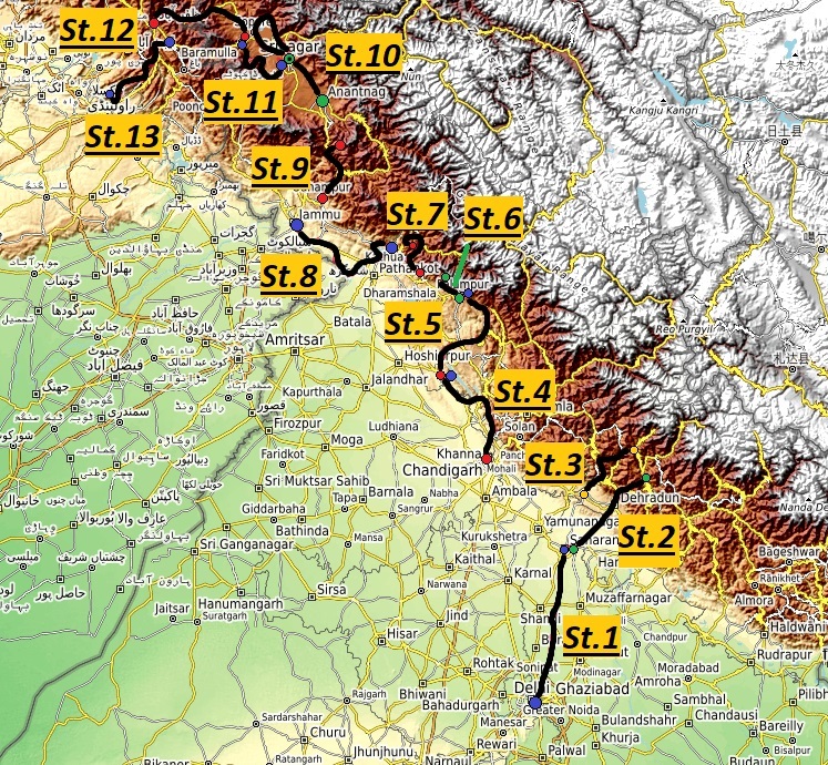
Kashmir Peace Tour 2023
Introduction
Many of you will know that there is a swelling conflict between India, Pakistan and China called the „Kashmir conflict“.
When India was partitionated in 1947 both India and Pakistan claimed to be the righteous owner of the former princely state „Jammu and Cashmir“.
Moreover china stated that the „Aksai Chin“ should be an integral part of china and therefor it did not accept the boundaries of Jammu and Kashmir while generally standing more or less on the pakistani side.
This conflict escalated into 3 wars between those countries and even more other armed skirmishes.
After pakistani surrender in 1971 the Simla Agreement between Zulfikar Bhutto and Indira Gandhi stated that the conflict should be resolved and that the status quo should be held until a durable peace is established.
Unfortunately also the following 50 years brought no peace but an everlasting conflict resulting in senseless skirmishes, the strenghtening of islamism and violations of human rights.
To stop this horrible spiral of fighting the diplomatic department of Team Trojer Vellau, generally known as the most peaceful cycling team in the world (at least in its own view) invited the heads of all 3 states as well as the kashmir regional government to the teams headquarter in southern tyrol to suggest them an idea that could show that all are interested in peace and friendship.
All 4 parties were immediately enthusiastic of the idea of a road race in the conflict region bringing not only joy to the people but also to be seen as background for further negotations about the future.
While the chinese government said the race couldnt be held in Aksai Chin cause there are no more valuable streets between Kashmir and Aksai Chin they promised to send a delegation to the race which therefor will be held between Indian Capital New Delhi and Pakistans capital Islamabad passing different municipalities including some decisive stages in Kashmir and Jammu.
And so the „KASHMIR PEACE TOUR 2023“ was born.
Teams from all over the C4F world will be invited to contend!
General Information
9 riders per team
13 Stages + 1 Rest Day in total split into:
5 Flat Stages
4 Middle Mountain Stages
3 H.C. Mountain Stages
1 Individual Time Trial
2.060 km in total
158 km per stage (169 km excluding ITT)
29510 hm in total
2270 hm per stage (2369 hm excluding ITT)
101 min average riding time (107 min excluding ITT)
Stage presentation will be the following:
Stage Number – Stage start to stage finish – Stage Type – Stage length – Stage ascent – Mintact at km: xxx – Stage duration: xxx min
Rules for IS and GPM
2 intermediate sprints per stage valued with 6-4-2 points for the first 3 riders and 3,2,1 seconds
The GPM will be categorized and presented as follows:
The start of a climb will normally the first 4+ km, but there may be exceptions like a climb starting with lower percentages directly after a downhill with no flat part in it.
Cat. 4 - >200hm or presenters choice - Name - KM - Length - HM - average steepness
Cat. 3 - >400hm and 5% or over 200hm and 6% - Name - KM - Length - HM - average steepness
Cat. 2 - >600hm and 5% or over 400hm and 6,5% - Name - KM - Length - HM - average steepness - Steepest KM
Cat. 1 - >800hm and 5% or over 600hm and 6,5% - Name - KM - Length - HM - average steepness - Last 10km and Steepest km
HC - >1500 hm and 5% or over 1000hm and 6,5% or Most HM - Name - KM - Length - HM - average steepness - All km starting from the first 4+ and Steepest km
If a climb doesnt fit the xxx hm and 5% criteria it will be classified 1 category lower.
E.g. 1050 hm and 4,5% would be a category 2 climb.
If a climb has special characteristics but does not fit certain criteria its up to the designer to choose another category.
It will be then explained in the stages description.
10,6,4 second on all stages except ITT in the finish!
Stage 1 – New Delhi to Saharanpur – Flat Stage - 173 km – 90 hm – Mintact at KM: 143 – Stage duration: 102 min
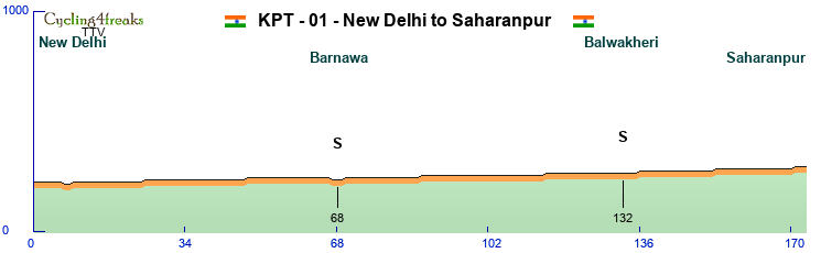
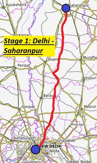
The tour starts directly in the heart of New Delhi not only indias capital but a pulsating city with only 250k inhabitants but part of the mega-city of delhi worlds 3rd biggest metropolitan region with over 32 million inhabitants. It was founded in 1911 to follow Kalkutta as capital of british india. On the long way out of New Delhi riders will straight head to the north on flat roads and after leaving New Delhi through mostly uninhabitated places through the little villages of Barnawa and Balwakheri where the 2 intermediate sprints of the day will be the only places where riders heart rate might go up before reaching Saharanpur.
Shaharanpur named after the islamic holy Shah Haran Chishti is an 700000 inhabitants city in the district of Uttar Pradesh and will most likely be a very big invitation for the sprinters.
Intermediate Sprints:
KM 68 – Barnawa
KM 132 – Balwakheri
GPM:
-
Stage 2 – Saharanpur to Maa Ganga Airport – Middle Mountain Stage - 177 km – 2950 hm – Mintact at KM: 132 – Stage duration: 111 min
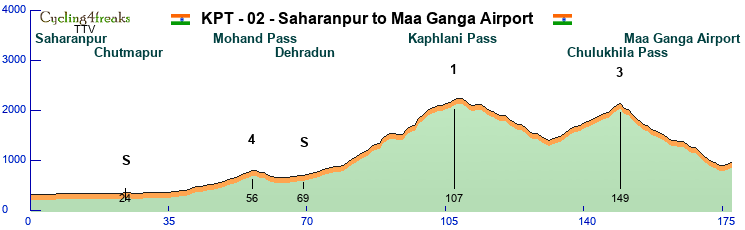

The second stage starts again in Saharanpur and heads north again. After passing Chutmapur and the pretty small Mohand pass the capitol of the district of Uttarakhand Dehradun a 650000 inhabitants city will be passed where also the second of the intermediate sprints takes part which could also be reachable for sprinters. Afterwards the mountains of this district will be reached with first the big climb up to the Kaphlani pass which is nearly 2200 meters high and has some steep km but is all in all more a flat one. After a downhill back to 1400hm where the riders can get back some power the second pass „Chuliklila“ waits for the riders where the fight for the win will be decided most likely. Or will it be the second long downhill leading our riders to the Tehri River with even a short flat part in the end?
The finish will me then at the field of Maa ganga airport which was built for pilgrims. So maybe some holy help for the riders?
Intermediate Sprints:
KM 24 – Chutmapur
KM 69 – Dehradun
GPM:
Cat. 4 - Mohand Pass - KM 56 - 7 KM - 230 hm - 3,3%
Cat. 1 - Kaphlani Pass - KM 107 - 28 KM - 1420 HM – 5,1% – 14,5,8,7,2,4,-1,5,1,7 - Max. 14% (98)
Cat. 3 - Chulukhila Pass - KM 149 - 18 KM - 740 HM – 4,1%
Stage 3 – Barkot to Herbertpur – Middle Mountain Stage - 157 km – 2420 hm – Mintact at KM: 100 – Stage duration: 107 min
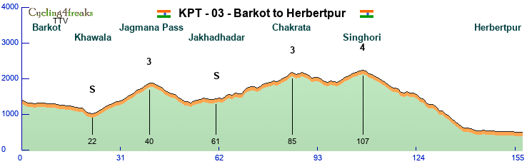
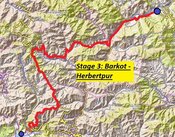
From Maa Ganga its just a short transfer to Barkot also in the Uttar Pradesh District. The 17000 inhabitants city is located on the banks of the Yamuna river. From there the riders will first go to the west in a small downhill part until the first sprint which is located in Khawala. Some km after the Jagmana Pass is awaiting with some steep km but all in all not with big problems for the most riders most likely. What still has to be mentioned that the pass starts very flat and gets steeper in the end so maybe someone still wants to try here to get rid of weaker riders. The next 30km are then down with some uphill splitted by the second IS at Jakhahaddar before the second climb of the day starts. Its again around 600hm but only 3,7% in average thanks to some little downhills and flat parts but still there are enough steeper km where siebs can happen. But the real decision about the stagewin will maybe happen 20km later on the last little climb to the village of Singhori just 50km from the finish. This one has only 2 siebkm but maybe someone tries it or will even hillsprinters or sprinters go the hard and long way and use the following 35km of downhill and 15km of flat to catch up with guys with more mountain? Anyway the end of the stage will be in Herbertpur (yes its called after a Sir Herbert so a remainder of british colionalism but still a very nice place in between flatlands and mountains!)
Intermediate Sprints:
KM 22 – Khawala
KM 61 – Jakhahadar
GPM:
Cat. 3 - Jagmana Pass - KM 40 - 18 KM - 840 hm – 4,7%
Cat. 3 - Kaphlani Pass - KM 85 - 16 KM - 590 HM – 3,7%
Cat. 4 - Singhori - KM 197 - 8 KM - 340 HM – 4,3%
Stage 4 – Chandigarh to Nangal – Flat Stage - 155 km – 1650 hm – Mintact at KM: 125 – Stage duration: 103 min
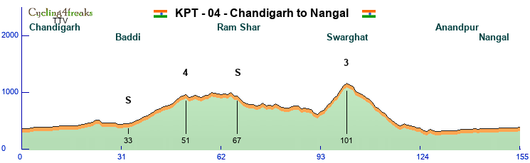
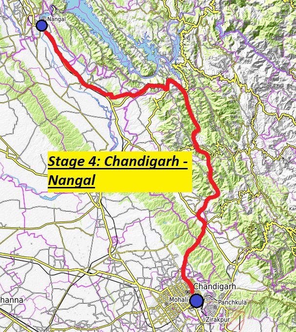
Chandigarh is an interesting city to start. The million city is not only the municipality of the territories Punjab and Haryana. The city has also been planned by the famous swiss architect Le Corbusier. But there is not so much time so stay there so the riders ride north crossing the boarder to „Himachal Pradesh“ where the first sprint is held in the little city of Baddi. Afterwards the ride continuos further north reaching the first unnamed pass of the day which is long but really not steep and shouldnt cause problems to any of the sprinters. The next 40km are more or less a downhill on narrow streets with some short climbs in it, but as any gradient over 5 is missing it shouldnt really be a problem for sprinters to keep on if they are kept fit – On the way they could also take the second sprint of the day but it will be more likely one for escapers. The real problem for them awaits then in the climb to Swarghat where some hillsprinters or even classic riders could try to split the field. Now there are 50km left for the groups to find together again. After a downhill over nearly 1000hm the mintact will start giving the riders more time to have at least a look at the city of Anandpur one of the most sacred places of Sikhism the 4th biggest world religion. After 30 flat km the riders finally reach Nangal where everything between strong classics with sprint and sprinters with strong flatteam can happen.
Intermediate Sprints:
KM 33 – Baddi
KM 67 – Ram Shar
GPM:
Cat. 4 – Unnamed Pass - KM 51 - 14 KM - 470 hm – 3,4%
Cat. 3 - Swarghat - KM 101 - 9 KM - 540 HM – 6,0%
Stage 5 – Nangal to Palampur – Middle Mountain - 198 km – 3400 hm – Mintact at KM: 156 – Stage duration: 118 min
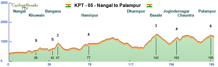

Nangal will also be the starting place for a hard triple of stages with this one most likely something more for a 85-65 or 75-80 then a 90-50 mountain rider. Before the next day also some brave earlier attacker could be the big winner and part of the peace process. But before we talk to much about our heroes let the cycle speak and present the route. The first 30km parallel to the Gobidi Sagar lake are more or less light hills with always up and down but the sprinters could be able to get points at the first sprint still. But already a little later they might be siebed at the first hill even if it is not categorized but contains a 7. Those that survive it have another chance for sprint points before the real action starts because even if the first pass is only 4km long it gives a good chance to reduce the field already for a strong team.
A last little downhill and flat part is awaiting before the riders reach Harmirpur and therefor also the so called „lower Himalaya“ … guess all riders know what that means. But wait – What most guys wont know is that between the lower and the real Himalaya the roads where built mostly over smaller passes and also in valleys so in fact there are more km to relax at least a little (or to keep the helper advantage with some strong flat and downhill riders) before 70km from the finish the 3 real mountains of the day await.
The first one of them up to Basahi will be clearly the hardest of them with even some 12% in it but as it is still 55km from the finish it is not so sure something big for gc could happen here but maybe a weaker mountain rider without gc chances wants to try his luck here? Only a short downhill is there to relax and then it goes to the city of Jogindernagar which is the terminus of the famous „Kangra Valley narrow gauge railway“. Afterwards the riders first down follow the main road but the small road to the Sukar Khad river which results in the last 2 „sieb km“ just about 30km from the finish before the riders pass Chauntra a Tibetan colony (which might be a hint for the next day). After another little flat and downhill part it goes up the final climb to Palampur which is mostly famous because Dr. Jameson intruced the tea bush there. Now the Kangra tea of Palampur is internationally renowned! Tea could be also something our riders might like after the quite long but not steep climb which favours definitely classics and 80-70s over real mountain riders. The finish is then also more in favour of those as its 3km with -2% gradient.
Intermediate Sprints:
KM 26 – Khuwain
KM 42 – Bangana
GPM:
Cat. 3 – Unnamed Pass - KM 47 - 4 KM - 300 hm – 7,5%
Cat. 4 - Hamirpur - KM 74 - 9 KM - 310 HM – 3,4%
Cat. 3 - Basahi - KM 142 - 12 KM - 680 HM – 5,7%
Cat. 4 - Jogindernagar - KM 162 - 6 KM - 300 HM – 5,0%
Cat. 4 - Palampur - KM 195 - 9 KM - 360 HM – 4,0%
Stage 6 – Palampur to Dharamshala – ITT - 38 km – 1080 hm – Mintact at KM: 1 – Stage duration: 38 min
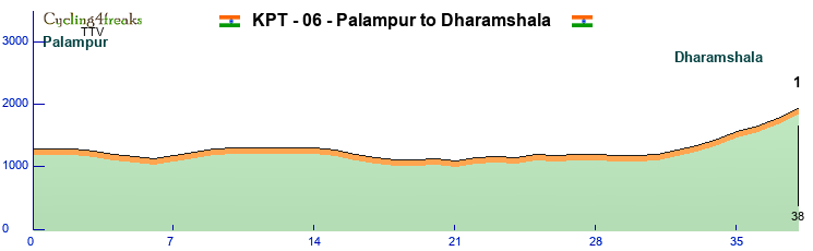

You heard something about Palampur before and the most of the road is flat so concentrate on the finish of this ITT which will be very decisive in the GC this time. Dharamshala means „house of the pilgrim“ and is one of the most famous cities in india. First the riders will pass „lower dharamshala“ also called Kotwali bazar which is somehow the business center there but also a very poor city. Until here the road is flat before the riders will take the 9km (7km of them steep) to upper Dharamshala which was originally founded as McLeod Ganj a summer residence for the brit emperors. Nowadays this place is much more known for something else. Its the exile of Tendzin Gyatsho the reigning Dalai Lama. Therefor every year thousands of pilgrims come to this sanctuary of Buddhism which is also called „Little Lhasa“. Hopefully riders can enjoy this spiritous ground after a long and steep climb.
Intermediate Sprints:
-
GPM:
Cat. 1 – Little Lhasa - KM 38 - 7 KM - 730 hm – 10,4% - 6,8,11,11,9,13,15 – Max. 15% (Km 38)
Stage 7 – Sihantu to Panchpulla – H.C. Mountain Stage - 141 km – 4440 hm – Mintact at KM: 85 – Stage duration: 103 min
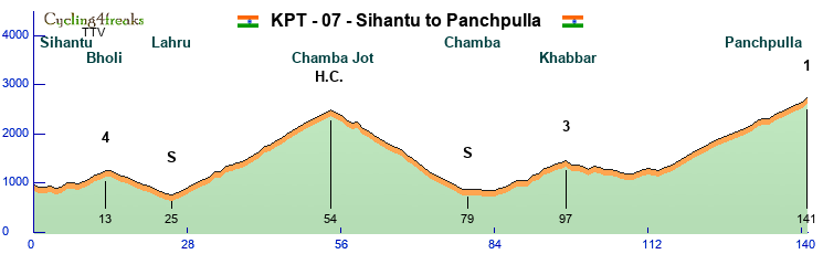

The last stage before reaching the Jammu and Kashmir district starts just 50km away from Dharamshala but the profile is totally different as we see the first of 2 real hard mountain stages of this tour. With the rest day awaiting it will be a question of power left from the hard ITT yesterday which rider will prevail! Starting nordwards from Sihantu a small city the Bholi pass which will not be a big obstacle for most guys is nearly directly awaiting. Afterwards the deepest point of the stage is reached before the first of 2 climbs starts which is harder but not as long as the second one. But before Lahru is very happy to host the first sprint of the day. The now following Chamba Jot pass has been subject to many descriptions as one of the most beautiful places all over the Himalaya … We will just cite here „The complete silence and the sunlight breaking through the clouds to light up the mountains will make you awe and ponder over the beauty of nature“. But the riders will more likely suffer and ache over the steepness of this climb. And dont wonder about „only 5,3%“ as its very unrhytmic to ride! The following 30km will give the riders time to regroup while the pass the second IS of the day in Chamba the small city on the foot of the mountain. Now the riders change direction to the west and follow the steep coast of the ravi river between India and Pakistan to Khabbar where only a smaller mountain is waiting for them but it is still not to underestimate. As this climb is also very unrhytmic (flat until 12%!) because its now only 20km left until the final climb starts! The Panchpulla waterfall that is to be reached lies in a height of nearly 2700 meters and is well known as a natural miracle. But to get there riders will have to climb up a very long climb but at least its by far not as unrhytmic as the Chamba climb but more or less always the same! Lets see if someone will lose much time after the ITT before, if someone even gave away the gc the day before for that stage and then we wish all a happy restday!
Intermediate Sprints:
KM 25 – Lahru
KM 79 – Chamba
GPM:
Cat. 4 – Bholi - KM 13 - 9 KM - 370 hm – 4,1%
Cat. H.C. – Chamba Jot - KM 54 - 31 KM - 1640 HM – 5,3% - 4,5,6,6,6,5,4,12,-1,11,2,5,3,7,5,8,11,4,9,8,7,6,7,5,6,4,6 – Max. 12% (Km 34)
Cat. 3 - Khabbar - KM 97 - 13 KM - 620 HM – 4,8%
Cat. 1 - Panchpulla - KM 141 - 33 KM - 1480 HM – 4,5% - 10,1,0,9,6,5,5,5,5,8 – Max. 10% (Km 132)
REST DAY – REST DAY – REST DAY
Stage 8 – Basohli to Jammu – Flat - 183 km – 830 hm – Mintact at KM: 153 – Stage duration: 96 min
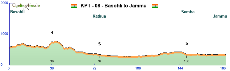
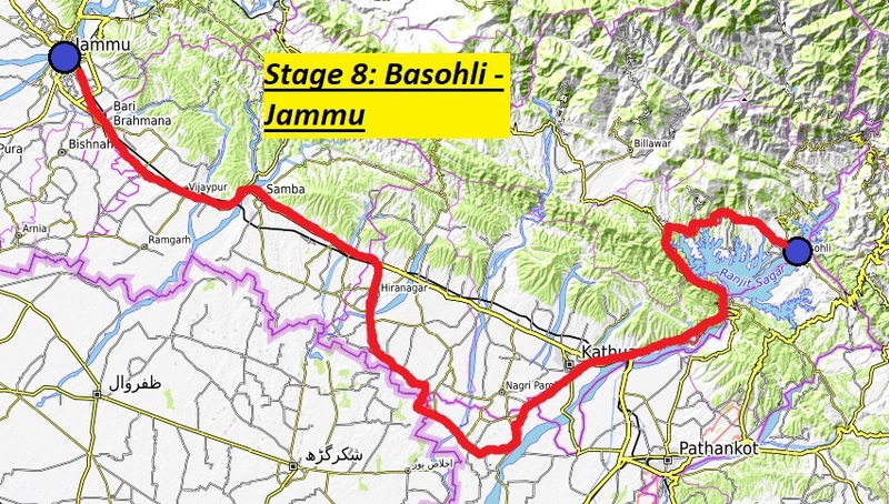
On the rest day the riders were transferred to Basohli a small city directly located on the River Ravi which is actually the boarder between the Union district of Jammu and Kashmir and the rest of India.
First the riders have to ride around the Ranjit Sagar which is a artificial lake for power production and one of the 10 biggest dams in India.
Here the road is also more or less a little up and down culminating in a small pass on the west side which might make some guys attack that want the polka dots but clearly should not be any problem for the sprint teams with nearly 150km more to come. The following downhill brings the riders back to the level of river ravi which will now be followed for around 45km with a IS in the city of Kathua (50000 inhabitants but not much more to know about it). The next 30km will be ridden west directly along the boarder to Pakistan before turning away from it again. The riders will then reach the National Highway A1 which they follow for the last 50km of this stage. First the last IS in Samba (which has nothing to do with famous Sambal Oelek!) is there to compete for. Afterwards the riders directly reach out to Jammu which is the second biggest (around 500000 inhabitants) city of Jammu and Kashmir and has always been since the times of the Maharadschas and still is the „winter residence“ of the Jammu and Kashmir government.
Intermediate Sprints:
KM 76 – Kathua
KM 150 – Samba
GPM:
Cat. 4 – Unnamed - KM 36 - 5 KM - 210 hm – 4,2%
Stage 9 – Udamphur to Panila – H.C. Mountain - 135 km – 3190 hm – Mintact at KM: 96 – Stage duration: 97 min
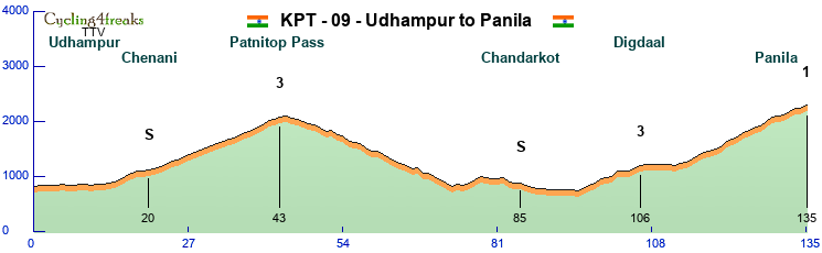
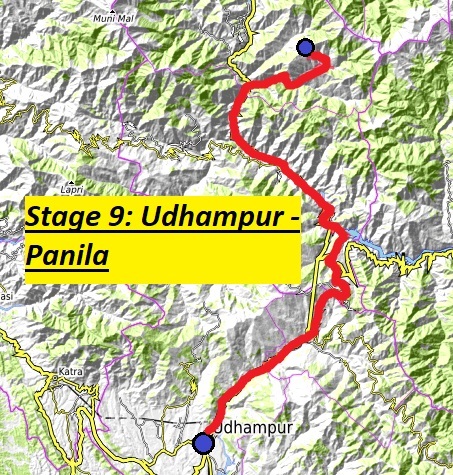
The sprinters had their fun so the mountaineers should have and its maybe the last chance for them to gain bigger time differences, while the following stages will all be hard but clearly nothing for someone who needs minutes. The city of Udhampur where the stage starts is mostly known as command of northern forces of Indias military, so nothing really lovely. Reason enough to directly leave the city to the north and have a first IS in Chenani. We will see if sprinters are still there as a little climb directly before the IS might have siebed them out already. Riders could now take the easy way through the „Dr. Syama Prasad Mookerjee Tunnel“ (with over 9km the longest road tunnel all over india!) but as it is a mountain stage no way so they will have to take the long and hard climb to the Patnitop pass on the former national highway. Its characteristic might be more for a strong team gaining an helper advantage then a big attack though as it is really long but not steep at all with max. a 7% in it. The following 50km will be a nearly perfect downhill to repower and regroup first steeper and then after a short counterslope more flattish alongside the Chenab river, also passing Chandarkot there were the last IS of the day will happen.
In Ramban the main road will be left and after only a few km alongside Chenab river the road turns sharply north and directly into the mountains for 40km of climbing action. Still those 40km are more or less divided into 2 parts. First there are 11 pretty unrhytmic km through a narrow valley to Digdaal. There the valley then widens up a little with some nearly flat km before the last 23km and over 1100hm await the riders. Here we might have a first „predecision“ of the tour winner but at least 2 more chances to switch the gc around wait still! Attention as it is in total still a 1600hm climb it will be categorized as 1 not as 2 so Polka dot riders can be happy!
Intermediate Sprints:
KM 21 – Chenani
KM 85 – Chandarkot
GPM:
Cat. 3 – Patnitop Pass - KM 43 - 23 KM - 870 hm – 3,8%
Cat. 3 – Digdaal – KM 106 – 11 KM – 470 hm – 4,3%
Cat. 1 – Panila – KM 135 – 23 KM – 1110 hm – 4,8% - 5,3,7,8,3,2,6,6,-1,7 – Max. 10% (KM 121)
Stage 10 – Anantnag to Srinagar – Flat - 188 km – 510 hm – Mintact at KM: 158 – Stage duration: 109 min
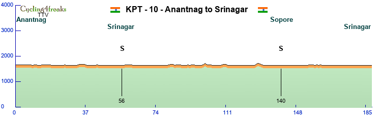
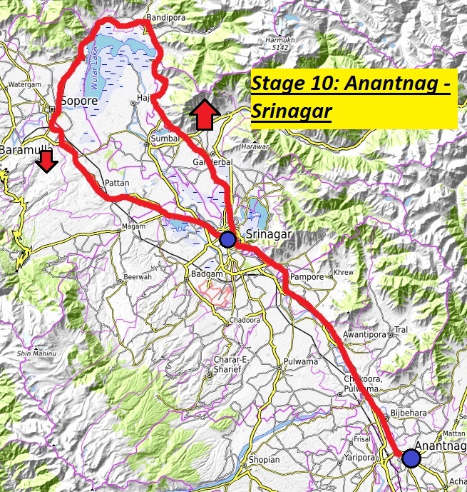
The last of 3 clear sprinter stages is waiting. After the only longer transfer of this tour (around 3.5 hours) to Anantnag not only 3rd biggest city of Jammu and Kashmir, economic centre of the Kashmir valley but also the seat of the university of Kashmir the ride starts always along the Highway to Srinagar which is clearly the most important city all over Jammu and Kashmir beeing its capitol and summer residence of the government, but also more as double as big as Jammu and the oldest known city in the hole district founded in the 3rd century B.C. by King Ashoka . Therefore it deserves to have an IS before the road continues north by northwest and going around the Wular / Wolar lake which is one of the biggest fresh water lakes all over south asia with 189km² of square. Here around the lake also the only 2 very small possibilites to get rid of sprinters wait at km 100 and km 128 with single 5s. After 12 more kms Sopore is reached where the Jhelam river leaves the lake with an IS and then the road heads back directly to Srinagar which is the only city beeing – due to its importance for Jammu and Kashmir – 3 times visited at this tour hosting IS, stage finish and stage start the next day.
Intermediate Sprints:
KM 56 – Srinagar
KM 140 – Sopore
GPM:
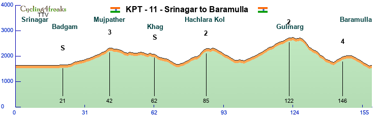
Stage 11 – Srinagar to Baramulla – Middle Mountain – 159 km – 2690 hm – Mintact at KM: 103 – Stage duration: 109 min
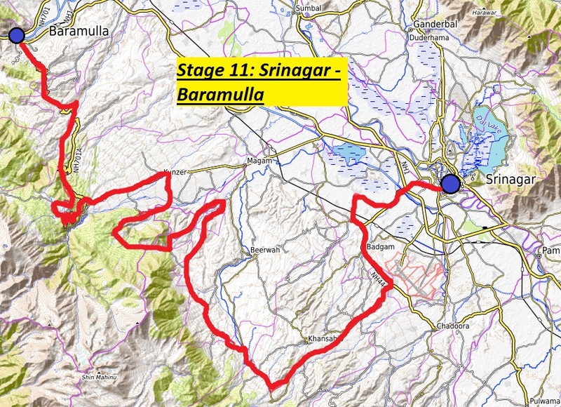
After sprinters had their fun yesterday today it could be the big chance for riders that havent fulfilled their goals yet e.g. some brave hillstrong escapers! Or will a strong classics team give full throttle today risking to be to weakened to keep the sprinters away a last time tomorrow?
Starting in Srinagar as we announced the route first goes flat through the suburbs into Badgam which is also a part of Srinagar still with IS nr. 1 of the day. Afterwards the road starts rising slowly for the first time to Mujpather where we will the first fight for the dots. This climb is also as we know it from stages before pretty long but not so steep that the field will totally explode which will be even more favourable as the only siebkms are directly at the start and then 2km from the top. Next there will not be a real downhill but just some km and a longer flat part before the real downhill starts directly after the IS at Khag. Riders could now take the direct way to the Gulmarg road but unfortunately that would lead to an disqualification because the stage really would have been much to short and easy then. So they will after reaching the valley again take a sharp turn to the west and head up to Hachlara Kol named after a rivers source there. This climb is stronger especially in the second part and might force some teams into higher tempo or a early attack.
Riders will have again some km to regroup before the biggest climb of the day awaits – reaching the Gulmarg skiing station (valley station) which is one of the most famous resorts all over asia with great freeriding possibilities up to nearly 4000meters above sea level at its top station and no groomed slopes at the main gondola. But thats not what riders are here for … the will have much less to do on the long climb that is pretty steady around 4-5% interrupted by two steeper parts (max. 7%). After riding round the Gulmarg golf course the route heads steady downhill to Baramulla but in between there is another little hill awaiting that will bring the final decision. But as it is followed by some more or less flat km and the downhill it wont be enough for mountain guys normally … So in Baramulla the district municipality located at the Jhelam river it will be escapers or classics to be happy we assume!
Intermediate Sprints:
KM 42 – Badgam
KM 62 – Khag
GPM:
Cat. 3 – Mujpather - KM 42 - 17 KM - 630 hm – 3,7%
Cat. 2 – Hachlara Kol – KM 85 – 12 KM – 620 hm – 5,2% - Max. 9% (KM 83 and 84)
Cat. 2 – Gulmarg – KM 122 – 20 KM – 900 hm – 4,5% - Max. 7% (KM 111 and 116)
Cat. 4 – Unnamed – KM 122 – 4 KM – 220 hm – 5,5%
Stage 12 – Baramulla to Muzzafarabad – Flat - 168 km – 1880 hm – Mintact at KM: 121 – Stage duration: 107 min
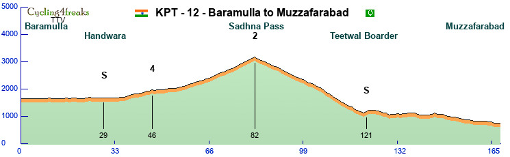
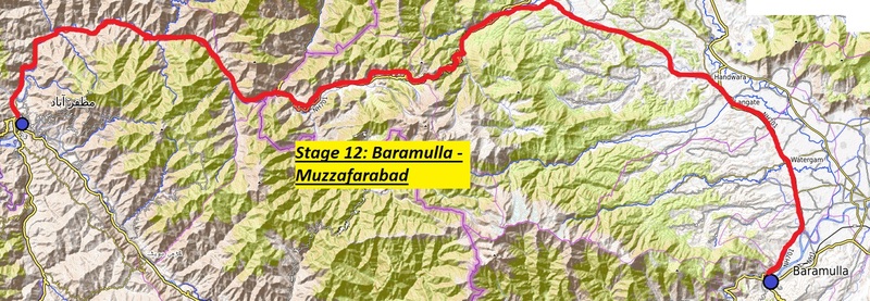
After India and Jammu and Kashmir now also Pakistan comes to its right hosting also the only boardercrossing stage of this tour. As there are unluckily only 2 open boarders between Kashmir and Pakistan we really didnt want to set the government under pressure and decided for the northern one of those in Teetwal.
But lets start from the beginning. The stages starts at yesterdays finish in Baramulla heading out to the north in Handwara where the last secure sprintpoints of this tour for the sprinters can be found. This is because only a few km later (km 36) nearly 50km of climb with 1500hm follow. The question is just how it will be ridden. The first 20km until the riders go onto the National Highway 71 near Kralpora are just slightly hilly and normally not siebable so the organisation also decided to rate the first uphill as a single climb.
The real climb starts then with nearly 1100hm more to go in around 30km. But also here is the point that the first 5 is just 15km from the finish and only 2 km higher then 5 near to the top can be found. So if sprinter teams have a good classics rider they sacrifice for pulling they might be able to keep the distance under control until the top is reached at the Sadhna Pass.
The following 40km until the boarder go straight downhill and already here nearly 50km from the finish we could see a first hint which kind of riders will win today as its till 400hm of downhill to the finish which will slightly favour the classic riders if they have still enough advantage to believe in a coop. The final will anyway be in Muzzafarabad the capitol of the autonomous region of „Azad Kashmir“ and is very well known for a big mixture of spoken languages and lived cultures!
Intermediate Sprints:
KM 29 – Handwara
KM 121 – Teetwal boarder
GPM:
Cat. 4 – Unnamad - KM 46 - 9 KM - 250 hm – 2,8%
Cat. 2 – Sadhna Pass – KM 82 – 26 KM – 1170 hm – 4,5% - Max. 8% (KM 77)
Stage 13 – Chikkar to Islamabad – H.C. Mountain - 188 km – 4380 hm – Mintact at KM: 142 – Stage duration: 117 min
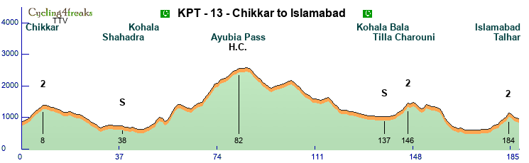

Often last stages of tours are called „Tour d'Honneur“ and there will be a gentleman agreement that the gc is not attacked anymore. But not this time – Here as Pakistan anyway hosts only 1,5 stages it has the honour to host a stage that could wrap the GC around in the last kms with a stage that is clearly one of the hardest of the hole tour.
Starting in the Chikkar valley already the first few km are going uphill over an unnamed pass to reach the Srinagar Highway coming from Muzzafarabad. Maybe already here some weakened riders will pass away and have a hard time to even reach the finish within the time limit. After going down to the Jhelam river valley riders will follow the Srinagar Highway always on the east side of the river which belongs to the autonomous „Azad Kashmir“ territory also competing for an IS at the Shahadra view point before they change sides and enter „real“ Pakistan near Kohala.
Riders directly head into the Ayubia Pass which is even if it contains 2 counterslopes clearly the hardest pass of the day, maybe even of the tour, leading them up to Pakistans biggest skiing territory (1 chairlift, 1 T-bar).
After 40kms of real downhill and 20 more flat km riders will have already passed the last IS of the tour in Kohala Bala and reach out for the last 2 difficulties of the tour.
Even if not going up to the top of Tilla Charouni the extremely hard climb is named after this „house mountain“ of Islamabad. And that tells us already that we are really near to the finish. The riders will downhill with wonderful views on this very young city that was just built in the 1960s to success Karatschi as capitol of Pakistan. As the city itself has no real remarkable point for the finish riders will cross it and then take the Talhar road into the hills over Islamabad where the GC will be decided on a short but steep climb followed by 4 km of light downhill!
And then its time to meet our winners, have a good evening with best wishes for peace and big thanks to the organisation comittees of all those countries that allowed us to be part of that wonderful cometogether!
Intermediate Sprints:
KM 38 – Shahadra
KM 137 – Kohala Bala
GPM:
Cat. 2 – Unnamad - KM 8 - 7 KM - 490 hm – 7,0% - Max. 9% (KM 4 and 5)
Cat. H.C. – Ayubia Pass – KM 82 – 36 KM – 2190 hm – 6,1% - 6,6,10,9,-2,-10,4,11,18,12,8,1,-6,-4,-3,-2,10,3,5,2,11,13,11,13,11,3,10,4,2,6,10,5,4,5 - Max. 18% (KM 57)
Cat. 2 – Tilla Charouni - KM 146 - 5 KM - 490 hm – 9,8% - Max. 11% (KM 146)
Cat. 2 – Talhar - KM 184 - 7 KM - 480 hm – 6,9% - Max. 12% (KM 184)
Introduction
Many of you will know that there is a swelling conflict between India, Pakistan and China called the „Kashmir conflict“.
When India was partitionated in 1947 both India and Pakistan claimed to be the righteous owner of the former princely state „Jammu and Cashmir“.
Moreover china stated that the „Aksai Chin“ should be an integral part of china and therefor it did not accept the boundaries of Jammu and Kashmir while generally standing more or less on the pakistani side.
This conflict escalated into 3 wars between those countries and even more other armed skirmishes.
After pakistani surrender in 1971 the Simla Agreement between Zulfikar Bhutto and Indira Gandhi stated that the conflict should be resolved and that the status quo should be held until a durable peace is established.
Unfortunately also the following 50 years brought no peace but an everlasting conflict resulting in senseless skirmishes, the strenghtening of islamism and violations of human rights.
To stop this horrible spiral of fighting the diplomatic department of Team Trojer Vellau, generally known as the most peaceful cycling team in the world (at least in its own view) invited the heads of all 3 states as well as the kashmir regional government to the teams headquarter in southern tyrol to suggest them an idea that could show that all are interested in peace and friendship.
All 4 parties were immediately enthusiastic of the idea of a road race in the conflict region bringing not only joy to the people but also to be seen as background for further negotations about the future.
While the chinese government said the race couldnt be held in Aksai Chin cause there are no more valuable streets between Kashmir and Aksai Chin they promised to send a delegation to the race which therefor will be held between Indian Capital New Delhi and Pakistans capital Islamabad passing different municipalities including some decisive stages in Kashmir and Jammu.
And so the „KASHMIR PEACE TOUR 2023“ was born.
Teams from all over the C4F world will be invited to contend!
General Information
9 riders per team
13 Stages + 1 Rest Day in total split into:
5 Flat Stages
4 Middle Mountain Stages
3 H.C. Mountain Stages
1 Individual Time Trial
2.060 km in total
158 km per stage (169 km excluding ITT)
29510 hm in total
2270 hm per stage (2369 hm excluding ITT)
101 min average riding time (107 min excluding ITT)
Stage presentation will be the following:
Stage Number – Stage start to stage finish – Stage Type – Stage length – Stage ascent – Mintact at km: xxx – Stage duration: xxx min
Rules for IS and GPM
2 intermediate sprints per stage valued with 6-4-2 points for the first 3 riders and 3,2,1 seconds
The GPM will be categorized and presented as follows:
The start of a climb will normally the first 4+ km, but there may be exceptions like a climb starting with lower percentages directly after a downhill with no flat part in it.
Cat. 4 - >200hm or presenters choice - Name - KM - Length - HM - average steepness
Cat. 3 - >400hm and 5% or over 200hm and 6% - Name - KM - Length - HM - average steepness
Cat. 2 - >600hm and 5% or over 400hm and 6,5% - Name - KM - Length - HM - average steepness - Steepest KM
Cat. 1 - >800hm and 5% or over 600hm and 6,5% - Name - KM - Length - HM - average steepness - Last 10km and Steepest km
HC - >1500 hm and 5% or over 1000hm and 6,5% or Most HM - Name - KM - Length - HM - average steepness - All km starting from the first 4+ and Steepest km
If a climb doesnt fit the xxx hm and 5% criteria it will be classified 1 category lower.
E.g. 1050 hm and 4,5% would be a category 2 climb.
If a climb has special characteristics but does not fit certain criteria its up to the designer to choose another category.
It will be then explained in the stages description.
10,6,4 second on all stages except ITT in the finish!
Stage 1 – New Delhi to Saharanpur – Flat Stage - 173 km – 90 hm – Mintact at KM: 143 – Stage duration: 102 min
The tour starts directly in the heart of New Delhi not only indias capital but a pulsating city with only 250k inhabitants but part of the mega-city of delhi worlds 3rd biggest metropolitan region with over 32 million inhabitants. It was founded in 1911 to follow Kalkutta as capital of british india. On the long way out of New Delhi riders will straight head to the north on flat roads and after leaving New Delhi through mostly uninhabitated places through the little villages of Barnawa and Balwakheri where the 2 intermediate sprints of the day will be the only places where riders heart rate might go up before reaching Saharanpur.
Shaharanpur named after the islamic holy Shah Haran Chishti is an 700000 inhabitants city in the district of Uttar Pradesh and will most likely be a very big invitation for the sprinters.
Intermediate Sprints:
KM 68 – Barnawa
KM 132 – Balwakheri
GPM:
-
Stage 2 – Saharanpur to Maa Ganga Airport – Middle Mountain Stage - 177 km – 2950 hm – Mintact at KM: 132 – Stage duration: 111 min
The second stage starts again in Saharanpur and heads north again. After passing Chutmapur and the pretty small Mohand pass the capitol of the district of Uttarakhand Dehradun a 650000 inhabitants city will be passed where also the second of the intermediate sprints takes part which could also be reachable for sprinters. Afterwards the mountains of this district will be reached with first the big climb up to the Kaphlani pass which is nearly 2200 meters high and has some steep km but is all in all more a flat one. After a downhill back to 1400hm where the riders can get back some power the second pass „Chuliklila“ waits for the riders where the fight for the win will be decided most likely. Or will it be the second long downhill leading our riders to the Tehri River with even a short flat part in the end?
The finish will me then at the field of Maa ganga airport which was built for pilgrims. So maybe some holy help for the riders?
Intermediate Sprints:
KM 24 – Chutmapur
KM 69 – Dehradun
GPM:
Cat. 4 - Mohand Pass - KM 56 - 7 KM - 230 hm - 3,3%
Cat. 1 - Kaphlani Pass - KM 107 - 28 KM - 1420 HM – 5,1% – 14,5,8,7,2,4,-1,5,1,7 - Max. 14% (98)
Cat. 3 - Chulukhila Pass - KM 149 - 18 KM - 740 HM – 4,1%
Stage 3 – Barkot to Herbertpur – Middle Mountain Stage - 157 km – 2420 hm – Mintact at KM: 100 – Stage duration: 107 min
From Maa Ganga its just a short transfer to Barkot also in the Uttar Pradesh District. The 17000 inhabitants city is located on the banks of the Yamuna river. From there the riders will first go to the west in a small downhill part until the first sprint which is located in Khawala. Some km after the Jagmana Pass is awaiting with some steep km but all in all not with big problems for the most riders most likely. What still has to be mentioned that the pass starts very flat and gets steeper in the end so maybe someone still wants to try here to get rid of weaker riders. The next 30km are then down with some uphill splitted by the second IS at Jakhahaddar before the second climb of the day starts. Its again around 600hm but only 3,7% in average thanks to some little downhills and flat parts but still there are enough steeper km where siebs can happen. But the real decision about the stagewin will maybe happen 20km later on the last little climb to the village of Singhori just 50km from the finish. This one has only 2 siebkm but maybe someone tries it or will even hillsprinters or sprinters go the hard and long way and use the following 35km of downhill and 15km of flat to catch up with guys with more mountain? Anyway the end of the stage will be in Herbertpur (yes its called after a Sir Herbert so a remainder of british colionalism but still a very nice place in between flatlands and mountains!)
Intermediate Sprints:
KM 22 – Khawala
KM 61 – Jakhahadar
GPM:
Cat. 3 - Jagmana Pass - KM 40 - 18 KM - 840 hm – 4,7%
Cat. 3 - Kaphlani Pass - KM 85 - 16 KM - 590 HM – 3,7%
Cat. 4 - Singhori - KM 197 - 8 KM - 340 HM – 4,3%
Stage 4 – Chandigarh to Nangal – Flat Stage - 155 km – 1650 hm – Mintact at KM: 125 – Stage duration: 103 min
Chandigarh is an interesting city to start. The million city is not only the municipality of the territories Punjab and Haryana. The city has also been planned by the famous swiss architect Le Corbusier. But there is not so much time so stay there so the riders ride north crossing the boarder to „Himachal Pradesh“ where the first sprint is held in the little city of Baddi. Afterwards the ride continuos further north reaching the first unnamed pass of the day which is long but really not steep and shouldnt cause problems to any of the sprinters. The next 40km are more or less a downhill on narrow streets with some short climbs in it, but as any gradient over 5 is missing it shouldnt really be a problem for sprinters to keep on if they are kept fit – On the way they could also take the second sprint of the day but it will be more likely one for escapers. The real problem for them awaits then in the climb to Swarghat where some hillsprinters or even classic riders could try to split the field. Now there are 50km left for the groups to find together again. After a downhill over nearly 1000hm the mintact will start giving the riders more time to have at least a look at the city of Anandpur one of the most sacred places of Sikhism the 4th biggest world religion. After 30 flat km the riders finally reach Nangal where everything between strong classics with sprint and sprinters with strong flatteam can happen.
Intermediate Sprints:
KM 33 – Baddi
KM 67 – Ram Shar
GPM:
Cat. 4 – Unnamed Pass - KM 51 - 14 KM - 470 hm – 3,4%
Cat. 3 - Swarghat - KM 101 - 9 KM - 540 HM – 6,0%
Stage 5 – Nangal to Palampur – Middle Mountain - 198 km – 3400 hm – Mintact at KM: 156 – Stage duration: 118 min
Nangal will also be the starting place for a hard triple of stages with this one most likely something more for a 85-65 or 75-80 then a 90-50 mountain rider. Before the next day also some brave earlier attacker could be the big winner and part of the peace process. But before we talk to much about our heroes let the cycle speak and present the route. The first 30km parallel to the Gobidi Sagar lake are more or less light hills with always up and down but the sprinters could be able to get points at the first sprint still. But already a little later they might be siebed at the first hill even if it is not categorized but contains a 7. Those that survive it have another chance for sprint points before the real action starts because even if the first pass is only 4km long it gives a good chance to reduce the field already for a strong team.
A last little downhill and flat part is awaiting before the riders reach Harmirpur and therefor also the so called „lower Himalaya“ … guess all riders know what that means. But wait – What most guys wont know is that between the lower and the real Himalaya the roads where built mostly over smaller passes and also in valleys so in fact there are more km to relax at least a little (or to keep the helper advantage with some strong flat and downhill riders) before 70km from the finish the 3 real mountains of the day await.
The first one of them up to Basahi will be clearly the hardest of them with even some 12% in it but as it is still 55km from the finish it is not so sure something big for gc could happen here but maybe a weaker mountain rider without gc chances wants to try his luck here? Only a short downhill is there to relax and then it goes to the city of Jogindernagar which is the terminus of the famous „Kangra Valley narrow gauge railway“. Afterwards the riders first down follow the main road but the small road to the Sukar Khad river which results in the last 2 „sieb km“ just about 30km from the finish before the riders pass Chauntra a Tibetan colony (which might be a hint for the next day). After another little flat and downhill part it goes up the final climb to Palampur which is mostly famous because Dr. Jameson intruced the tea bush there. Now the Kangra tea of Palampur is internationally renowned! Tea could be also something our riders might like after the quite long but not steep climb which favours definitely classics and 80-70s over real mountain riders. The finish is then also more in favour of those as its 3km with -2% gradient.
Intermediate Sprints:
KM 26 – Khuwain
KM 42 – Bangana
GPM:
Cat. 3 – Unnamed Pass - KM 47 - 4 KM - 300 hm – 7,5%
Cat. 4 - Hamirpur - KM 74 - 9 KM - 310 HM – 3,4%
Cat. 3 - Basahi - KM 142 - 12 KM - 680 HM – 5,7%
Cat. 4 - Jogindernagar - KM 162 - 6 KM - 300 HM – 5,0%
Cat. 4 - Palampur - KM 195 - 9 KM - 360 HM – 4,0%
Stage 6 – Palampur to Dharamshala – ITT - 38 km – 1080 hm – Mintact at KM: 1 – Stage duration: 38 min
You heard something about Palampur before and the most of the road is flat so concentrate on the finish of this ITT which will be very decisive in the GC this time. Dharamshala means „house of the pilgrim“ and is one of the most famous cities in india. First the riders will pass „lower dharamshala“ also called Kotwali bazar which is somehow the business center there but also a very poor city. Until here the road is flat before the riders will take the 9km (7km of them steep) to upper Dharamshala which was originally founded as McLeod Ganj a summer residence for the brit emperors. Nowadays this place is much more known for something else. Its the exile of Tendzin Gyatsho the reigning Dalai Lama. Therefor every year thousands of pilgrims come to this sanctuary of Buddhism which is also called „Little Lhasa“. Hopefully riders can enjoy this spiritous ground after a long and steep climb.
Intermediate Sprints:
-
GPM:
Cat. 1 – Little Lhasa - KM 38 - 7 KM - 730 hm – 10,4% - 6,8,11,11,9,13,15 – Max. 15% (Km 38)
Stage 7 – Sihantu to Panchpulla – H.C. Mountain Stage - 141 km – 4440 hm – Mintact at KM: 85 – Stage duration: 103 min
The last stage before reaching the Jammu and Kashmir district starts just 50km away from Dharamshala but the profile is totally different as we see the first of 2 real hard mountain stages of this tour. With the rest day awaiting it will be a question of power left from the hard ITT yesterday which rider will prevail! Starting nordwards from Sihantu a small city the Bholi pass which will not be a big obstacle for most guys is nearly directly awaiting. Afterwards the deepest point of the stage is reached before the first of 2 climbs starts which is harder but not as long as the second one. But before Lahru is very happy to host the first sprint of the day. The now following Chamba Jot pass has been subject to many descriptions as one of the most beautiful places all over the Himalaya … We will just cite here „The complete silence and the sunlight breaking through the clouds to light up the mountains will make you awe and ponder over the beauty of nature“. But the riders will more likely suffer and ache over the steepness of this climb. And dont wonder about „only 5,3%“ as its very unrhytmic to ride! The following 30km will give the riders time to regroup while the pass the second IS of the day in Chamba the small city on the foot of the mountain. Now the riders change direction to the west and follow the steep coast of the ravi river between India and Pakistan to Khabbar where only a smaller mountain is waiting for them but it is still not to underestimate. As this climb is also very unrhytmic (flat until 12%!) because its now only 20km left until the final climb starts! The Panchpulla waterfall that is to be reached lies in a height of nearly 2700 meters and is well known as a natural miracle. But to get there riders will have to climb up a very long climb but at least its by far not as unrhytmic as the Chamba climb but more or less always the same! Lets see if someone will lose much time after the ITT before, if someone even gave away the gc the day before for that stage and then we wish all a happy restday!
Intermediate Sprints:
KM 25 – Lahru
KM 79 – Chamba
GPM:
Cat. 4 – Bholi - KM 13 - 9 KM - 370 hm – 4,1%
Cat. H.C. – Chamba Jot - KM 54 - 31 KM - 1640 HM – 5,3% - 4,5,6,6,6,5,4,12,-1,11,2,5,3,7,5,8,11,4,9,8,7,6,7,5,6,4,6 – Max. 12% (Km 34)
Cat. 3 - Khabbar - KM 97 - 13 KM - 620 HM – 4,8%
Cat. 1 - Panchpulla - KM 141 - 33 KM - 1480 HM – 4,5% - 10,1,0,9,6,5,5,5,5,8 – Max. 10% (Km 132)
REST DAY – REST DAY – REST DAY
Stage 8 – Basohli to Jammu – Flat - 183 km – 830 hm – Mintact at KM: 153 – Stage duration: 96 min
On the rest day the riders were transferred to Basohli a small city directly located on the River Ravi which is actually the boarder between the Union district of Jammu and Kashmir and the rest of India.
First the riders have to ride around the Ranjit Sagar which is a artificial lake for power production and one of the 10 biggest dams in India.
Here the road is also more or less a little up and down culminating in a small pass on the west side which might make some guys attack that want the polka dots but clearly should not be any problem for the sprint teams with nearly 150km more to come. The following downhill brings the riders back to the level of river ravi which will now be followed for around 45km with a IS in the city of Kathua (50000 inhabitants but not much more to know about it). The next 30km will be ridden west directly along the boarder to Pakistan before turning away from it again. The riders will then reach the National Highway A1 which they follow for the last 50km of this stage. First the last IS in Samba (which has nothing to do with famous Sambal Oelek!) is there to compete for. Afterwards the riders directly reach out to Jammu which is the second biggest (around 500000 inhabitants) city of Jammu and Kashmir and has always been since the times of the Maharadschas and still is the „winter residence“ of the Jammu and Kashmir government.
Intermediate Sprints:
KM 76 – Kathua
KM 150 – Samba
GPM:
Cat. 4 – Unnamed - KM 36 - 5 KM - 210 hm – 4,2%
Stage 9 – Udamphur to Panila – H.C. Mountain - 135 km – 3190 hm – Mintact at KM: 96 – Stage duration: 97 min
The sprinters had their fun so the mountaineers should have and its maybe the last chance for them to gain bigger time differences, while the following stages will all be hard but clearly nothing for someone who needs minutes. The city of Udhampur where the stage starts is mostly known as command of northern forces of Indias military, so nothing really lovely. Reason enough to directly leave the city to the north and have a first IS in Chenani. We will see if sprinters are still there as a little climb directly before the IS might have siebed them out already. Riders could now take the easy way through the „Dr. Syama Prasad Mookerjee Tunnel“ (with over 9km the longest road tunnel all over india!) but as it is a mountain stage no way so they will have to take the long and hard climb to the Patnitop pass on the former national highway. Its characteristic might be more for a strong team gaining an helper advantage then a big attack though as it is really long but not steep at all with max. a 7% in it. The following 50km will be a nearly perfect downhill to repower and regroup first steeper and then after a short counterslope more flattish alongside the Chenab river, also passing Chandarkot there were the last IS of the day will happen.
In Ramban the main road will be left and after only a few km alongside Chenab river the road turns sharply north and directly into the mountains for 40km of climbing action. Still those 40km are more or less divided into 2 parts. First there are 11 pretty unrhytmic km through a narrow valley to Digdaal. There the valley then widens up a little with some nearly flat km before the last 23km and over 1100hm await the riders. Here we might have a first „predecision“ of the tour winner but at least 2 more chances to switch the gc around wait still! Attention as it is in total still a 1600hm climb it will be categorized as 1 not as 2 so Polka dot riders can be happy!
Intermediate Sprints:
KM 21 – Chenani
KM 85 – Chandarkot
GPM:
Cat. 3 – Patnitop Pass - KM 43 - 23 KM - 870 hm – 3,8%
Cat. 3 – Digdaal – KM 106 – 11 KM – 470 hm – 4,3%
Cat. 1 – Panila – KM 135 – 23 KM – 1110 hm – 4,8% - 5,3,7,8,3,2,6,6,-1,7 – Max. 10% (KM 121)
Stage 10 – Anantnag to Srinagar – Flat - 188 km – 510 hm – Mintact at KM: 158 – Stage duration: 109 min
The last of 3 clear sprinter stages is waiting. After the only longer transfer of this tour (around 3.5 hours) to Anantnag not only 3rd biggest city of Jammu and Kashmir, economic centre of the Kashmir valley but also the seat of the university of Kashmir the ride starts always along the Highway to Srinagar which is clearly the most important city all over Jammu and Kashmir beeing its capitol and summer residence of the government, but also more as double as big as Jammu and the oldest known city in the hole district founded in the 3rd century B.C. by King Ashoka . Therefore it deserves to have an IS before the road continues north by northwest and going around the Wular / Wolar lake which is one of the biggest fresh water lakes all over south asia with 189km² of square. Here around the lake also the only 2 very small possibilites to get rid of sprinters wait at km 100 and km 128 with single 5s. After 12 more kms Sopore is reached where the Jhelam river leaves the lake with an IS and then the road heads back directly to Srinagar which is the only city beeing – due to its importance for Jammu and Kashmir – 3 times visited at this tour hosting IS, stage finish and stage start the next day.
Intermediate Sprints:
KM 56 – Srinagar
KM 140 – Sopore
GPM:
Stage 11 – Srinagar to Baramulla – Middle Mountain – 159 km – 2690 hm – Mintact at KM: 103 – Stage duration: 109 min
After sprinters had their fun yesterday today it could be the big chance for riders that havent fulfilled their goals yet e.g. some brave hillstrong escapers! Or will a strong classics team give full throttle today risking to be to weakened to keep the sprinters away a last time tomorrow?
Starting in Srinagar as we announced the route first goes flat through the suburbs into Badgam which is also a part of Srinagar still with IS nr. 1 of the day. Afterwards the road starts rising slowly for the first time to Mujpather where we will the first fight for the dots. This climb is also as we know it from stages before pretty long but not so steep that the field will totally explode which will be even more favourable as the only siebkms are directly at the start and then 2km from the top. Next there will not be a real downhill but just some km and a longer flat part before the real downhill starts directly after the IS at Khag. Riders could now take the direct way to the Gulmarg road but unfortunately that would lead to an disqualification because the stage really would have been much to short and easy then. So they will after reaching the valley again take a sharp turn to the west and head up to Hachlara Kol named after a rivers source there. This climb is stronger especially in the second part and might force some teams into higher tempo or a early attack.
Riders will have again some km to regroup before the biggest climb of the day awaits – reaching the Gulmarg skiing station (valley station) which is one of the most famous resorts all over asia with great freeriding possibilities up to nearly 4000meters above sea level at its top station and no groomed slopes at the main gondola. But thats not what riders are here for … the will have much less to do on the long climb that is pretty steady around 4-5% interrupted by two steeper parts (max. 7%). After riding round the Gulmarg golf course the route heads steady downhill to Baramulla but in between there is another little hill awaiting that will bring the final decision. But as it is followed by some more or less flat km and the downhill it wont be enough for mountain guys normally … So in Baramulla the district municipality located at the Jhelam river it will be escapers or classics to be happy we assume!
Intermediate Sprints:
KM 42 – Badgam
KM 62 – Khag
GPM:
Cat. 3 – Mujpather - KM 42 - 17 KM - 630 hm – 3,7%
Cat. 2 – Hachlara Kol – KM 85 – 12 KM – 620 hm – 5,2% - Max. 9% (KM 83 and 84)
Cat. 2 – Gulmarg – KM 122 – 20 KM – 900 hm – 4,5% - Max. 7% (KM 111 and 116)
Cat. 4 – Unnamed – KM 122 – 4 KM – 220 hm – 5,5%
Stage 12 – Baramulla to Muzzafarabad – Flat - 168 km – 1880 hm – Mintact at KM: 121 – Stage duration: 107 min
After India and Jammu and Kashmir now also Pakistan comes to its right hosting also the only boardercrossing stage of this tour. As there are unluckily only 2 open boarders between Kashmir and Pakistan we really didnt want to set the government under pressure and decided for the northern one of those in Teetwal.
But lets start from the beginning. The stages starts at yesterdays finish in Baramulla heading out to the north in Handwara where the last secure sprintpoints of this tour for the sprinters can be found. This is because only a few km later (km 36) nearly 50km of climb with 1500hm follow. The question is just how it will be ridden. The first 20km until the riders go onto the National Highway 71 near Kralpora are just slightly hilly and normally not siebable so the organisation also decided to rate the first uphill as a single climb.
The real climb starts then with nearly 1100hm more to go in around 30km. But also here is the point that the first 5 is just 15km from the finish and only 2 km higher then 5 near to the top can be found. So if sprinter teams have a good classics rider they sacrifice for pulling they might be able to keep the distance under control until the top is reached at the Sadhna Pass.
The following 40km until the boarder go straight downhill and already here nearly 50km from the finish we could see a first hint which kind of riders will win today as its till 400hm of downhill to the finish which will slightly favour the classic riders if they have still enough advantage to believe in a coop. The final will anyway be in Muzzafarabad the capitol of the autonomous region of „Azad Kashmir“ and is very well known for a big mixture of spoken languages and lived cultures!
Intermediate Sprints:
KM 29 – Handwara
KM 121 – Teetwal boarder
GPM:
Cat. 4 – Unnamad - KM 46 - 9 KM - 250 hm – 2,8%
Cat. 2 – Sadhna Pass – KM 82 – 26 KM – 1170 hm – 4,5% - Max. 8% (KM 77)
Stage 13 – Chikkar to Islamabad – H.C. Mountain - 188 km – 4380 hm – Mintact at KM: 142 – Stage duration: 117 min
Often last stages of tours are called „Tour d'Honneur“ and there will be a gentleman agreement that the gc is not attacked anymore. But not this time – Here as Pakistan anyway hosts only 1,5 stages it has the honour to host a stage that could wrap the GC around in the last kms with a stage that is clearly one of the hardest of the hole tour.
Starting in the Chikkar valley already the first few km are going uphill over an unnamed pass to reach the Srinagar Highway coming from Muzzafarabad. Maybe already here some weakened riders will pass away and have a hard time to even reach the finish within the time limit. After going down to the Jhelam river valley riders will follow the Srinagar Highway always on the east side of the river which belongs to the autonomous „Azad Kashmir“ territory also competing for an IS at the Shahadra view point before they change sides and enter „real“ Pakistan near Kohala.
Riders directly head into the Ayubia Pass which is even if it contains 2 counterslopes clearly the hardest pass of the day, maybe even of the tour, leading them up to Pakistans biggest skiing territory (1 chairlift, 1 T-bar).
After 40kms of real downhill and 20 more flat km riders will have already passed the last IS of the tour in Kohala Bala and reach out for the last 2 difficulties of the tour.
Even if not going up to the top of Tilla Charouni the extremely hard climb is named after this „house mountain“ of Islamabad. And that tells us already that we are really near to the finish. The riders will downhill with wonderful views on this very young city that was just built in the 1960s to success Karatschi as capitol of Pakistan. As the city itself has no real remarkable point for the finish riders will cross it and then take the Talhar road into the hills over Islamabad where the GC will be decided on a short but steep climb followed by 4 km of light downhill!
And then its time to meet our winners, have a good evening with best wishes for peace and big thanks to the organisation comittees of all those countries that allowed us to be part of that wonderful cometogether!
Intermediate Sprints:
KM 38 – Shahadra
KM 137 – Kohala Bala
GPM:
Cat. 2 – Unnamad - KM 8 - 7 KM - 490 hm – 7,0% - Max. 9% (KM 4 and 5)
Cat. H.C. – Ayubia Pass – KM 82 – 36 KM – 2190 hm – 6,1% - 6,6,10,9,-2,-10,4,11,18,12,8,1,-6,-4,-3,-2,10,3,5,2,11,13,11,13,11,3,10,4,2,6,10,5,4,5 - Max. 18% (KM 57)
Cat. 2 – Tilla Charouni - KM 146 - 5 KM - 490 hm – 9,8% - Max. 11% (KM 146)
Cat. 2 – Talhar - KM 184 - 7 KM - 480 hm – 6,9% - Max. 12% (KM 184)
Re: December Tour 2023 - Presentation
Tamil Nadu&Kerala International Bicycle Race
Our entry for this years December Tour is in c4f starved southern India. They really love c4f there, but never had a December Tour, wherever we went during our reconnaissance trips, we were immediately recognized, you're Big Donkey! Or RKL? The designer, please, bring the December Tour to us! So while originally we had already a rough plan for a December Tour in another place, this was more for future ideas, we decided to make Southern India happy immediately.
As almost always for RKL Dec tours, this one on paper is for a climber with TT. But we don't play on paper, so...
5 flat stages
3 middle mountain stages.
4 HC stages,
1 TT, with some hills.
Here a map, as great as RKL is in desiging tours, his map creation skills need to be worked on. No numbers or anything, we start in the north east, Chennai, which isn't readable... bah. Black dots are transfers, you'll figure it out. Eventually.

9 riders
Mintact 30 km unless otherwise mentioned.
1 IS per stage
But let's go to the stages:
Stage 1 Chennai-Tiruvannamalai
190 km
Flat stage
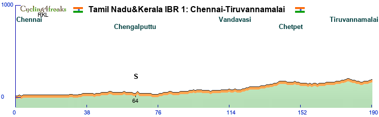
The start is in Chennai, from there we head southeast and reach Tiruvannamalai after 190 km.
A completely flat stage. Not much to say about it really, the finish is +1. No GPM, the steepest km is km 65 at 2%. That it, a flat stage.
So let's concentrate on Chennai and Tiruvannamalai instead.
Chennai, state capital and biggest city of Tamil Nadu, formerly known as Madras, nowadays a modern city, 12 millions inhabitants. One of the economic centers of India, the center of its automotive industry and strong IT technology too.
Tiruvannamalai is much smaller, the metro area has only 400'000 inhabitants. It lies at the foot of an isolated hill, Arunachala, and has a big temple complex, Arunachalesvara Temple.
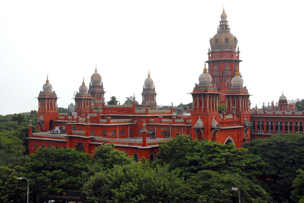
Madras High Court. An example of Indo-Saracen architecture, meaning combining Indian, more specifically Mughal architecture with western architecture. We'll pass close to the High Court in the first kms of the race. Actually around the first km.
Stage 2: Tiruvannamalai-Salem
209 km
Hilly stage
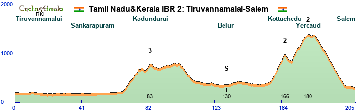
The first middle mountain stage. After 65 flat km, the first climb of the Tour. We enter the Kalvarayan Hills from the east, a longish but not too difficult climb, there's only 3 km at 6% or more. The real difficulties start later, at km 158, where we start the climb to the Shevaroy Hills, to Yercaud, located 1370 meters above sea level. The climb is in 2 steps the first 1 9 km to a village called Kottachedu 970 meters above sea level after a 4 km downhill we tackle the second part, another 10km up to Yercaud. but only 5 km are above 6%, it's 6 in the first step. On top, after 2 km at 3% we have a very short flat section, then the downhill followed by another flat km. This should clearly be too much flat for the climbers, so strong classics should get this one.
Not much to say about the finishing city, Salem, 5th largest urban agglomeration and 3rd largest metropolitan area in Tamil Nadu, but doesn't really seem to have any special attractions. Big textile industry, you can buy new jerseys for your team there I guess.
The Shevaroy Hills are used for recreation, cooler weather, so popular, but they don't seem especially picturesque, at least RKL couldn't find any convincing pictures on wikipedia (where for simplicity's sake he steals his pictures) Coffee and citrus fruits are grown up there.

The first of many temples, the Arunachalam temple in Tiruvannamalai mentioned in the presentation of stage 1. Although finally you won't get to see that many temples in this presentation.
Stage 3: Salem-Top Sengattupatti
160 km
mountain stage
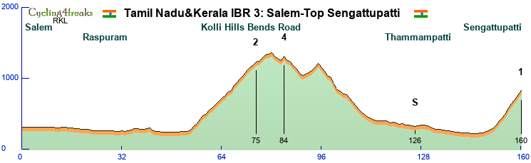
The first mountain stage, so we should get the third new leader today. The stage is not too difficult, but as an early mountain stage it's not supposed to decide the Tour. We head south from Salem and after a basically flat 54 km, the first difficulty of the day starts. The Kolli Hills Bend road. 70 hairpins up to 1200m above sea level, so almost 1000 meters altitude gain. But while the road is spectacular, it isn't overly difficult, we have only 4 km at 6% or more, it takes us 21 km for 950 meters altitude gain. We cross the Kolli Hills, go down north, head back south, and finish the stage in the Pachamalai Hills. This road has switchbacks too, 12 if we counted correctly, but is steeper, 9km, 540m altitude gain. 5 6 4 6 8 6 6 6 7. We'll finish in Top Sengattupatti, After today's stage the GC should already look slightly clearer, from now on the stage winner won't automatically be fighting for the leaders jersey anymore normally.

The 34th of 70 hairpin on the way to Solakkadu. As you can see it's not a very steep road, spectacular yes, mabe not this picture, look for better ones yourself.
Stage 4: Tiruchirappalli-Coimbatore
202 km
flat stage
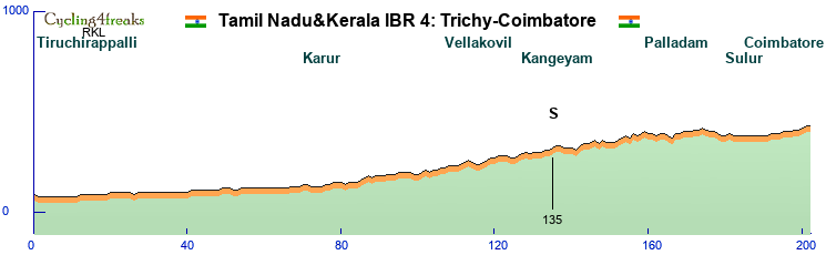
For the start of the 4th stage we move around 80 km south and start in in Trichy, as Tiruchirappalli is thankfully still often called. Tiruchirappalli would have made the name for the stage too long. Called Trichinopoly by the English during colonial times, the official name changed to Tiruchirappalli, but people usually refer to it as Trichy or Tiruchi. Most livable city in Tamil Nadu, close to 1 million inhabitants. Pretty much in the geographic center of Tamil Nadu. Famous for the Sri Ranganathaswamy Temple just outside the city and the Rock Fort, a fortified 3.8 billion years old rock with 2 temples in it/on it.
Coimbatore, the second largest city of Tamil Nadu is where we finish today. On the western edge of Tamil Nadu, with the western Ghats to the north and west. Textile industry, engineering.
Oh, the race? It's flat. We start at 70 meters and finish at 420 above sea level, last km is a 0. At 202 km it's another rather long sprint stage, but after recovering for 2 days the sprinter teams normally should be up for it. An important stage for the points jersey, not for the GC.
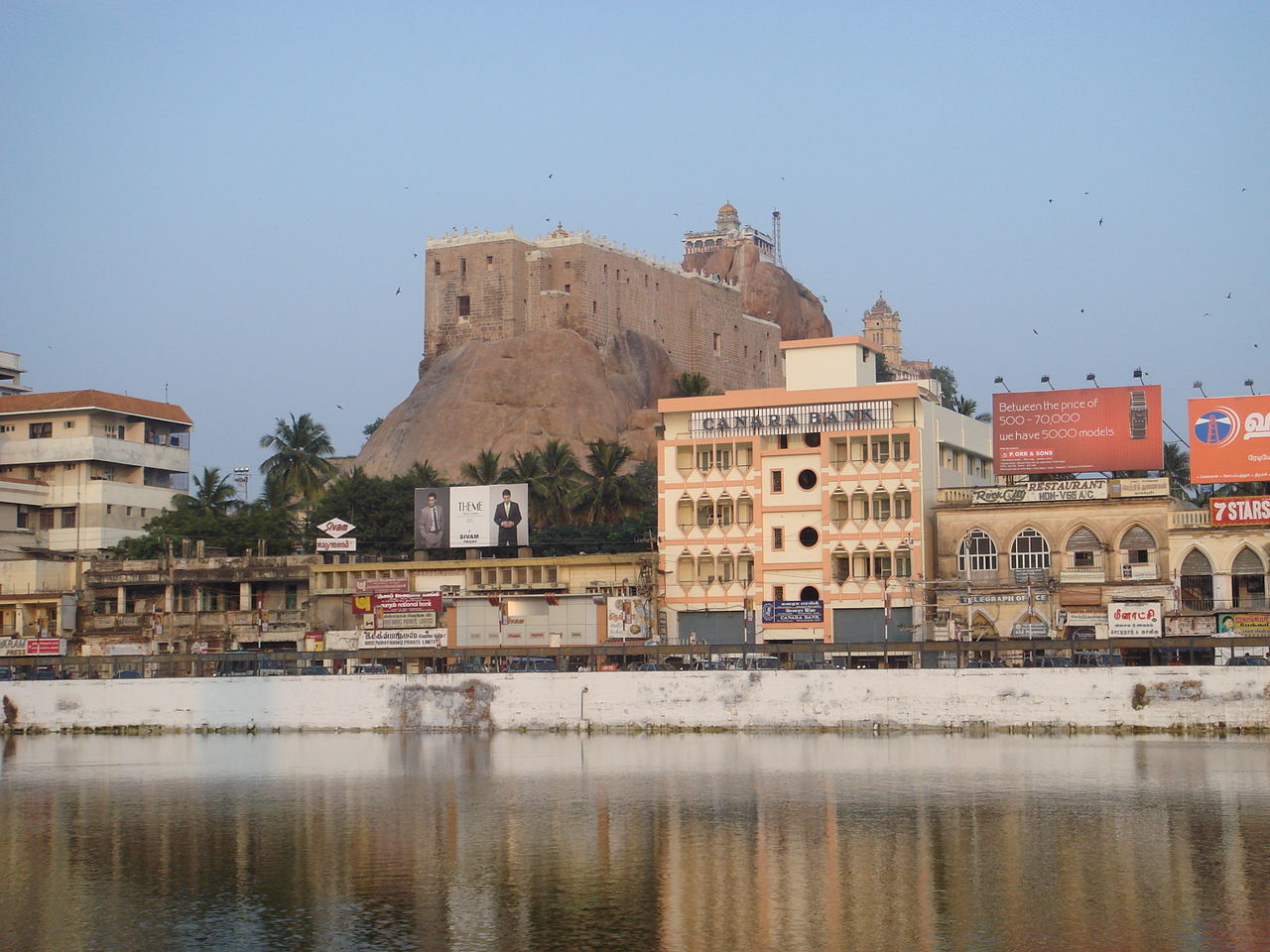
The rock fort in Trichy.
Stage 5: Coimbatore-Kotagiri
191 km
Mountain
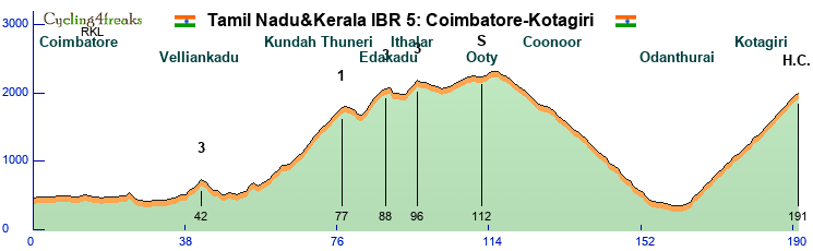
The second mountain stage of the Tour, and this one is much more difficult. From Coimbatore we head north towards the Nilgiri mountains. A first small hill at km 24 won't be hard enough to split the peloton, the next one, a 4km climb at km 42 can, but shouldn't play a role in the outcome of the stage. Serious stuff begins at km 54, where the irregular, 24km long 1200 altitude gain climb to Kundha Thuneri starts. Short downhill, followed by another 2 climbs, 6 and 3 km long, with a combined 8 km at over 6%. We have a 20 km flatter section, still hilly, but not selective going through Ooty, before we hit the long downhill, through Coonoor to Odanthurai. There we turn back north for the long final climb, 29 km from the moment it starts, 27 from the first km over 6%, 1650 meters up in total. Harder km mixed with easier ones, the last 10 km 7 6 6 6 7 6 7 6 7 4. Here a strong team will be important, not only for the earlier cat 1 (+ double 3) climb, but also for the long final climb, where an isolated leader will have difficulties reacting to all attacks himself. Or tire himself out if he tries on his own early. Still, normally easier to make differences here than on stage 3, so the GC should be clearer again. And the wearer of the leader's jersey can expect to keep it until stage 10.
We'll keep the tourist info short this time, Ooty, Coonoor, Kotagiri, all hill stations, cooler weather, popular with the English but also with Indians nowadays.

The Nilgiri mountain railway, going through Coonoor to Ooty.
Stage 6: Ooty-Kozhikode
172 km
flat
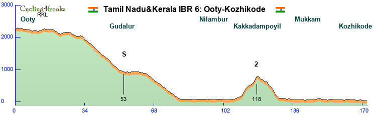
The third sprint stage, and this one looks good for hill sprinters. A slighly hilly start, but nothing over 5%, then a first downhill to Gudalur, where the IS of the day is located. Then the second part of the downhill, into Kerala. At around km 67 we'll cross into Kerala. The first difficulty in Kerala probably won't be popular with sprinters. A 7 km climb, 12 11 7 4 3 9 15, category 2 at km 118. From km 130 on then it's flat, but it's doubtful that these slighly over 40 km will be enough for flat sprinters to come back, they risk losing quite a bit on that hill. Lask km a 0, expectation is hill sprinters, but the flat ones are welcome to prove the organizing committee wrong. A very important stage for green.
Today we start in Ooty, as mentioned before, one of many hill stations, but this one is called the "Queen of the Western Ghats". So the most famous one of them all.?There's a railway going up to Ooty, as you saw in the picture of the previous day, but nowadays it's mostly a tourist attraction. Ooty is also often associated with tea, but actually most of it comes from Coonoor, Kotagiri or the surroundings of Ooty, Ooty itself is a bit too high up for tea plantations, they are at lower altitude. Ooty's official name is Udhagamandalam, but seldom used in daily conversation it seems.
Kozhikode, our first stop in Kerala, was known as Calicut during colonial times. An important port, on the Arabian sea, which we reach today, Used to be the most important port on the Malabar Coast, the center of the spice trade, they even traded with Rome in antiquity. In the 16th century when the Portuguese showed up, Kozhikode's downfall began, it lost it's predominant status within a century, being overtaken by its historic rival further south, Kochi.

View from the road to Gudalur
Rest day:
We will transfer from Kozhikode to Thiruvananthapuram. Thiruvananthapuram, the capital of Kerala. A mouthful, used to be known as Trivandrum, the colonial anglized name. c4f isn't made for Indian cities, too long for the title of the stage, so we had to cut the empty space between the : and the T. We proposed Trivandrum, but were shouted down. A hilly city, but not hilly enough to count as hilly in c4f.

Stage 7: Thiruvananthapuram-Erumely
197 km
Mintact at 152km
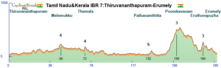
A hilly stage, an escape stage? With the long flat approach to the difficulties of the day it might be difficult to control a group. It's slightly hilly for much of the first part too, but only 2 short climbs that might put some riders into difficulty, the 2 cat 4, 6% for one, 9% for the other.
The final starts at km 153 with a 7 km climb to the beginning of the Poomkavanam forest, if that's what it's called. 7 6 1 6 6 4 6, a borderline cat 3 climb, almost cat 2. After 14 flatish/downhill km, in which we lose 100 meters the real downhill starts, just to be followed by the final difficulty of the day 9 7. 13 km to the end, down to Erumely, where the last km will be on a flat road.
Erumely should be pretty full at this time of the year. It's on the pilgrim way to Sabarimal temple, and the pilgrimage season is in December and January. The whole project might fail because of this, lack of accommodation. Otherwise a small town, 40'000 people. (that includes the surroundings, the center for sure is much smaller)

The forest road near Erumely, well, somewhere in the region although we don't use this exact road, should look similar.
Stage 8: Erumely-Kochi
131 km
flat
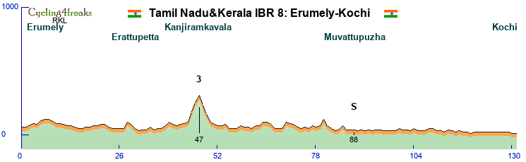
The fourth sprint stage, a short one, only 131 km. There is one difficulty on the day, a climb shortly before Muttam, tops out at 300m at Kanjiramkavala. 8 7 6, 3 km long, After that there's 2 more km at 5%, at km 70 and 80. So normally here the sprinters should have enough firepower to get the hill sprinters back, but depending on the composition of the field, it might be worth a try. A win for hill sprinters here would definitely eliminate flat sprinters from the fight for the points jersey. With stage 6 in the bag normally, they still have chance to win it even if this ends in a bunch sprint.
Kochi, known as Cochin before, now is the biggest city in Kerala, as well as the financial, commercial and industrial center. It long played second fiddle to Kozhikode, got protection from the Chinese (during the short time as a maritime power, before they decided to stop that completely, but that's another story) in the early 15th century protection from attacks by Kozhikode, then when the Portuguese arrived in the late 15th early 16th century Kochi sided with them. After that came the Dutch, then the English and now Kochi is the most important port and city on the Malabar Coast.

Nightview of Marine Drive in Kochi, where the finish of the stage will be, so the evening people don't need to worry, there's light!
Stage 9: Kochi-Kattappana
204km
Hilly
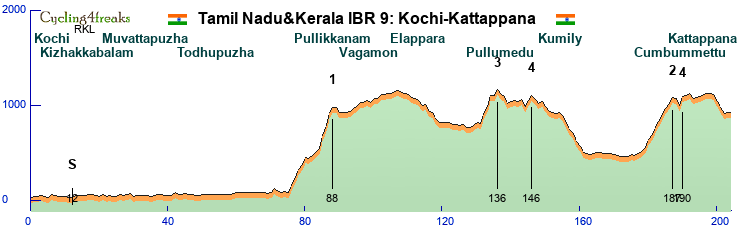
With the 3rd and last middle mountain stage the GC fight resumes. The first of 4 GC stages, being a middle mountain stage it won't necessarily result in GC action, but it could. GC team better be alert anyway. It starts easily, after 12km already there's the IS of the day, tempting the teams that want points for the points jersey. After that it stays flat until 76, where the first and hardest climb of the day starts. Back to the Western Ghats. The climb is in 2 steps, the first one gaining 360 meters in 5 km, one km down, 3 km at 3 3 5, the 13 11 13 7 to reach 960 meters. The teams will then have time to reorganize a bit, no difficulty until a 5 km climb topping out at km 136, there's a flat km in the climb, 9 9 11 0 7. 10 km later a 6 5 climb to some shops on top of the hill, called Odamedu probably. Down to Kumily, where we cross the border in Tamil Nadu again. Downhill followed by the climb to Cumbummettu, where at km 187 we cross back into Kerala. The climb is 8 km long 520 meters up. After a short flat-downhill, the last climb of the day, one short steep km up to Kuzhitolu temple. A very narrow but paved road. From there it's flat, with 4 downhill km at 5% or more until the finish in Kattappana. With a HC stage coming, and the long approach, not an easy stage to control, not for GC teams nor for team that only target the stage.
All is already said about Kochi, so Kattappana: Located in the Cardamon Hills, surrounded by hills, Cardamon and black pepper plantation, it has lately developed into a regional center.

The bus station in Kattappana, for those riders that had enough and want to leave by bus.
Stage 10: Kattappana-Munnar
136 km
HC
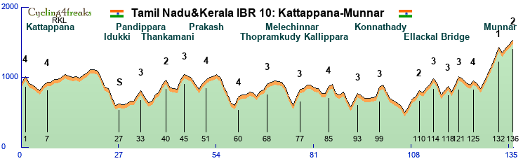
The queen stage. Stage 5 has more climbing, but is significantly longer, here it's packed into 136 km. Lots of small steep climbs, dangerous downhills. We start with a 8% climb to set the tone for the stage. Another 7 5% combination soon after, then the easy part of the stage starts. The IS this time is there for hill sprinters to take, if they want to control until km 27. After that the serious things start. The middle part of the stage, basically from km 32 to 106 is filled with small 1-2 km climbs, many of them with at least 1 km over 10%. Only longer climb is at km 40, 4 km, 3 of which over 6%. At km 106 we reach the lowest point of todays stage, 470 meters. From there the final starts 7 more GPMs, 17 of the last 30 km are at 6% or more, 6 downhill 6% or more. Flattest km are 3 km at -3%. The last climb is in 2 steps, the first one the hardest climb of the day, 9 11 13 12 14. After 1 km downhill at -8%, the last 3 km are 7 5 6. The steep 5 km climb of course risks castrating the race a bit, having such a wall at the end will encourage climbers to wait for that, but earlier attacks are possible too, always depending on the composition of the group of course.
Munnar, tea country. Like a bit everywhere in the hills of course. It's near the highest mountain in South India, Anamudi, at 2695 meters actually the highest mountain in India that is not in the Himalaya.

Tea....
Stage 11: Munnar-Top station
34 km
TT
Mintact from km 1
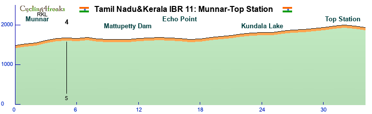
After the short, intense, hard HC stage the preceding day, today regeneration and TT skill will be necessary. We start in Munnar at 1460 altitude, finish in Top Station at 1900, climbing up to 1960 2 km before the finish. But we think (hope?) the TT should still be won by a TT rider, and not a GC rider. There's a km at 6% and one at 5% in the early climb, after that it's never more than 4%. Lots of +2 and +3. And then the last 2 km slight downhill, -4 -2. Might be too hard for pure TT specialists, but TT guys with some mountain capabilities, 60 should manage to stay ahead of the GC guys.
As for the GC, today probably the decisive day. 34 km is plenty to make big differences. Here the climbers with strong TTs will probably finally take command of the race, until now the climbers without TT should normally have been ahead in GC, the question is if they managed to build a big enough advantage.
Top Station is called Top Station because it used to be the top station of a ropeway. There used to be a railway from Munnar to Top Station, then from there a ropeway brought the tea down to the Valley. It's the lowest point in the crest there, so that's why it was used. Top Station is also in Tamil Nadu, just. We cross leave Kerala just 2 km before the finish. Since travelers from Tamil Nadu have to take a big detour through Kerala to reach this tourist destination with amazing views, in 2017 there were plans to build a road up where the ropeway used to be, thus cutting the journey by hours. Another possibility to reach Top Station would be from Kodaikanal, where we finish our stage tomorrow. But there's a national park in between, protected species, only dirt roads in part, so we didn't get permission from the authorities to go through there.

A cycling fan enjoying the view to the Valley from Top Station, while patiently waiting for c4f to visit.
Stage 12: Dindigul-Kodaikanal
155 km
HC stage
mintact from km 108
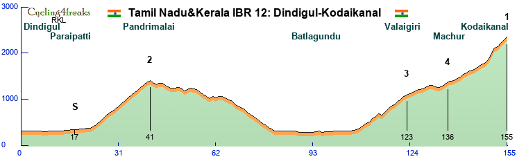
We thought the GC was decided yesterday? Most likely it was, but one last chance to change the GC. The 4th and final GC stage. We start in Dindigul, in the east of the Palani Hills, and start climbing after 24 flat km. At km 17 the intermediate, once again placed early, once again teams still in the fight for the points jersey might consider giving it a go. The first climb tops out at km 41 lots of 5 6 7, not very steep. A hilly downhill until 65, there the downhill back to the plain starts. Km 82-107 then are in the plain, the final climb starts at 108, with a 4. . A first step 7 km long, 3 km at 6% or more, a flat/downhill section near a viewpoint for some waterfalls, followed by a 8km steeper section again. Then it's nothing above 6%, with the exception of a km at 136. The climb continues being shallow, max 5 until km 149. A 6%. Km 150 we decide to leave the main road and instead go up through Kodaikanal with the direttissima, 14-11%, a 4% to reach the lake at Kodaikanal, then we climb above the center towards the Kodaikanal solar Observatory, 7 7 6.
Not a stage that looks easy to make up a lot of time, it's the last 7 km that most likely will decide the stage, and the GC too, if that one is still in play at this point.
Kodaikanal is... surprisingly another hill station. The princess of hill stations, seems all of them have rather annoying nicknames. Munnar is the Kashmir of South India At 2200 meters pretty high up, 36'000 inhabitants, tourism the main industry. Surpringly crowded in pictures, lots of cool steep roads in the northern part across a river, unfortunately that would have given us 1 or 2 flat km, so we stick to the finish near the Observatory. Somehow of all the hill stations the one the RKL would like to visit first.

The entrance to Kodaikanal, you see the main road where we take the direttissima.
Stage 13: Kodaikanal-Madurai
121 km
flat
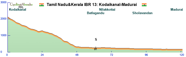
We finish like we started, with a stage for sprinters. Down from Kodaikanal and flat into Madurai. The downhill to Batlagandu is the same as the climb yesterday, except the first km where we took the shortcut yesterday. The percentages look differently, that's because the point of calculation was different. And because we didn't bother to retry and replot the downhill x times like we did for the climb. The downhill ends at km 47, after that it's lots of 0, never more than -1 down. A short probably intense sprinter stage, which favors sprinters with flat obviously. If the points jersey isnt' decided yet, it will be decided here. If the GC isn't decided yet, it won't be decided here either, that would mean that the Tamil Nadu&Kerala International Bicycle Race hasn't been ridden.
Now we had such a nice finish to the presentation, and we only remember now that we still have to present Madurai. Have to because Madurai is the cultural center of Tamil Nadu, a city with a long history, first mentioned 300 BC. And as cultural center it clearly deserves to welcome the final stage of this Tour.

Menaakshi Temple, The city is actually built around this and Koodal Azhagar temple.
Our entry for this years December Tour is in c4f starved southern India. They really love c4f there, but never had a December Tour, wherever we went during our reconnaissance trips, we were immediately recognized, you're Big Donkey! Or RKL? The designer, please, bring the December Tour to us! So while originally we had already a rough plan for a December Tour in another place, this was more for future ideas, we decided to make Southern India happy immediately.
As almost always for RKL Dec tours, this one on paper is for a climber with TT. But we don't play on paper, so...
5 flat stages
3 middle mountain stages.
4 HC stages,
1 TT, with some hills.
Here a map, as great as RKL is in desiging tours, his map creation skills need to be worked on. No numbers or anything, we start in the north east, Chennai, which isn't readable... bah. Black dots are transfers, you'll figure it out. Eventually.
9 riders
Mintact 30 km unless otherwise mentioned.
1 IS per stage
But let's go to the stages:
Stage 1 Chennai-Tiruvannamalai
190 km
Flat stage
The start is in Chennai, from there we head southeast and reach Tiruvannamalai after 190 km.
A completely flat stage. Not much to say about it really, the finish is +1. No GPM, the steepest km is km 65 at 2%. That it, a flat stage.
So let's concentrate on Chennai and Tiruvannamalai instead.
Chennai, state capital and biggest city of Tamil Nadu, formerly known as Madras, nowadays a modern city, 12 millions inhabitants. One of the economic centers of India, the center of its automotive industry and strong IT technology too.
Tiruvannamalai is much smaller, the metro area has only 400'000 inhabitants. It lies at the foot of an isolated hill, Arunachala, and has a big temple complex, Arunachalesvara Temple.
Madras High Court. An example of Indo-Saracen architecture, meaning combining Indian, more specifically Mughal architecture with western architecture. We'll pass close to the High Court in the first kms of the race. Actually around the first km.
Stage 2: Tiruvannamalai-Salem
209 km
Hilly stage
The first middle mountain stage. After 65 flat km, the first climb of the Tour. We enter the Kalvarayan Hills from the east, a longish but not too difficult climb, there's only 3 km at 6% or more. The real difficulties start later, at km 158, where we start the climb to the Shevaroy Hills, to Yercaud, located 1370 meters above sea level. The climb is in 2 steps the first 1 9 km to a village called Kottachedu 970 meters above sea level after a 4 km downhill we tackle the second part, another 10km up to Yercaud. but only 5 km are above 6%, it's 6 in the first step. On top, after 2 km at 3% we have a very short flat section, then the downhill followed by another flat km. This should clearly be too much flat for the climbers, so strong classics should get this one.
Not much to say about the finishing city, Salem, 5th largest urban agglomeration and 3rd largest metropolitan area in Tamil Nadu, but doesn't really seem to have any special attractions. Big textile industry, you can buy new jerseys for your team there I guess.
The Shevaroy Hills are used for recreation, cooler weather, so popular, but they don't seem especially picturesque, at least RKL couldn't find any convincing pictures on wikipedia (where for simplicity's sake he steals his pictures) Coffee and citrus fruits are grown up there.
The first of many temples, the Arunachalam temple in Tiruvannamalai mentioned in the presentation of stage 1. Although finally you won't get to see that many temples in this presentation.
Stage 3: Salem-Top Sengattupatti
160 km
mountain stage
The first mountain stage, so we should get the third new leader today. The stage is not too difficult, but as an early mountain stage it's not supposed to decide the Tour. We head south from Salem and after a basically flat 54 km, the first difficulty of the day starts. The Kolli Hills Bend road. 70 hairpins up to 1200m above sea level, so almost 1000 meters altitude gain. But while the road is spectacular, it isn't overly difficult, we have only 4 km at 6% or more, it takes us 21 km for 950 meters altitude gain. We cross the Kolli Hills, go down north, head back south, and finish the stage in the Pachamalai Hills. This road has switchbacks too, 12 if we counted correctly, but is steeper, 9km, 540m altitude gain. 5 6 4 6 8 6 6 6 7. We'll finish in Top Sengattupatti, After today's stage the GC should already look slightly clearer, from now on the stage winner won't automatically be fighting for the leaders jersey anymore normally.
The 34th of 70 hairpin on the way to Solakkadu. As you can see it's not a very steep road, spectacular yes, mabe not this picture, look for better ones yourself.
Stage 4: Tiruchirappalli-Coimbatore
202 km
flat stage
For the start of the 4th stage we move around 80 km south and start in in Trichy, as Tiruchirappalli is thankfully still often called. Tiruchirappalli would have made the name for the stage too long. Called Trichinopoly by the English during colonial times, the official name changed to Tiruchirappalli, but people usually refer to it as Trichy or Tiruchi. Most livable city in Tamil Nadu, close to 1 million inhabitants. Pretty much in the geographic center of Tamil Nadu. Famous for the Sri Ranganathaswamy Temple just outside the city and the Rock Fort, a fortified 3.8 billion years old rock with 2 temples in it/on it.
Coimbatore, the second largest city of Tamil Nadu is where we finish today. On the western edge of Tamil Nadu, with the western Ghats to the north and west. Textile industry, engineering.
Oh, the race? It's flat. We start at 70 meters and finish at 420 above sea level, last km is a 0. At 202 km it's another rather long sprint stage, but after recovering for 2 days the sprinter teams normally should be up for it. An important stage for the points jersey, not for the GC.
The rock fort in Trichy.
Stage 5: Coimbatore-Kotagiri
191 km
Mountain
The second mountain stage of the Tour, and this one is much more difficult. From Coimbatore we head north towards the Nilgiri mountains. A first small hill at km 24 won't be hard enough to split the peloton, the next one, a 4km climb at km 42 can, but shouldn't play a role in the outcome of the stage. Serious stuff begins at km 54, where the irregular, 24km long 1200 altitude gain climb to Kundha Thuneri starts. Short downhill, followed by another 2 climbs, 6 and 3 km long, with a combined 8 km at over 6%. We have a 20 km flatter section, still hilly, but not selective going through Ooty, before we hit the long downhill, through Coonoor to Odanthurai. There we turn back north for the long final climb, 29 km from the moment it starts, 27 from the first km over 6%, 1650 meters up in total. Harder km mixed with easier ones, the last 10 km 7 6 6 6 7 6 7 6 7 4. Here a strong team will be important, not only for the earlier cat 1 (+ double 3) climb, but also for the long final climb, where an isolated leader will have difficulties reacting to all attacks himself. Or tire himself out if he tries on his own early. Still, normally easier to make differences here than on stage 3, so the GC should be clearer again. And the wearer of the leader's jersey can expect to keep it until stage 10.
We'll keep the tourist info short this time, Ooty, Coonoor, Kotagiri, all hill stations, cooler weather, popular with the English but also with Indians nowadays.
The Nilgiri mountain railway, going through Coonoor to Ooty.
Stage 6: Ooty-Kozhikode
172 km
flat
The third sprint stage, and this one looks good for hill sprinters. A slighly hilly start, but nothing over 5%, then a first downhill to Gudalur, where the IS of the day is located. Then the second part of the downhill, into Kerala. At around km 67 we'll cross into Kerala. The first difficulty in Kerala probably won't be popular with sprinters. A 7 km climb, 12 11 7 4 3 9 15, category 2 at km 118. From km 130 on then it's flat, but it's doubtful that these slighly over 40 km will be enough for flat sprinters to come back, they risk losing quite a bit on that hill. Lask km a 0, expectation is hill sprinters, but the flat ones are welcome to prove the organizing committee wrong. A very important stage for green.
Today we start in Ooty, as mentioned before, one of many hill stations, but this one is called the "Queen of the Western Ghats". So the most famous one of them all.?There's a railway going up to Ooty, as you saw in the picture of the previous day, but nowadays it's mostly a tourist attraction. Ooty is also often associated with tea, but actually most of it comes from Coonoor, Kotagiri or the surroundings of Ooty, Ooty itself is a bit too high up for tea plantations, they are at lower altitude. Ooty's official name is Udhagamandalam, but seldom used in daily conversation it seems.
Kozhikode, our first stop in Kerala, was known as Calicut during colonial times. An important port, on the Arabian sea, which we reach today, Used to be the most important port on the Malabar Coast, the center of the spice trade, they even traded with Rome in antiquity. In the 16th century when the Portuguese showed up, Kozhikode's downfall began, it lost it's predominant status within a century, being overtaken by its historic rival further south, Kochi.
View from the road to Gudalur
Rest day:
We will transfer from Kozhikode to Thiruvananthapuram. Thiruvananthapuram, the capital of Kerala. A mouthful, used to be known as Trivandrum, the colonial anglized name. c4f isn't made for Indian cities, too long for the title of the stage, so we had to cut the empty space between the : and the T. We proposed Trivandrum, but were shouted down. A hilly city, but not hilly enough to count as hilly in c4f.
Stage 7: Thiruvananthapuram-Erumely
197 km
Mintact at 152km
A hilly stage, an escape stage? With the long flat approach to the difficulties of the day it might be difficult to control a group. It's slightly hilly for much of the first part too, but only 2 short climbs that might put some riders into difficulty, the 2 cat 4, 6% for one, 9% for the other.
The final starts at km 153 with a 7 km climb to the beginning of the Poomkavanam forest, if that's what it's called. 7 6 1 6 6 4 6, a borderline cat 3 climb, almost cat 2. After 14 flatish/downhill km, in which we lose 100 meters the real downhill starts, just to be followed by the final difficulty of the day 9 7. 13 km to the end, down to Erumely, where the last km will be on a flat road.
Erumely should be pretty full at this time of the year. It's on the pilgrim way to Sabarimal temple, and the pilgrimage season is in December and January. The whole project might fail because of this, lack of accommodation. Otherwise a small town, 40'000 people. (that includes the surroundings, the center for sure is much smaller)
The forest road near Erumely, well, somewhere in the region although we don't use this exact road, should look similar.
Stage 8: Erumely-Kochi
131 km
flat
The fourth sprint stage, a short one, only 131 km. There is one difficulty on the day, a climb shortly before Muttam, tops out at 300m at Kanjiramkavala. 8 7 6, 3 km long, After that there's 2 more km at 5%, at km 70 and 80. So normally here the sprinters should have enough firepower to get the hill sprinters back, but depending on the composition of the field, it might be worth a try. A win for hill sprinters here would definitely eliminate flat sprinters from the fight for the points jersey. With stage 6 in the bag normally, they still have chance to win it even if this ends in a bunch sprint.
Kochi, known as Cochin before, now is the biggest city in Kerala, as well as the financial, commercial and industrial center. It long played second fiddle to Kozhikode, got protection from the Chinese (during the short time as a maritime power, before they decided to stop that completely, but that's another story) in the early 15th century protection from attacks by Kozhikode, then when the Portuguese arrived in the late 15th early 16th century Kochi sided with them. After that came the Dutch, then the English and now Kochi is the most important port and city on the Malabar Coast.
Nightview of Marine Drive in Kochi, where the finish of the stage will be, so the evening people don't need to worry, there's light!
Stage 9: Kochi-Kattappana
204km
Hilly
With the 3rd and last middle mountain stage the GC fight resumes. The first of 4 GC stages, being a middle mountain stage it won't necessarily result in GC action, but it could. GC team better be alert anyway. It starts easily, after 12km already there's the IS of the day, tempting the teams that want points for the points jersey. After that it stays flat until 76, where the first and hardest climb of the day starts. Back to the Western Ghats. The climb is in 2 steps, the first one gaining 360 meters in 5 km, one km down, 3 km at 3 3 5, the 13 11 13 7 to reach 960 meters. The teams will then have time to reorganize a bit, no difficulty until a 5 km climb topping out at km 136, there's a flat km in the climb, 9 9 11 0 7. 10 km later a 6 5 climb to some shops on top of the hill, called Odamedu probably. Down to Kumily, where we cross the border in Tamil Nadu again. Downhill followed by the climb to Cumbummettu, where at km 187 we cross back into Kerala. The climb is 8 km long 520 meters up. After a short flat-downhill, the last climb of the day, one short steep km up to Kuzhitolu temple. A very narrow but paved road. From there it's flat, with 4 downhill km at 5% or more until the finish in Kattappana. With a HC stage coming, and the long approach, not an easy stage to control, not for GC teams nor for team that only target the stage.
All is already said about Kochi, so Kattappana: Located in the Cardamon Hills, surrounded by hills, Cardamon and black pepper plantation, it has lately developed into a regional center.
The bus station in Kattappana, for those riders that had enough and want to leave by bus.
Stage 10: Kattappana-Munnar
136 km
HC
The queen stage. Stage 5 has more climbing, but is significantly longer, here it's packed into 136 km. Lots of small steep climbs, dangerous downhills. We start with a 8% climb to set the tone for the stage. Another 7 5% combination soon after, then the easy part of the stage starts. The IS this time is there for hill sprinters to take, if they want to control until km 27. After that the serious things start. The middle part of the stage, basically from km 32 to 106 is filled with small 1-2 km climbs, many of them with at least 1 km over 10%. Only longer climb is at km 40, 4 km, 3 of which over 6%. At km 106 we reach the lowest point of todays stage, 470 meters. From there the final starts 7 more GPMs, 17 of the last 30 km are at 6% or more, 6 downhill 6% or more. Flattest km are 3 km at -3%. The last climb is in 2 steps, the first one the hardest climb of the day, 9 11 13 12 14. After 1 km downhill at -8%, the last 3 km are 7 5 6. The steep 5 km climb of course risks castrating the race a bit, having such a wall at the end will encourage climbers to wait for that, but earlier attacks are possible too, always depending on the composition of the group of course.
Munnar, tea country. Like a bit everywhere in the hills of course. It's near the highest mountain in South India, Anamudi, at 2695 meters actually the highest mountain in India that is not in the Himalaya.
Tea....
Stage 11: Munnar-Top station
34 km
TT
Mintact from km 1
After the short, intense, hard HC stage the preceding day, today regeneration and TT skill will be necessary. We start in Munnar at 1460 altitude, finish in Top Station at 1900, climbing up to 1960 2 km before the finish. But we think (hope?) the TT should still be won by a TT rider, and not a GC rider. There's a km at 6% and one at 5% in the early climb, after that it's never more than 4%. Lots of +2 and +3. And then the last 2 km slight downhill, -4 -2. Might be too hard for pure TT specialists, but TT guys with some mountain capabilities, 60 should manage to stay ahead of the GC guys.
As for the GC, today probably the decisive day. 34 km is plenty to make big differences. Here the climbers with strong TTs will probably finally take command of the race, until now the climbers without TT should normally have been ahead in GC, the question is if they managed to build a big enough advantage.
Top Station is called Top Station because it used to be the top station of a ropeway. There used to be a railway from Munnar to Top Station, then from there a ropeway brought the tea down to the Valley. It's the lowest point in the crest there, so that's why it was used. Top Station is also in Tamil Nadu, just. We cross leave Kerala just 2 km before the finish. Since travelers from Tamil Nadu have to take a big detour through Kerala to reach this tourist destination with amazing views, in 2017 there were plans to build a road up where the ropeway used to be, thus cutting the journey by hours. Another possibility to reach Top Station would be from Kodaikanal, where we finish our stage tomorrow. But there's a national park in between, protected species, only dirt roads in part, so we didn't get permission from the authorities to go through there.
A cycling fan enjoying the view to the Valley from Top Station, while patiently waiting for c4f to visit.
Stage 12: Dindigul-Kodaikanal
155 km
HC stage
mintact from km 108
We thought the GC was decided yesterday? Most likely it was, but one last chance to change the GC. The 4th and final GC stage. We start in Dindigul, in the east of the Palani Hills, and start climbing after 24 flat km. At km 17 the intermediate, once again placed early, once again teams still in the fight for the points jersey might consider giving it a go. The first climb tops out at km 41 lots of 5 6 7, not very steep. A hilly downhill until 65, there the downhill back to the plain starts. Km 82-107 then are in the plain, the final climb starts at 108, with a 4. . A first step 7 km long, 3 km at 6% or more, a flat/downhill section near a viewpoint for some waterfalls, followed by a 8km steeper section again. Then it's nothing above 6%, with the exception of a km at 136. The climb continues being shallow, max 5 until km 149. A 6%. Km 150 we decide to leave the main road and instead go up through Kodaikanal with the direttissima, 14-11%, a 4% to reach the lake at Kodaikanal, then we climb above the center towards the Kodaikanal solar Observatory, 7 7 6.
Not a stage that looks easy to make up a lot of time, it's the last 7 km that most likely will decide the stage, and the GC too, if that one is still in play at this point.
Kodaikanal is... surprisingly another hill station. The princess of hill stations, seems all of them have rather annoying nicknames. Munnar is the Kashmir of South India At 2200 meters pretty high up, 36'000 inhabitants, tourism the main industry. Surpringly crowded in pictures, lots of cool steep roads in the northern part across a river, unfortunately that would have given us 1 or 2 flat km, so we stick to the finish near the Observatory. Somehow of all the hill stations the one the RKL would like to visit first.
The entrance to Kodaikanal, you see the main road where we take the direttissima.
Stage 13: Kodaikanal-Madurai
121 km
flat
We finish like we started, with a stage for sprinters. Down from Kodaikanal and flat into Madurai. The downhill to Batlagandu is the same as the climb yesterday, except the first km where we took the shortcut yesterday. The percentages look differently, that's because the point of calculation was different. And because we didn't bother to retry and replot the downhill x times like we did for the climb. The downhill ends at km 47, after that it's lots of 0, never more than -1 down. A short probably intense sprinter stage, which favors sprinters with flat obviously. If the points jersey isnt' decided yet, it will be decided here. If the GC isn't decided yet, it won't be decided here either, that would mean that the Tamil Nadu&Kerala International Bicycle Race hasn't been ridden.
Now we had such a nice finish to the presentation, and we only remember now that we still have to present Madurai. Have to because Madurai is the cultural center of Tamil Nadu, a city with a long history, first mentioned 300 BC. And as cultural center it clearly deserves to welcome the final stage of this Tour.
Menaakshi Temple, The city is actually built around this and Koodal Azhagar temple.
Kraftsystemrevision! Include the distance!
Basics reform: Give blue a chance!
Don't punish bugusers. We all have to use bugs, since most of them are declared as "features"!
Basics reform: Give blue a chance!
Don't punish bugusers. We all have to use bugs, since most of them are declared as "features"!

Re: December Tour 2023 - Presentation
Arakan Tour
The Arakans Mountains are located in western Myanmar and continues up to the north in India, including many parallel mountain ridges like the Patkai Ridge and also Naga Hills, Chin Hills, etc.
The Arakan tour follows the mountains, from the South to the North. Starting in Myanmar and ending in India with a short stop in Bengladesh mid-way.
The stages undulates along and near the Arakan mountains but are not only in the mountains of course !
These mountains offer different kind of landscapes and climates according the to side (east/west) and the altitude.
At this time of the year riders can expect cool to warm temperatures, maybe a couple of hot days and a couple of fresh downhills in the mountains. Nothing extreme, and mostly dry and it’s the “dry” season and not the monsoon time. So, even the steep downhills and the short gravel sections should be safe to ride. December is probably the best time of the year for a bike race there !
[Recap map will be added here soon]
The route crosses borders and areas where it is not possible to do so at the moment because of multiple local issues. Even if there are many problems there about human rights, fights and so on, that tour is fantasy and allows the peloton to go everywhere, in peace, hoping that could become true soon, meaning everything is better there.
The tour is mainly in India, but starts in Myanmar for a few days and makes a short stop in Bengladesh before the rest day.
The idea of that tour, is to offer opportunities for various teams and leaders to enjoy it. It is not an extreme tour at all, even if some stages are difficult. This tour could be for climbers, but it’s not a given tour to them. Climbers with ambitions in the GC will require strong support and probably offensive strategies ! Leaders with TT abilities could be GC favorites too, but they will also need strong support and recovery skills to have a chance. Sprinters can get a few stages and wear the leader’s jersey for a couple of days, but if they want the green jersey too, their teams will have to work a little extra on stages with a bit of denivelation. Classic riders will of course have their word for a few stages but their importance as key/luxury helpers for their leaders (GC contenders, but also sprinters) will be more important than in most tours.
But that’s only theory anyway, the race will be made by the managers and their line-ups at the end
Tour recap :
Stages classification :
Flat : 5
Hilly : 4
Mountain : 3
ITT : 1
13 Stages, 2143kms & 27570 of D+. 1 rest day.
2 IS per stage, with one often near the end.
Stage 1
The first stage is an easy one for sprinters. The only possible sieb (7%) is in the first KOM.
4kms before the finish line lies a +3%, and then it’s 3kms @ -1% to the line.
Mintakt km187.
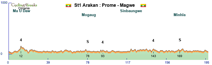
The tour starts in Prome (also known as Pyay), a burmese town with a long history. Next to the current town was the capital of the famous Pyu kingdom between the XVII and XI century.
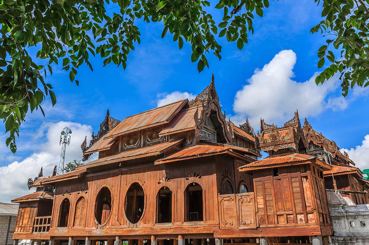
The stage goes up North to finish in Magwe where you can find impressive golden temples and sesame fields all around the town !
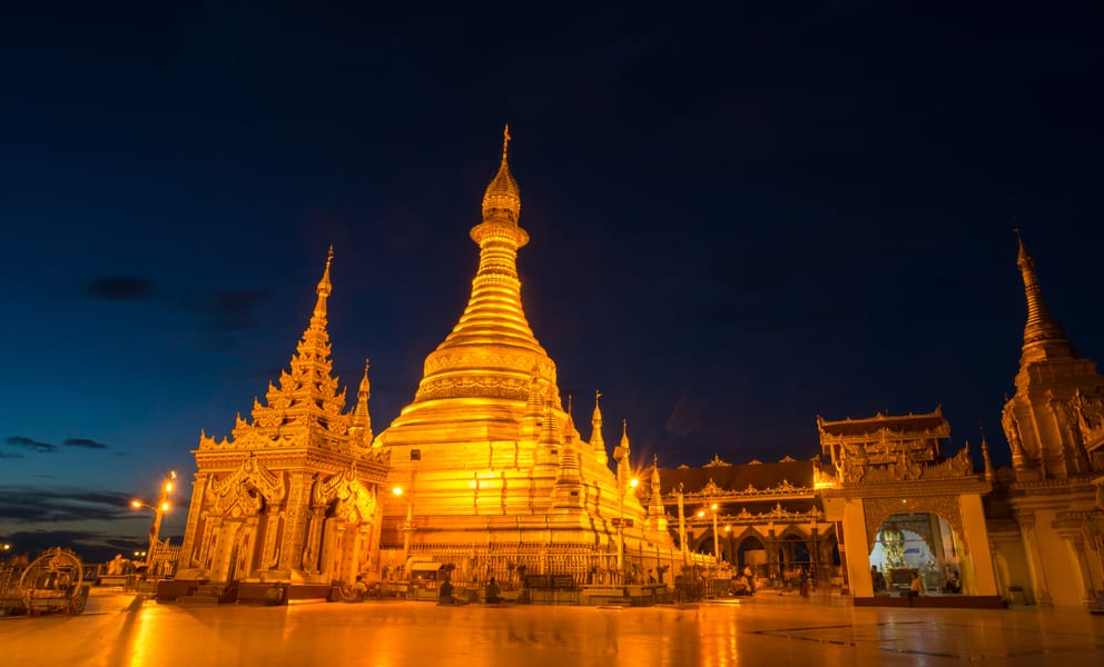
Stage 2
The second stage is also a flat stage, but shorter than the first one and with a couple of hills mid-race. That could make it difficult for some pure sprinters, especially if not well surrounded by strong helpers.
Kom3cat : 4/2/6/9/1/4/5
Kom4cat : 6/6
No sieb after these.
Mintakt km 143
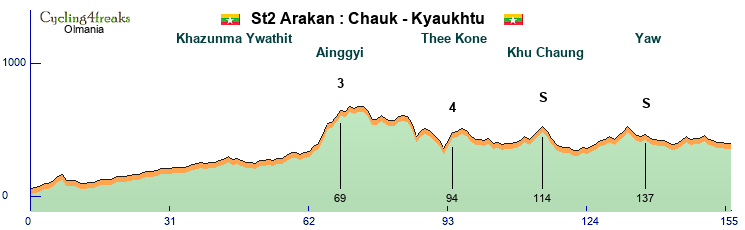
Not far from Magwe, the second stage starts in Chauk. That small town is known to be sitting on oil !
The finish line is in Kyaukhtu near a huge airport (compared to the size of the town !).
Stage 3
The third stage is again an opportunity for a sprinter. 3 stages for sprinters to shine to start that tour, a fight for stages, green and temporary yellow ! This stage is the longest of the Arakan tour. The first part is slightly hilly with two categorized climbs, and then it’s quite easy and sprinter teams should be able to control that long stage for a mass sprint.
Kom4cat : 11%
Mintakt km213
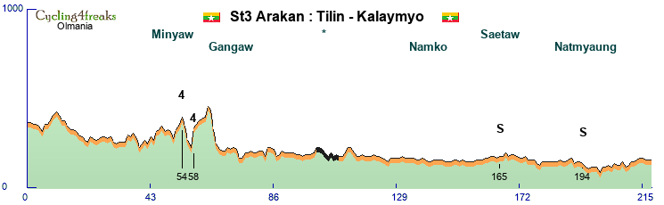
Tilin is a small town, where you can apparently find amber nearby and this provides info about what was the fauna there during mesozoic times !
Kalaymyo (also known as Kale) is a fast growing city and was a key city in the protests of 2007, asking for the release of Aung San Suu Kyi (nobel price).
Stage 4
The first stage with a real climb comes now ! The stage is easy to divide in 3 parts : flat / big hill / flat.
Pure sprinters have no chance except if no team decides to speed up the hills. Classic riders or hillsprinters are the favorites here. First big points for the mountain jersey here !
Kom2cat : 12kms @ 4,6% (with sieb)
Kom1cat : 16kms @ 6,9% (with steep sieb and flatish parts)
Mintakt km167
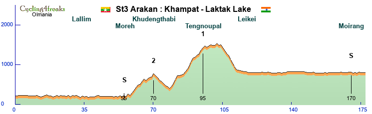
Still going North, the star city is Khampat, not far from Kalaymyo. It’s near the indian border that the stage starts and after a few kms and a left turn, the race enters India. The finish line is drawn on the shore of Loktak lake, heart of the Manipur state in India. That lake provides fresh water, and incredible views due to the semi artificial fisheries built and used on the lake :

Stage 5
The race is now heading west, crossing the Manipur mountains. It’s up and down all day, even if the stage is short. Not all climbs are steep; like the final climb which is irregular, but not steep average (final kms are : 7/0/7/4/3/5/2/3/3). Hard to guess who are the favorites and the scenario here. That’s also an important day for the mountain jersey fight !
Kom2cat : 7kms @7%
Kom2cat : 9kms @8,2%
Kom3cat : 6kms @6,5%
Kom3cat : 12kms @3,7% (and after that the final kms listed in details up here in the text)
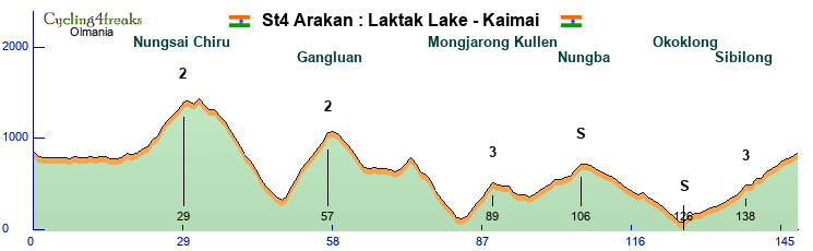
The stage starts from Loktak lake where the race arrived the day before.
Kamai is a small village pass in the mountains, where there is … a new train station ! But also, waterfalls nearby if some riders needs to cool down after the race.
Stage 6
An ITT for pure specialists. 50Kms of flat, with only a 4% to force riders to change gears at least once ! Of course big gaps will be created here, and will hopefully open the race for the following days. Also, that ITT is long, so recovery for leaders will be important, but maybe even more important for helpers knowing what stage comes next.
Mintakt km1
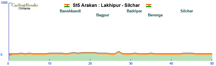
Down in the valley, not far from Kamai, the ITT starts in Lhakipur. That town is known to be really wet, with heavy downpour during the monsoon because of its location, surrounded by mountains blocking the clouds. Hopefully for the riders, it will be the dry and cool season ! 50Kms later, the finish line is in Silchar, the second largest city of Assam state. Silchar is often flooded when it rains too much near Lhakipur !
Stage 7
Some leaders might be exhausted after the ITT and there’s no rest for them in that last stage before … rest day ! The first part of the stage is full of traps, and that includes the steepest wall of the whole tour and a gravel road. At the end of the stage, there’s a long climb and downhill to cross the border at the bottom and arrive in … Bengladesh !
Kom2cat : 2kms @ 15%
Kom1cat : 23kms @ 4,4% with many siebs kms
Gravel sections, first 3kms are *, and then **
Mintakt km125
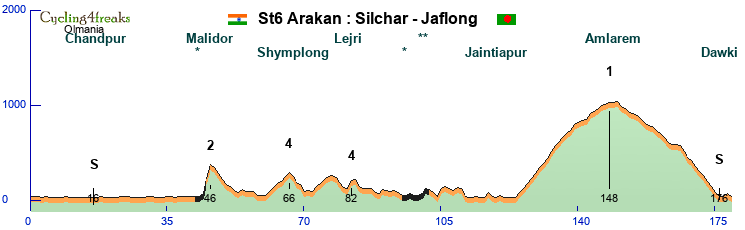
After Silchar, riders will follow a valley with many waterfalls (see pictures after). The finish line is in the only city from Bengladesh hosting a stage of the Arakan tour : Jaflong. Well known to be a touristic destination, riders will be looking forward to enjoy their day off there after crossing the finish line ! Or will they transfer to Dimapur straight after the 7th stage to have their rest day in India ?
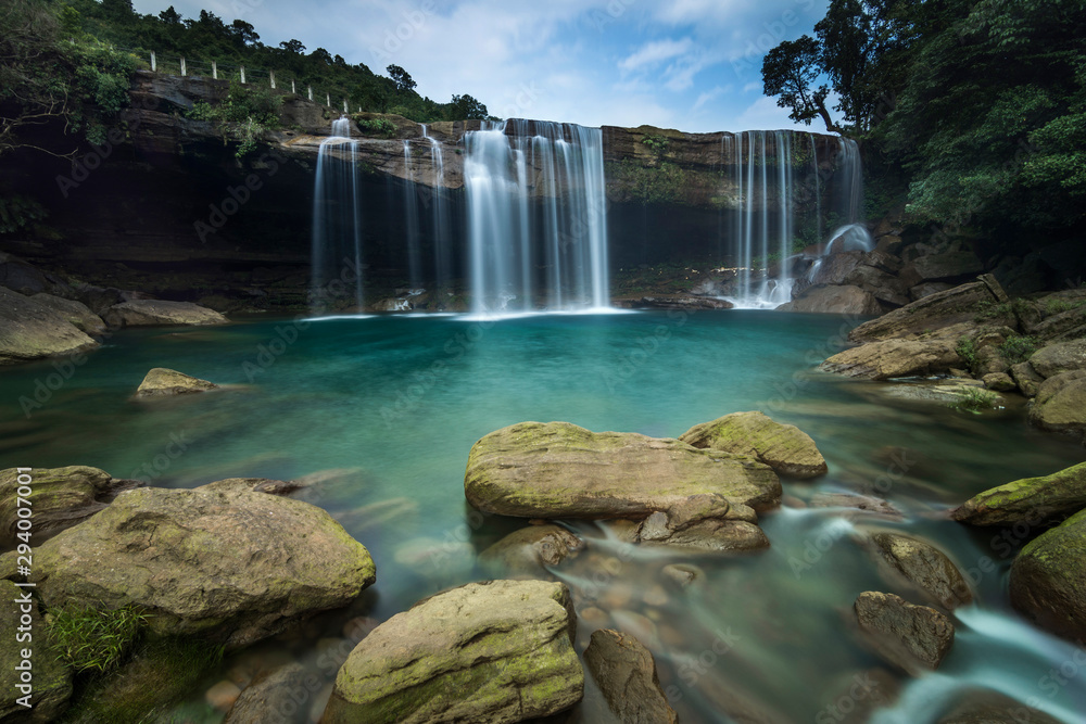
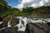
Yes, theses pictures are heavily photoshopped but the waterfall are still nice looking even if you just see them from the bike !
REST DAY
Jaflong or Dimapur for the day off ? Rider’s and team’s choice :

Chill and recovery in a lovely environment in quiet Jaflong ?
Or active recovery while being a cultural nerd tourist in buzzing Dimapur ?
Stage 8
Sprinter teams are back in the game after the rest day ! 2 short categorized climbs early in the stage, and an easy gravel road (*) won’t scare the fresh teams who want a mass sprint.
Sieb are only possible in the Kom4cat, and then it’s 4% max.
Last 3kms are 0/2/1
Mintakt km158
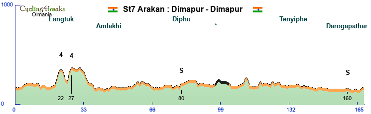
Start and arrival in Dimapur, where you can visit the Ruins of Kachari Rajbari, a series of medieval mushrooms domed pillars (see picture before), their purpose still remain a mystery !
Dimapur is also the largest city and the capital of Nagaland state where teams will find good hotels and plenty of supplies before the coming days.
Stage 9
The stage starts again in Dimapur but takes another direction : east to the mountains ! The first climb is long, irregular, with many opportunities for early sieb but also flatish sections in order to reach Kohima, a city built on a long crest; where a famous battle of WW2 happened.
Then it’s down and up with no break. Offensive teams could try something. Climbers need to gain back lots of time on TT riders here. That stage will also be important for the ones targeting the climbing jersey. 9th stage is quite long and will surely exhaust a big part of the peloton !
Kom3cat : 9kms @ 4,2% (with sieb, and only the last part before the kom; the whole climb is a lot longer)
Kom1cat : 21kms @ 4,7% (hard sieb and flatish parts)
Kom2cat : 8kms @ 5% (with sieb kms)
Kom1cat : 18kms @ 5,1% (irregular, max 11%)
Mintakt km168
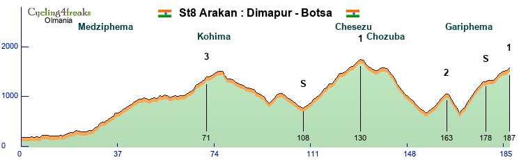
Botsa where the hilltop finish occurs is a typical village of the Naga people : lying on a mountain crest, with cultivated terraces, a couple of churches, shops and hotels along the mountain road passing by.
During the whole stage, the rides will be under the look and supervision of one of the highest peak of the Arakan mountains, Japfu Peak, near Kohima :

Stage 10
There is more downhill than uphill in that 10th stage. It could be an “easy” one where the breakaway gets away ! Or a crazy one where some teams try to gain time (again) against the tired legs of the days before. That actually also could be a day for sprinters ! In fact, in case no one speeds up too fast in the climbs, the last part of the stage is quite easy with mostly downhill and flat sections.
Last siebs are possible km135 (7%), km162 (6%) and eventually later for some riders on a couple of 5%.
Kom3cat : 7kms @ 4,7% (with sieb)
Kom2cat : 13kms @ 4,9% (with sieb, max 11%)
Mintakt km178
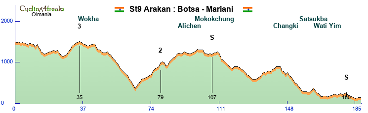
After a good night in the hotels along the road in Botsa, the riders will cross Mokokchung an impressive town built on the hill top of the mountain (see picture after) and go down back in the valley. The finish line will be in Mariani a small rural town with hopefully no link with Jacques or Thierry !
A view of Mokokchung where riders can compete for an intermediate sprint :
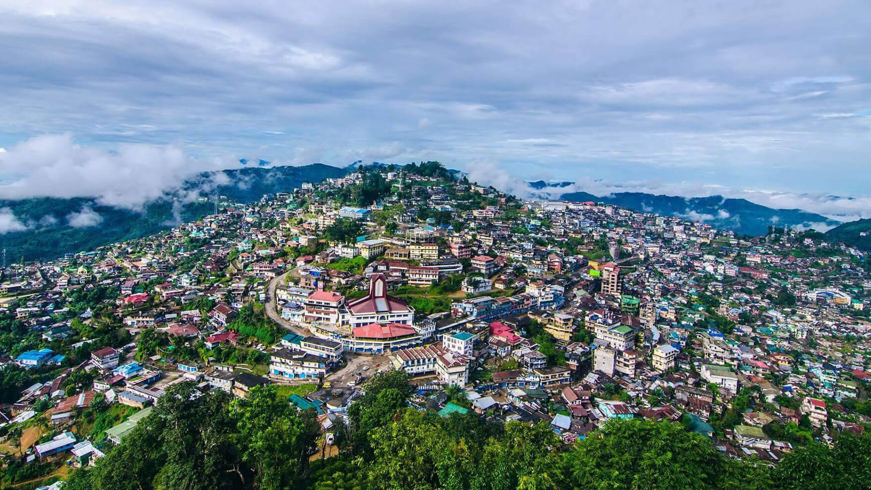
Stage 11
Last chance for sprinters to shine in this Arakan tour ! This flat stage along the Bhramaputra valley has two climbs that could create a bit of chaos within the sprinters teams. But these climbs are not really steep and there is over 60kms of flat after the last climb. Breakaway specialists that can not climb very well will probably also target that stage as they won't have a chance in the breakaways of the two finals stages !
Kom2cat : 11kms @ 4,6% (max 6%)
Kom3cat : 13kms @ 3,7% (max 5%)
Mintakt km176
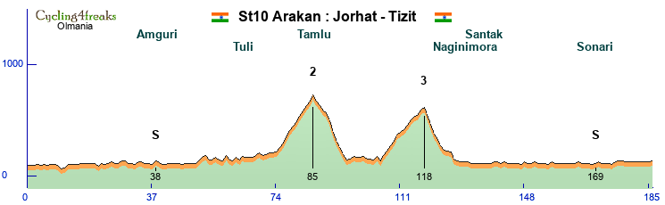
Now in Assam state, the stage starts in Jorhat a cosmopolite town in the Bhramaputra valley. Near Jorhat is the single handedly planted Mosai forest on 550 hectares along the Bhramaputra. Jadav ‘Molai’ Payeng a forestry worker and environmental activist became a national figure for planting that forest alone during 30 years. It is fastly growing and host now an incredible flora and fauna (including a 100 elephants herd !) and became a natural reserve. You can learn more about him and the forest in a documentary that was shown at Cannes film festival called “forest man”.
The stage finishes in Tizit, a small village known for its spice market !
Jadav ‘Molai’ Payeng in the forest reseve now named after him :

Stage 12
The last mountain stage of the Arakan tour now ! It starts with a long and irregular climb straight from the start. Then it’s ondulating for a while, with possible sieb, especially in the cat3. And it finishes by a long and difficult climb and a shorter downhill where climbers will create important gaps for sure. The stage is short; offering the opportunity for teams to start the fight early on. But it’s not the last stage of the Arakan tour, and that's an important detail to keep in mind !
Kom2cat : 4 uphill sections with possible sieb, but with flatish sections inbetween :
4kms @ 5,5%
6kms @ 6,2%
1km @ 11%
4kms @ 5,8%
Kom3cat : 5kms @ 7,4%
Kom1cat : 19kms @ 5,4% (max 9%)
Last 5kms : 0/-7/-3/-2/-2
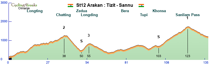
After starting in Tizit, the roads goes deep in the mountains and in the forest of Arunachal Pradesh, near the Burmese border. Even in the dry season, the mountain roads could be stuck in fog and wet, be careful in the last downhill to Sonna, a small forest village. The finish line is special because it is drawn … a bridge :
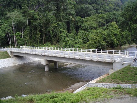
Stage 13
Last stage of the Arakan, finally ! It’s hilly, and could lead to many (final) surprises. Many siebs are possible early on the stage, but the final circuit is the key. It includes a long gravel section (10kms of * followed by 10kms of **) that everyone will talk about even before the race starts on day1. That gravel sections has siebs in it (with a 8% climb as the steepest one). Pure chaos on that short final stage ? Possible. Fight for the stage (and maybe green jersey ?) in front, while fight for GC positions in the back ? Highly possible !
We expect to see tired faces, covered of dust (or mud) at the end of the Arakan final stage.
Kom4cat : 4kms @ 4% (max 7%)
Kom3cat : 6kms @ 5,5 (max8%)
possible sieb on uncategorized climbs, including in the final circuit on road and on gravel (different sections from 6% to 8%).
Mintakt km123
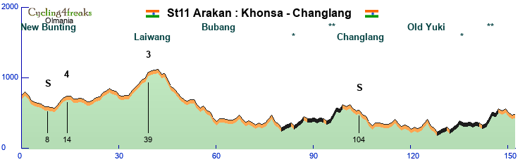
The final stage starts on the other side of the Sanliam pass, the final climb the riders climbed the day before. Khonsa is the main village of these wild and isolated Arunachal Pradesh mountains. The finsh of the Arakan tour is in Changlang, one of the main towns of the area. Changlang has oil, coal and other mineral ressources in its soil. And that’s on one of the gravel roads going to different mineral exploitation sites that the peloton will ride in the two final laps.
A view of Changland where the Arakan tour ends :
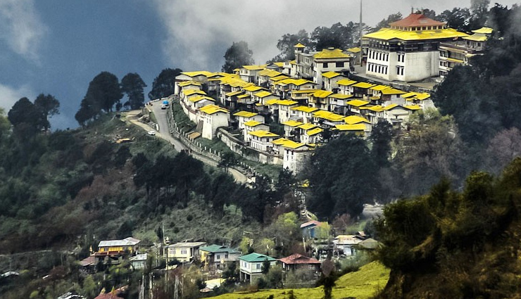
The Arakans Mountains are located in western Myanmar and continues up to the north in India, including many parallel mountain ridges like the Patkai Ridge and also Naga Hills, Chin Hills, etc.
The Arakan tour follows the mountains, from the South to the North. Starting in Myanmar and ending in India with a short stop in Bengladesh mid-way.
The stages undulates along and near the Arakan mountains but are not only in the mountains of course !
These mountains offer different kind of landscapes and climates according the to side (east/west) and the altitude.
At this time of the year riders can expect cool to warm temperatures, maybe a couple of hot days and a couple of fresh downhills in the mountains. Nothing extreme, and mostly dry and it’s the “dry” season and not the monsoon time. So, even the steep downhills and the short gravel sections should be safe to ride. December is probably the best time of the year for a bike race there !
[Recap map will be added here soon]
The route crosses borders and areas where it is not possible to do so at the moment because of multiple local issues. Even if there are many problems there about human rights, fights and so on, that tour is fantasy and allows the peloton to go everywhere, in peace, hoping that could become true soon, meaning everything is better there.
The tour is mainly in India, but starts in Myanmar for a few days and makes a short stop in Bengladesh before the rest day.
The idea of that tour, is to offer opportunities for various teams and leaders to enjoy it. It is not an extreme tour at all, even if some stages are difficult. This tour could be for climbers, but it’s not a given tour to them. Climbers with ambitions in the GC will require strong support and probably offensive strategies ! Leaders with TT abilities could be GC favorites too, but they will also need strong support and recovery skills to have a chance. Sprinters can get a few stages and wear the leader’s jersey for a couple of days, but if they want the green jersey too, their teams will have to work a little extra on stages with a bit of denivelation. Classic riders will of course have their word for a few stages but their importance as key/luxury helpers for their leaders (GC contenders, but also sprinters) will be more important than in most tours.
But that’s only theory anyway, the race will be made by the managers and their line-ups at the end
Tour recap :
Stages classification :
Flat : 5
Hilly : 4
Mountain : 3
ITT : 1
13 Stages, 2143kms & 27570 of D+. 1 rest day.
2 IS per stage, with one often near the end.
Stage 1
The first stage is an easy one for sprinters. The only possible sieb (7%) is in the first KOM.
4kms before the finish line lies a +3%, and then it’s 3kms @ -1% to the line.
Mintakt km187.
The tour starts in Prome (also known as Pyay), a burmese town with a long history. Next to the current town was the capital of the famous Pyu kingdom between the XVII and XI century.
The stage goes up North to finish in Magwe where you can find impressive golden temples and sesame fields all around the town !
Stage 2
The second stage is also a flat stage, but shorter than the first one and with a couple of hills mid-race. That could make it difficult for some pure sprinters, especially if not well surrounded by strong helpers.
Kom3cat : 4/2/6/9/1/4/5
Kom4cat : 6/6
No sieb after these.
Mintakt km 143
Not far from Magwe, the second stage starts in Chauk. That small town is known to be sitting on oil !
The finish line is in Kyaukhtu near a huge airport (compared to the size of the town !).
Stage 3
The third stage is again an opportunity for a sprinter. 3 stages for sprinters to shine to start that tour, a fight for stages, green and temporary yellow ! This stage is the longest of the Arakan tour. The first part is slightly hilly with two categorized climbs, and then it’s quite easy and sprinter teams should be able to control that long stage for a mass sprint.
Kom4cat : 11%
Mintakt km213
Tilin is a small town, where you can apparently find amber nearby and this provides info about what was the fauna there during mesozoic times !
Kalaymyo (also known as Kale) is a fast growing city and was a key city in the protests of 2007, asking for the release of Aung San Suu Kyi (nobel price).
Stage 4
The first stage with a real climb comes now ! The stage is easy to divide in 3 parts : flat / big hill / flat.
Pure sprinters have no chance except if no team decides to speed up the hills. Classic riders or hillsprinters are the favorites here. First big points for the mountain jersey here !
Kom2cat : 12kms @ 4,6% (with sieb)
Kom1cat : 16kms @ 6,9% (with steep sieb and flatish parts)
Mintakt km167
Still going North, the star city is Khampat, not far from Kalaymyo. It’s near the indian border that the stage starts and after a few kms and a left turn, the race enters India. The finish line is drawn on the shore of Loktak lake, heart of the Manipur state in India. That lake provides fresh water, and incredible views due to the semi artificial fisheries built and used on the lake :
Stage 5
The race is now heading west, crossing the Manipur mountains. It’s up and down all day, even if the stage is short. Not all climbs are steep; like the final climb which is irregular, but not steep average (final kms are : 7/0/7/4/3/5/2/3/3). Hard to guess who are the favorites and the scenario here. That’s also an important day for the mountain jersey fight !
Kom2cat : 7kms @7%
Kom2cat : 9kms @8,2%
Kom3cat : 6kms @6,5%
Kom3cat : 12kms @3,7% (and after that the final kms listed in details up here in the text)
The stage starts from Loktak lake where the race arrived the day before.
Kamai is a small village pass in the mountains, where there is … a new train station ! But also, waterfalls nearby if some riders needs to cool down after the race.
Stage 6
An ITT for pure specialists. 50Kms of flat, with only a 4% to force riders to change gears at least once ! Of course big gaps will be created here, and will hopefully open the race for the following days. Also, that ITT is long, so recovery for leaders will be important, but maybe even more important for helpers knowing what stage comes next.
Mintakt km1
Down in the valley, not far from Kamai, the ITT starts in Lhakipur. That town is known to be really wet, with heavy downpour during the monsoon because of its location, surrounded by mountains blocking the clouds. Hopefully for the riders, it will be the dry and cool season ! 50Kms later, the finish line is in Silchar, the second largest city of Assam state. Silchar is often flooded when it rains too much near Lhakipur !
Stage 7
Some leaders might be exhausted after the ITT and there’s no rest for them in that last stage before … rest day ! The first part of the stage is full of traps, and that includes the steepest wall of the whole tour and a gravel road. At the end of the stage, there’s a long climb and downhill to cross the border at the bottom and arrive in … Bengladesh !
Kom2cat : 2kms @ 15%
Kom1cat : 23kms @ 4,4% with many siebs kms
Gravel sections, first 3kms are *, and then **
Mintakt km125
After Silchar, riders will follow a valley with many waterfalls (see pictures after). The finish line is in the only city from Bengladesh hosting a stage of the Arakan tour : Jaflong. Well known to be a touristic destination, riders will be looking forward to enjoy their day off there after crossing the finish line ! Or will they transfer to Dimapur straight after the 7th stage to have their rest day in India ?
Yes, theses pictures are heavily photoshopped but the waterfall are still nice looking even if you just see them from the bike !
REST DAY
Jaflong or Dimapur for the day off ? Rider’s and team’s choice :
Chill and recovery in a lovely environment in quiet Jaflong ?
Or active recovery while being a cultural nerd tourist in buzzing Dimapur ?
Stage 8
Sprinter teams are back in the game after the rest day ! 2 short categorized climbs early in the stage, and an easy gravel road (*) won’t scare the fresh teams who want a mass sprint.
Sieb are only possible in the Kom4cat, and then it’s 4% max.
Last 3kms are 0/2/1
Mintakt km158
Start and arrival in Dimapur, where you can visit the Ruins of Kachari Rajbari, a series of medieval mushrooms domed pillars (see picture before), their purpose still remain a mystery !
Dimapur is also the largest city and the capital of Nagaland state where teams will find good hotels and plenty of supplies before the coming days.
Stage 9
The stage starts again in Dimapur but takes another direction : east to the mountains ! The first climb is long, irregular, with many opportunities for early sieb but also flatish sections in order to reach Kohima, a city built on a long crest; where a famous battle of WW2 happened.
Then it’s down and up with no break. Offensive teams could try something. Climbers need to gain back lots of time on TT riders here. That stage will also be important for the ones targeting the climbing jersey. 9th stage is quite long and will surely exhaust a big part of the peloton !
Kom3cat : 9kms @ 4,2% (with sieb, and only the last part before the kom; the whole climb is a lot longer)
Kom1cat : 21kms @ 4,7% (hard sieb and flatish parts)
Kom2cat : 8kms @ 5% (with sieb kms)
Kom1cat : 18kms @ 5,1% (irregular, max 11%)
Mintakt km168
Botsa where the hilltop finish occurs is a typical village of the Naga people : lying on a mountain crest, with cultivated terraces, a couple of churches, shops and hotels along the mountain road passing by.
During the whole stage, the rides will be under the look and supervision of one of the highest peak of the Arakan mountains, Japfu Peak, near Kohima :
Stage 10
There is more downhill than uphill in that 10th stage. It could be an “easy” one where the breakaway gets away ! Or a crazy one where some teams try to gain time (again) against the tired legs of the days before. That actually also could be a day for sprinters ! In fact, in case no one speeds up too fast in the climbs, the last part of the stage is quite easy with mostly downhill and flat sections.
Last siebs are possible km135 (7%), km162 (6%) and eventually later for some riders on a couple of 5%.
Kom3cat : 7kms @ 4,7% (with sieb)
Kom2cat : 13kms @ 4,9% (with sieb, max 11%)
Mintakt km178
After a good night in the hotels along the road in Botsa, the riders will cross Mokokchung an impressive town built on the hill top of the mountain (see picture after) and go down back in the valley. The finish line will be in Mariani a small rural town with hopefully no link with Jacques or Thierry !
A view of Mokokchung where riders can compete for an intermediate sprint :
Stage 11
Last chance for sprinters to shine in this Arakan tour ! This flat stage along the Bhramaputra valley has two climbs that could create a bit of chaos within the sprinters teams. But these climbs are not really steep and there is over 60kms of flat after the last climb. Breakaway specialists that can not climb very well will probably also target that stage as they won't have a chance in the breakaways of the two finals stages !
Kom2cat : 11kms @ 4,6% (max 6%)
Kom3cat : 13kms @ 3,7% (max 5%)
Mintakt km176
Now in Assam state, the stage starts in Jorhat a cosmopolite town in the Bhramaputra valley. Near Jorhat is the single handedly planted Mosai forest on 550 hectares along the Bhramaputra. Jadav ‘Molai’ Payeng a forestry worker and environmental activist became a national figure for planting that forest alone during 30 years. It is fastly growing and host now an incredible flora and fauna (including a 100 elephants herd !) and became a natural reserve. You can learn more about him and the forest in a documentary that was shown at Cannes film festival called “forest man”.
The stage finishes in Tizit, a small village known for its spice market !
Jadav ‘Molai’ Payeng in the forest reseve now named after him :
Stage 12
The last mountain stage of the Arakan tour now ! It starts with a long and irregular climb straight from the start. Then it’s ondulating for a while, with possible sieb, especially in the cat3. And it finishes by a long and difficult climb and a shorter downhill where climbers will create important gaps for sure. The stage is short; offering the opportunity for teams to start the fight early on. But it’s not the last stage of the Arakan tour, and that's an important detail to keep in mind !
Kom2cat : 4 uphill sections with possible sieb, but with flatish sections inbetween :
4kms @ 5,5%
6kms @ 6,2%
1km @ 11%
4kms @ 5,8%
Kom3cat : 5kms @ 7,4%
Kom1cat : 19kms @ 5,4% (max 9%)
Last 5kms : 0/-7/-3/-2/-2
After starting in Tizit, the roads goes deep in the mountains and in the forest of Arunachal Pradesh, near the Burmese border. Even in the dry season, the mountain roads could be stuck in fog and wet, be careful in the last downhill to Sonna, a small forest village. The finish line is special because it is drawn … a bridge :
Stage 13
Last stage of the Arakan, finally ! It’s hilly, and could lead to many (final) surprises. Many siebs are possible early on the stage, but the final circuit is the key. It includes a long gravel section (10kms of * followed by 10kms of **) that everyone will talk about even before the race starts on day1. That gravel sections has siebs in it (with a 8% climb as the steepest one). Pure chaos on that short final stage ? Possible. Fight for the stage (and maybe green jersey ?) in front, while fight for GC positions in the back ? Highly possible !
We expect to see tired faces, covered of dust (or mud) at the end of the Arakan final stage.
Kom4cat : 4kms @ 4% (max 7%)
Kom3cat : 6kms @ 5,5 (max8%)
possible sieb on uncategorized climbs, including in the final circuit on road and on gravel (different sections from 6% to 8%).
Mintakt km123
The final stage starts on the other side of the Sanliam pass, the final climb the riders climbed the day before. Khonsa is the main village of these wild and isolated Arunachal Pradesh mountains. The finsh of the Arakan tour is in Changlang, one of the main towns of the area. Changlang has oil, coal and other mineral ressources in its soil. And that’s on one of the gravel roads going to different mineral exploitation sites that the peloton will ride in the two final laps.
A view of Changland where the Arakan tour ends :
Re: December Tour 2023 - Presentation
C4F Convention 2023
17 Years this game exist and win fans arround the world. It time to celebrate the Big present and past team in a Big Convention in San Diego. Welcome to the Cyclings for Freaks Convention in San Diego.
We needs time for our Fans who came to this Convention, so we make shorter Stages to have enough time for meet and greets and lots of signatures.
We Stay the whole tour in Sand Diego. The rider stay in the same Hotel the same Tour, the logistics have short ways.
8 Rider/Team
10 Stages
4 Flat
1 Hilly
4 Mountain
1 TTT
First Stage Hilly 128 km, mintact km 116
In honour of Radler, aka Buhmann. The guy who start todo this game and make in works. Without him, nobody would play this game.
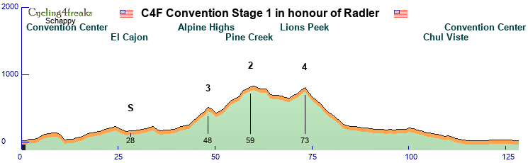
Three little Hills to show the hard way to make this Game and in the End it is flat until Radler leave this Game.
Second Stage Mountain 139 km, mintact km 132
In honour of Zauverlehrlinge, a guy who improved the style to build teams in my eyes. A really nice guy who helps so much guys to understand this game.
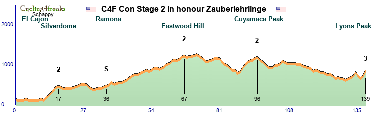
It is mostly a hilly stage with a steep last km.
This stage is for Pius Spycher. A rider who dominate 2007 this game. It was genius to ride with this guy.
Third Stage TTT 33 km
In honour of la bella italia who won the first TTT in C4F at the Giro 2006.
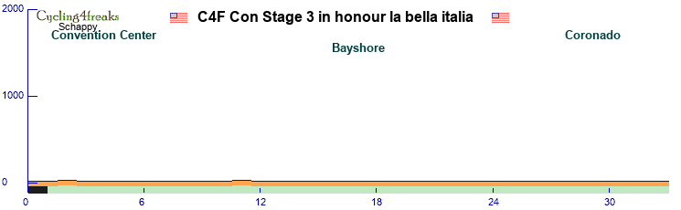
Full Flat TTT.
4. Stage Mountain 118 km, mintact km 104
In honour of Cerro Torre RT
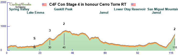
Two little early Hills and a big Mountain at the End. In memory of Andrus Veerpalu who wins the first Vuelta and was second at the first Giro in C4F.
5. Stage Flat 173 km, mintact km
In honour of iBanesto, the first super Sprinter Team.
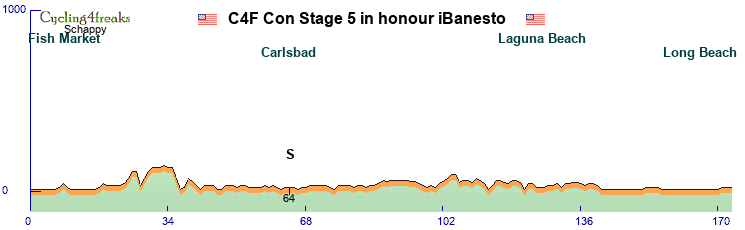
A Flat race to Long Beach L.A. to make a big meet and greet with fans and surfing a little bit. In memory of Stefan Schneller. He got 43 Sprint wins and at his retirement at 35 year he had still 95 sprintskill.
6. Stage Mountain 155 km, mintact km 128
In honour of lesossies the Grandfather of the game and the guy who keeps this game Alive until Luques take his part. And becaus, he is the father of the games father.
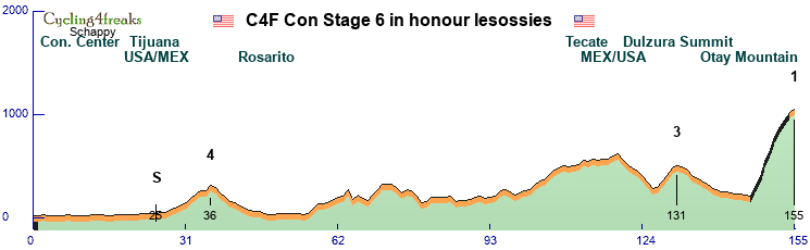
We visit Mexico in this stage to visit this guy who was an italian guy in C4F and had a restaurant in Mexico and end uphill with gravel roads at the Otay Mountain.
7. Stage Flat 124 km, mintact km 98
In honour of Alkworld for the improvement of the game and takeover to the ract version. He is one, who keeps this game still alive.
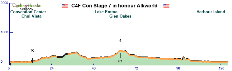
In this stage we road a little bit dirty roads and we have a short dirty hill 25 km before the finish line. So we get maybe a little fight for the stage betweend hill sprinter and Sprinter.
8. Stage Flat 160 km, mintact km 150
In honour of Gipfelstürmer who keeps this game with the other guys alive. Thanks a lot.
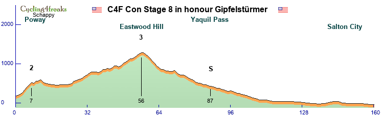
We ride a little bit out of San Diego and make a Barbecue at the Salton See in Salton City. We first ride two small hills and keep the road in the second half flat.
9. Stage Mountain 123 km, mintact km 102
In honour of Alive and Dead (name was to long in stage discription) who keeps this game with Alk and Gip alive. Helps a lot at my comeback. Thanks a lot.
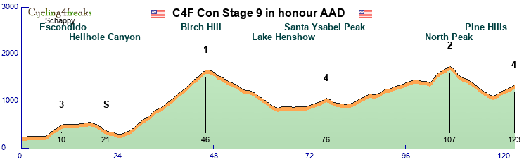
The queen stage of my December Tour. 3070 meter uphill in 123 km. A 20 km long Mountain, the Birch hill is in the middle of the stage. We end again uphill to the Pine Hills.
10. Stage Flat 109 km, mintact km 100
In honour of Big Donkey, Robyklebt, Petit Singe. The guy who make a long time the calendar in the game. He ride the most races here and make very much discuss things in the forum for a better game and often we hate him for some things. But without him, the game will not be the same.
We make a city tour through San Diego. We visit interesting places, the old Town, the Zoo, the San Diego bay, the diffenrent islands with some special zones.
We only have 10 Stages, because the rider want to be at the family until Christmas. So we dont honour all that i want to honour, but try to get the most impressed guys in my eyes. Luques of course is the one who get the 11. stage of course. We had very much guys, which we loved to ride with. Maybe in two Years for the next Convention.
17 Years this game exist and win fans arround the world. It time to celebrate the Big present and past team in a Big Convention in San Diego. Welcome to the Cyclings for Freaks Convention in San Diego.
We needs time for our Fans who came to this Convention, so we make shorter Stages to have enough time for meet and greets and lots of signatures.
We Stay the whole tour in Sand Diego. The rider stay in the same Hotel the same Tour, the logistics have short ways.
8 Rider/Team
10 Stages
4 Flat
1 Hilly
4 Mountain
1 TTT
First Stage Hilly 128 km, mintact km 116
In honour of Radler, aka Buhmann. The guy who start todo this game and make in works. Without him, nobody would play this game.
Three little Hills to show the hard way to make this Game and in the End it is flat until Radler leave this Game.
Second Stage Mountain 139 km, mintact km 132
In honour of Zauverlehrlinge, a guy who improved the style to build teams in my eyes. A really nice guy who helps so much guys to understand this game.
It is mostly a hilly stage with a steep last km.
This stage is for Pius Spycher. A rider who dominate 2007 this game. It was genius to ride with this guy.
Third Stage TTT 33 km
In honour of la bella italia who won the first TTT in C4F at the Giro 2006.
Full Flat TTT.
4. Stage Mountain 118 km, mintact km 104
In honour of Cerro Torre RT
Two little early Hills and a big Mountain at the End. In memory of Andrus Veerpalu who wins the first Vuelta and was second at the first Giro in C4F.
5. Stage Flat 173 km, mintact km
In honour of iBanesto, the first super Sprinter Team.
A Flat race to Long Beach L.A. to make a big meet and greet with fans and surfing a little bit. In memory of Stefan Schneller. He got 43 Sprint wins and at his retirement at 35 year he had still 95 sprintskill.
6. Stage Mountain 155 km, mintact km 128
In honour of lesossies the Grandfather of the game and the guy who keeps this game Alive until Luques take his part. And becaus, he is the father of the games father.
We visit Mexico in this stage to visit this guy who was an italian guy in C4F and had a restaurant in Mexico and end uphill with gravel roads at the Otay Mountain.
7. Stage Flat 124 km, mintact km 98
In honour of Alkworld for the improvement of the game and takeover to the ract version. He is one, who keeps this game still alive.
In this stage we road a little bit dirty roads and we have a short dirty hill 25 km before the finish line. So we get maybe a little fight for the stage betweend hill sprinter and Sprinter.
8. Stage Flat 160 km, mintact km 150
In honour of Gipfelstürmer who keeps this game with the other guys alive. Thanks a lot.
We ride a little bit out of San Diego and make a Barbecue at the Salton See in Salton City. We first ride two small hills and keep the road in the second half flat.
9. Stage Mountain 123 km, mintact km 102
In honour of Alive and Dead (name was to long in stage discription) who keeps this game with Alk and Gip alive. Helps a lot at my comeback. Thanks a lot.
The queen stage of my December Tour. 3070 meter uphill in 123 km. A 20 km long Mountain, the Birch hill is in the middle of the stage. We end again uphill to the Pine Hills.
10. Stage Flat 109 km, mintact km 100
In honour of Big Donkey, Robyklebt, Petit Singe. The guy who make a long time the calendar in the game. He ride the most races here and make very much discuss things in the forum for a better game and often we hate him for some things. But without him, the game will not be the same.
We make a city tour through San Diego. We visit interesting places, the old Town, the Zoo, the San Diego bay, the diffenrent islands with some special zones.
We only have 10 Stages, because the rider want to be at the family until Christmas. So we dont honour all that i want to honour, but try to get the most impressed guys in my eyes. Luques of course is the one who get the 11. stage of course. We had very much guys, which we loved to ride with. Maybe in two Years for the next Convention.
I´ve got the magic in me
Re: December Tour 2023 - Presentation
Hawaii Winter Race
Welcome the best place to be in December Hawaii. The organizers provide a short presentation of the 13-day tour (including 1 rest day). They want to apologize for using metrics units as most of the riders and managers are European and therefore not intelligent enough to work with a totally unlogical system. Feel free to convert all units to miles and feet.
Important: Look at this presentation to get much more information than just the profiles!
https://drive.google.com/file/d/1DS6dAY ... sp=sharing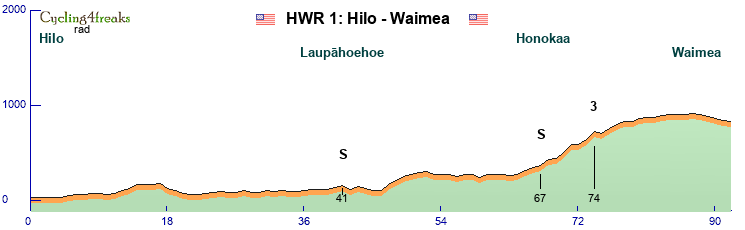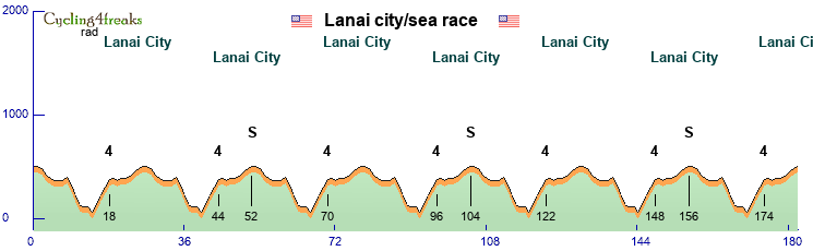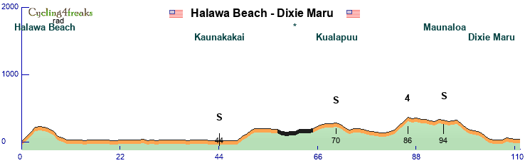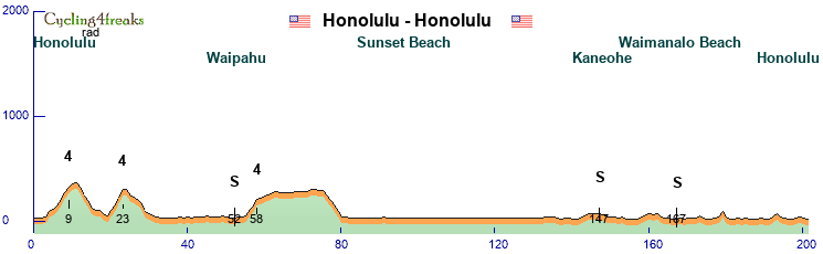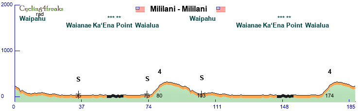
Re: December Tour 2023 - Presentation
South East Asian Tour
sponsored by SEAT


The South East Asian Tour (SEAT) will take place in South East Asia (surprise)
7 Countries (Singapur,Malaysia,Vietnam,Cambodia,Laos,Thailand,Myanmar)
14 Days, 14 Stages(1 day Halfstages), 1 Restday
9 riders per Team
5 Flat Stages
4 hilly stages
3 Mountain stages
1 ITT
1 TTT
Because profile links doesnt work anymore for Details on the stages you have to check the profiles in the editor ingame.
On every stage there will be 2 SEAT intermediate sprints
Map


Stage 1: Flat 197km 630Hm
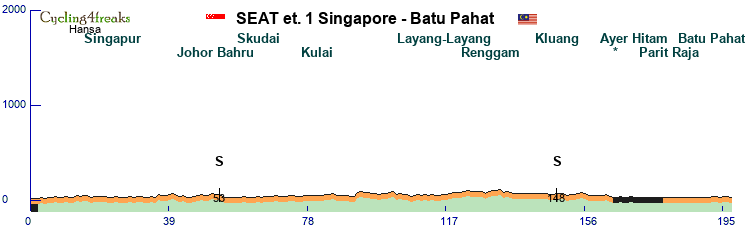
We start this Tour in Singapore

and finish Stage 1 in Batu Pahat

Stage 2: Flat 192km 1130Hm
We will start in Malacca
and finish our Race next to the Petronas tower in Kuala Lumpur.
Stage 3A: TTT 24km 20HM
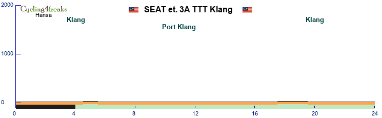
The TTT will be from Klang to Port Klang and back.

Stage 3B: Flat 120km 0HM
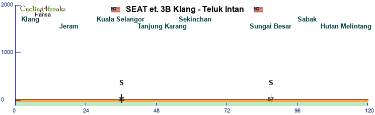
On Stage 3B we will go on the Coast from Klang to Teluk Intan
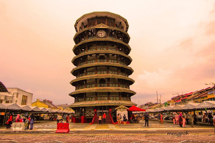
Stage 4: Mountain 193km 1,720Hm
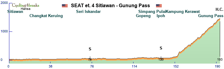
We wills tart stage 4 in Sitiawan
and go to the Gunung Pass

Stage 5: Flat 196km 940Hm
This stage is categorized as flat but with the hill kms before the finish there will be a chance for classics.
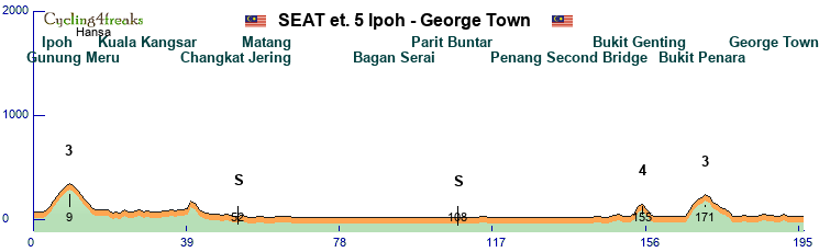
Here we start in Ipoh
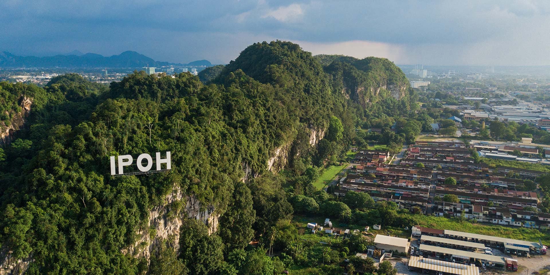
and will finish in George Town

____________________________________________________________________________________________________________________________
RESTDAY
We will transfer from Malaysia to Vietnam
____________________________________________________________________________________________________________________________
Stage 6: Hilly 204km 2,090Hm
After the Restday we start with a hilly stage in Vietnam.
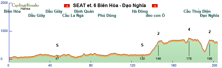
We will start in Bien Hoa

and finish in Dao Nghia

Stage 7: Hilly 182km 630Hm
Stage 7 with a bit hilly end on non paved road.
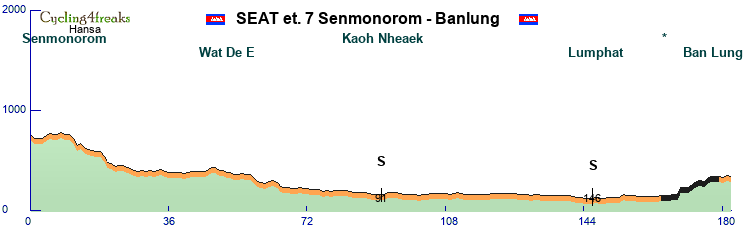
starting in Senmonorom
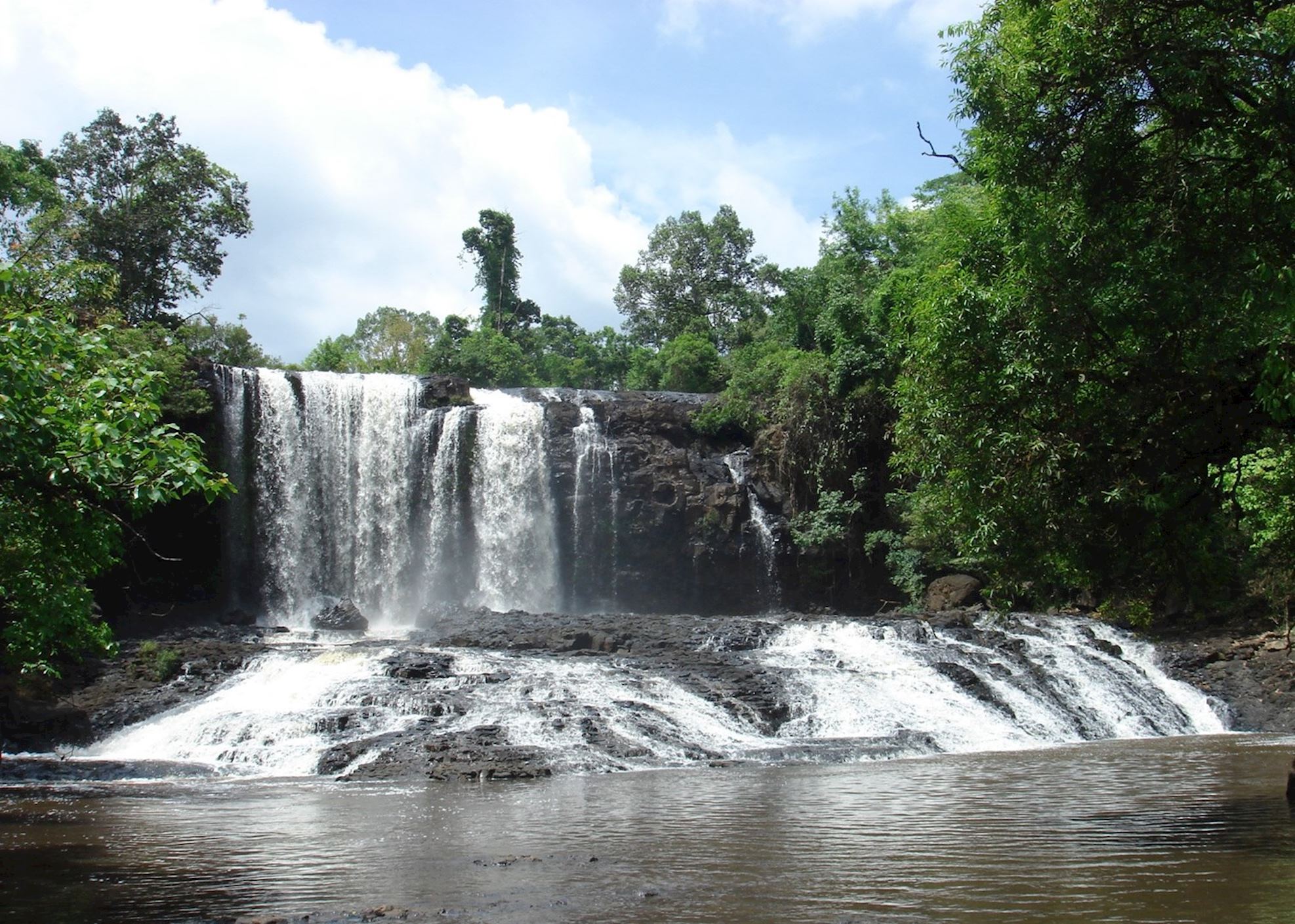
finishing in Ban Lung

Stage 8: Flat 202km 600Hm
Our last Flat stage of the Tour.
Starting in Pakse
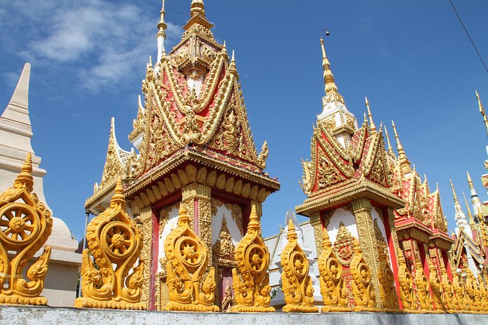
going to Ban Phosay
Stage 9: Hilly 200km 3,450Hm
With stage 9 we will start in the harder days of our tour.
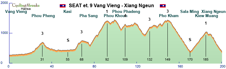
Here we will start in Vang Vieng
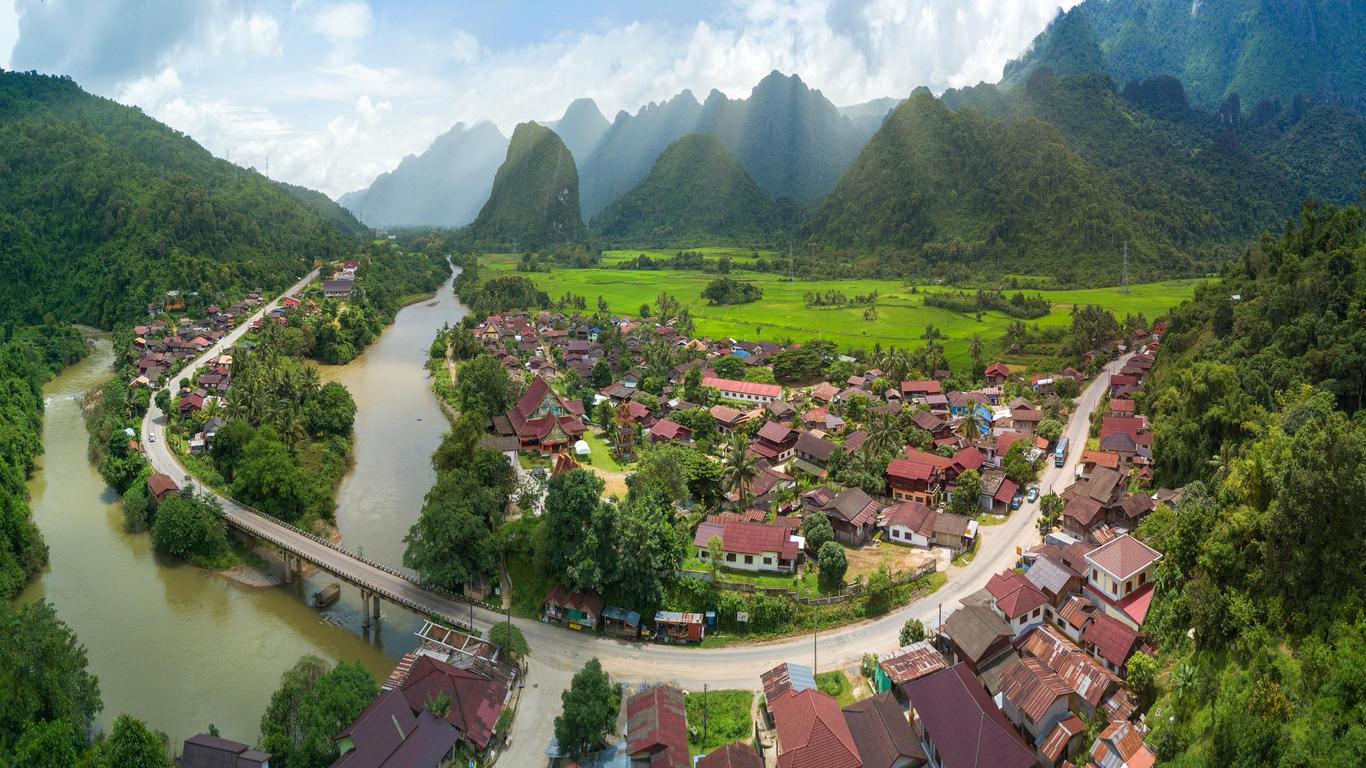
and will got over some mountains to Xiang Ngeun

Stage 10: Mountain 187km 3,260Hm
Here we will have our 2nd Mountain Top finish
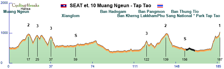
Starting in Muang Ngeun
we go the the National Park Tap Tao
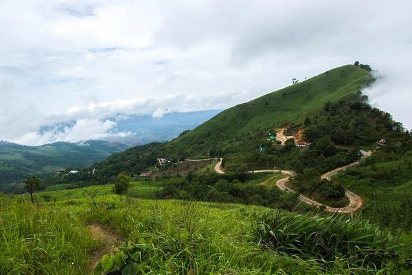
Stage 11: ITT 42km 1,390Hm
A hard and pretty long ITT, maybe the decisive stage of the Tour.
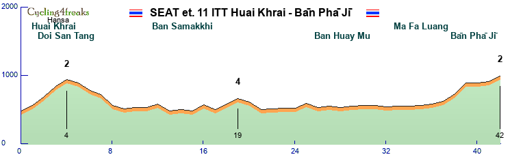
Here we will go from Huai Khrai

to Ban Pha Ji
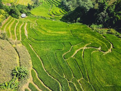
Stage 12: Mountain 188km 4,770Hm
after ITT we will have our Kings stage another mountain Top finish. Reg could play a huge role here.
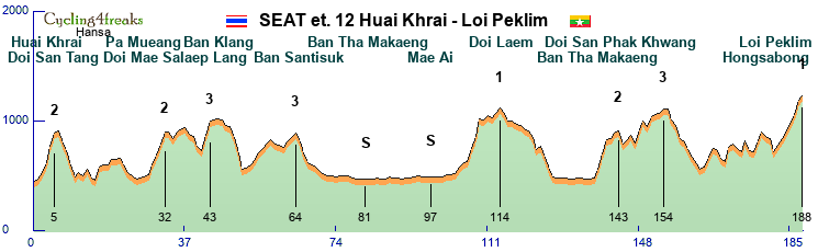
we will once again start in Huai Khrai and got to the Loi Peklim
on the route we will pass Mae Ai twice
Stage 13: Hilly 188km 4,010Hm
Last day, Last chance! And the profile makes it possible. An hard hilly stage with offroad parts.
Many thinks can happen here.
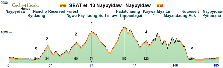
Going from Naypyidaw
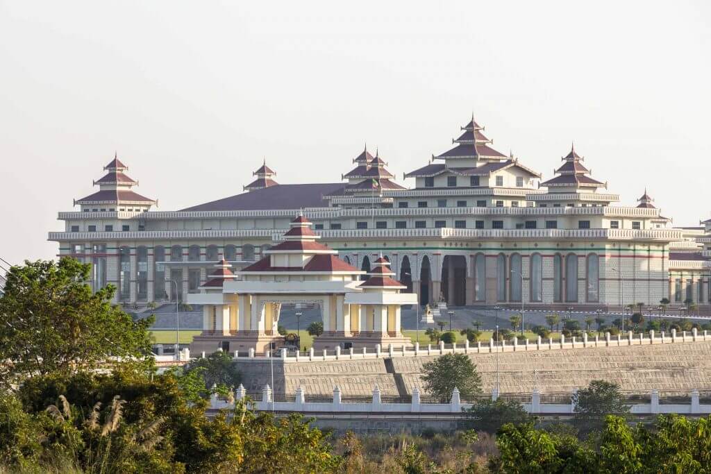
through the Mya Thida Tun Eco Resort
back to Naypyidaw to finish the tour next to the Uppatasanti Pagoda
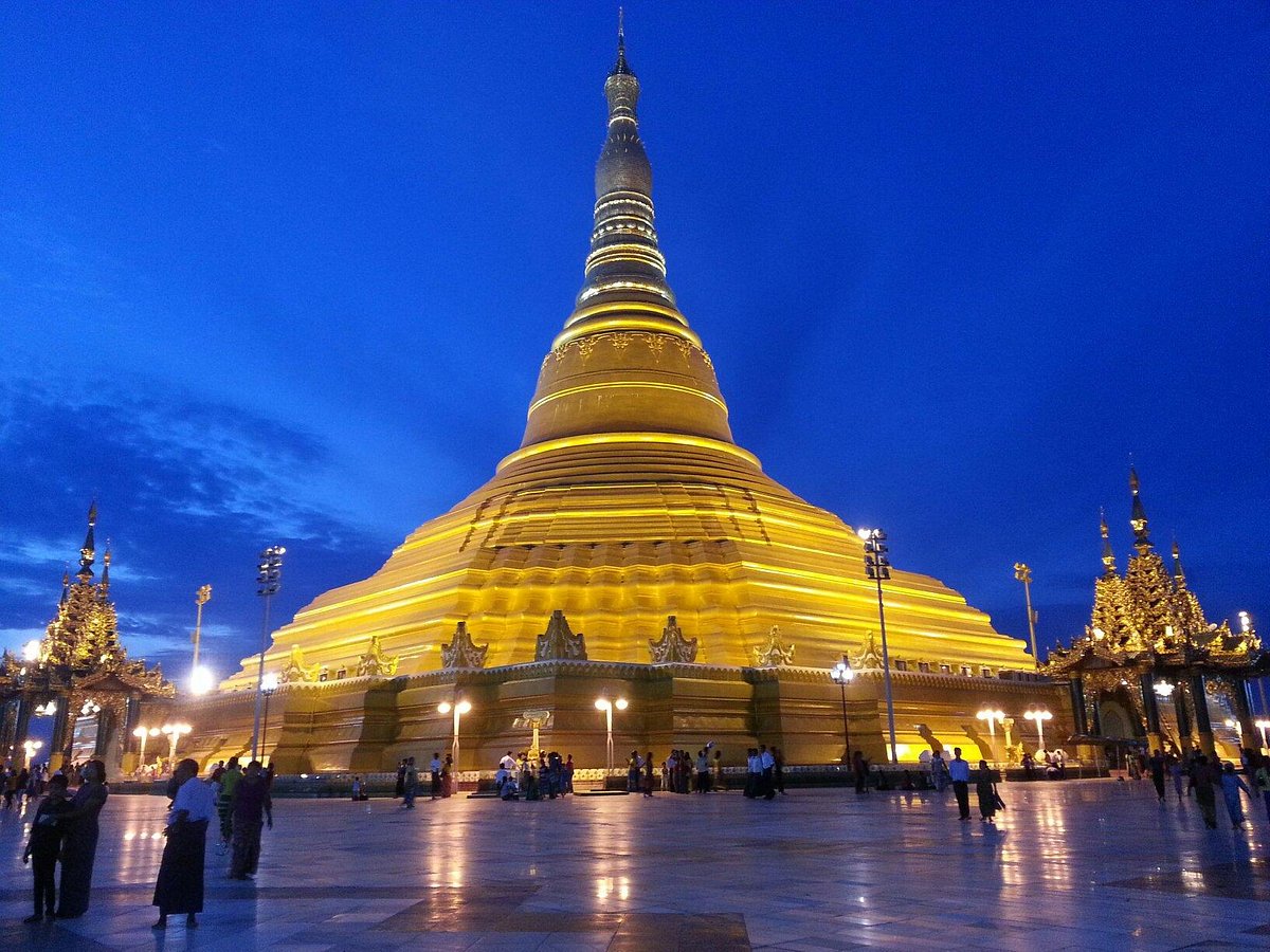
sponsored by SEAT
The South East Asian Tour (SEAT) will take place in South East Asia (surprise)
7 Countries (Singapur,Malaysia,Vietnam,Cambodia,Laos,Thailand,Myanmar)
14 Days, 14 Stages(1 day Halfstages), 1 Restday
9 riders per Team
5 Flat Stages
4 hilly stages
3 Mountain stages
1 ITT
1 TTT
Because profile links doesnt work anymore for Details on the stages you have to check the profiles in the editor ingame.
- Screenshot 2023-10-31 212417.png (43.42 KiB) Viewed 1097 times
Map
Stage 1: Flat 197km 630Hm
We start this Tour in Singapore
and finish Stage 1 in Batu Pahat
Stage 2: Flat 192km 1130Hm
We will start in Malacca
and finish our Race next to the Petronas tower in Kuala Lumpur.
Stage 3A: TTT 24km 20HM
The TTT will be from Klang to Port Klang and back.
Stage 3B: Flat 120km 0HM
On Stage 3B we will go on the Coast from Klang to Teluk Intan
Stage 4: Mountain 193km 1,720Hm
We wills tart stage 4 in Sitiawan
and go to the Gunung Pass
Stage 5: Flat 196km 940Hm
This stage is categorized as flat but with the hill kms before the finish there will be a chance for classics.
Here we start in Ipoh
and will finish in George Town
____________________________________________________________________________________________________________________________
RESTDAY
We will transfer from Malaysia to Vietnam
____________________________________________________________________________________________________________________________
Stage 6: Hilly 204km 2,090Hm
After the Restday we start with a hilly stage in Vietnam.
We will start in Bien Hoa
and finish in Dao Nghia
Stage 7: Hilly 182km 630Hm
Stage 7 with a bit hilly end on non paved road.
starting in Senmonorom
finishing in Ban Lung
Stage 8: Flat 202km 600Hm
Our last Flat stage of the Tour.
Starting in Pakse
going to Ban Phosay
Stage 9: Hilly 200km 3,450Hm
With stage 9 we will start in the harder days of our tour.
Here we will start in Vang Vieng
and will got over some mountains to Xiang Ngeun
Stage 10: Mountain 187km 3,260Hm
Here we will have our 2nd Mountain Top finish
Starting in Muang Ngeun
we go the the National Park Tap Tao
Stage 11: ITT 42km 1,390Hm
A hard and pretty long ITT, maybe the decisive stage of the Tour.
Here we will go from Huai Khrai
to Ban Pha Ji
Stage 12: Mountain 188km 4,770Hm
after ITT we will have our Kings stage another mountain Top finish. Reg could play a huge role here.
we will once again start in Huai Khrai and got to the Loi Peklim
on the route we will pass Mae Ai twice
Stage 13: Hilly 188km 4,010Hm
Last day, Last chance! And the profile makes it possible. An hard hilly stage with offroad parts.
Many thinks can happen here.
Going from Naypyidaw
through the Mya Thida Tun Eco Resort
- Mya Thida Tun Eco Resort.jpg (6.28 KiB) Viewed 1097 times
Last edited by Hansa on Wed Nov 01, 2023 11:45 am, edited 4 times in total.
Hansa
est. 03.08.2009
est. 03.08.2009

Re: December Tour 2023 - Presentation
Kabylie tour. 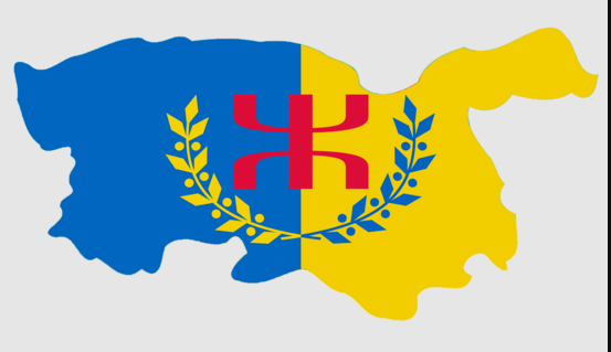
Kabylia (Kabyle: Tamurt n Leqbayel or Iqbayliyen, meaning "Land of the Tribes") is a mountainous coastal region in northern Algeria and the homeland of the Kabyle people. It is part of the Tell Atlas mountain range and is located at the edge of the Mediterranean Sea.
[for further infos about the region you can see the wiki.]
Tour informations:
13 stages
3Mountain
4Hilly
4Flat
1ITT
1TTT
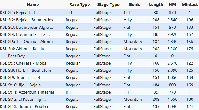
Many GPM's as the region is very mountainous, and 3 IS in every race except the TTs, one at the start, one in the middle, and one in the final, to make the green jersey fight more interesting, and give chances to GC riders to get some bonificcations here and there.
2 of the hard mountain stages are at the end of the first week, while the other mountain and the time trial are at the end of the second week so that the top form isn't obvious and the same for everyone. Same for Sprinter's stages, tried to put them on different days.
Stage1: Team Time Trial of 30km, there are a few 5-7% in the first part of the race, but then flat until the end.
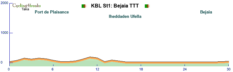
Stage2: Hilly 208km Mintact km196, a few short and steep hills in the middle of the race, but then all flat. Maybe not all the sprinters will be there in the end or maybe a good group can go through if the sprint teams prefer to save energy for the next day. Final5km: +1 0 +1 0 0
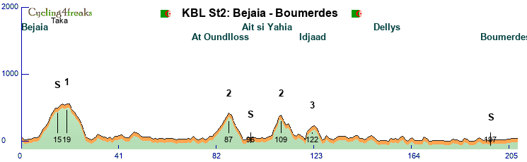
Stage3: Flat 151km Mintact km133, not much to say about this, should be an easy sprint. Final5km: 0 +3 -4 -2 -1
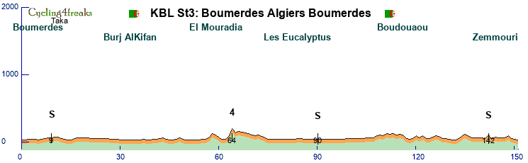
Stage4: Hilly 185km Mintact km157. Not the hardest finish for GC favos but some teams could take adventage of the hilly final.
Hills - Ameur:+8 +5 +4 0 +6 +1 +6 +5. Taourga:+3 +5 +6 +5 +4 +6 +5 +4 +3. Final5km:+4 -1 0 +4 0.
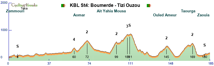
Stage5: Mountain 184km Mintact km155. Most the race is up and down, the hills aren't long but with steep parts.
Hills - Tazert: +8 +7 +10 +9 +4 +9 +6 +4 +3. Tazerout:+7 -9 -2 +6 +4 +6 +4 +2 +3 +7.Arzou:+6 +9 +8 +10 +8 +12 +3 +3 then 3 final km remain after the last GPM: +2 -1 +2.
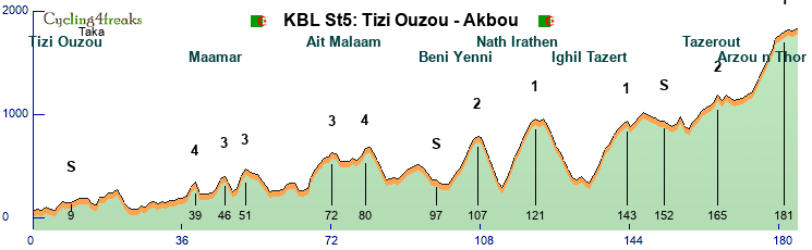
Stage6:Mountain 202km Mintact km175. Last race of the first week and the hardest probably, with less climbs than the previous race, but long ones this time.
Hills -Thalaat:+9 +8 +6 +4 +8 0 +4 +1 +6 +4 +5. Mezrareg: 10* 10* 4* 3* 8* 3** 7** 3** 0 +8. Final5km: +4 +9 -5 -11 -7
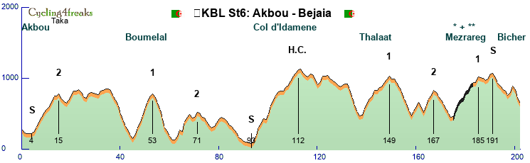
---------------Rest Day-----------------
Stage7: Hilly 160km Mintact km122. The last climb not far from the finish and hard enough to get rid of all the sprinters, then a downhill -4 sprint finish.
Hills- Zemmoura: +6 +8 +8 +11 +10 +9 +10 +3. Final 5km: -2 -3 -2 -2 -4.
Stage8: Hilly 150km Mintact km125. Minor hills in this stage, but the slightly uphill ending makes it interesting.
Final 15km: +4 +7 +2 +1 0 +8 +1 +4 -2 -8 +6 +5 -7 -1 -2
Stage9: Flat 151km Mintact km134. Easy race for the sprint teams. Final5km: +1 -1 0 0 0
Stage10: Flat 184km Mintact km169. Another race for the sprinters while the GC leaders can save up for what's coming. Final 5km: 0 0 0 0 0
Stage11: ITT 39km. The first 27km are flat and for the tt specialist, but then remains le col de Tardam to decide the stage winner. Will be an interesting race, and a great challenge for the GC riders as the hardest mountain race is the next day.
Tardam: +7 +6 +6 +5 +5 +5 +4 +9 +6 +5 +3 +1
Stage12: Mountain 209km Mintact km180. The road goes up from the beginning, the first part is hilly but then comes some flat. The final 70km are ups and downs, the last two hills aren't difficult, but the length of the race and the long tt the day before will have a big impact at the end.
Hills - Mellikech: +6 +9 +10 +8 +7 +4 +7 +4 +1 +5. Thazaghrat: +7 +3 +10 +8 +9 +6 +8 +4.
Stage13: Flat 137km Mintact km121. The final day, and the last chancec for riders to fight for their jerseys. The only hill of the day is easy with just one sieb km, so should end in a mass sprint most likely.
Final 5km: -2 -1 0 0 0
Kabylia (Kabyle: Tamurt n Leqbayel or Iqbayliyen, meaning "Land of the Tribes") is a mountainous coastal region in northern Algeria and the homeland of the Kabyle people. It is part of the Tell Atlas mountain range and is located at the edge of the Mediterranean Sea.
[for further infos about the region you can see the wiki.]
Tour informations:
13 stages
3Mountain
4Hilly
4Flat
1ITT
1TTT
Many GPM's as the region is very mountainous, and 3 IS in every race except the TTs, one at the start, one in the middle, and one in the final, to make the green jersey fight more interesting, and give chances to GC riders to get some bonificcations here and there.
2 of the hard mountain stages are at the end of the first week, while the other mountain and the time trial are at the end of the second week so that the top form isn't obvious and the same for everyone. Same for Sprinter's stages, tried to put them on different days.
Stage1: Team Time Trial of 30km, there are a few 5-7% in the first part of the race, but then flat until the end.
Stage2: Hilly 208km Mintact km196, a few short and steep hills in the middle of the race, but then all flat. Maybe not all the sprinters will be there in the end or maybe a good group can go through if the sprint teams prefer to save energy for the next day. Final5km: +1 0 +1 0 0
Stage3: Flat 151km Mintact km133, not much to say about this, should be an easy sprint. Final5km: 0 +3 -4 -2 -1
Stage4: Hilly 185km Mintact km157. Not the hardest finish for GC favos but some teams could take adventage of the hilly final.
Hills - Ameur:+8 +5 +4 0 +6 +1 +6 +5. Taourga:+3 +5 +6 +5 +4 +6 +5 +4 +3. Final5km:+4 -1 0 +4 0.
Stage5: Mountain 184km Mintact km155. Most the race is up and down, the hills aren't long but with steep parts.
Hills - Tazert: +8 +7 +10 +9 +4 +9 +6 +4 +3. Tazerout:+7 -9 -2 +6 +4 +6 +4 +2 +3 +7.Arzou:+6 +9 +8 +10 +8 +12 +3 +3 then 3 final km remain after the last GPM: +2 -1 +2.
Stage6:Mountain 202km Mintact km175. Last race of the first week and the hardest probably, with less climbs than the previous race, but long ones this time.
Hills -Thalaat:+9 +8 +6 +4 +8 0 +4 +1 +6 +4 +5. Mezrareg: 10* 10* 4* 3* 8* 3** 7** 3** 0 +8. Final5km: +4 +9 -5 -11 -7
---------------Rest Day-----------------
Stage7: Hilly 160km Mintact km122. The last climb not far from the finish and hard enough to get rid of all the sprinters, then a downhill -4 sprint finish.
Hills- Zemmoura: +6 +8 +8 +11 +10 +9 +10 +3. Final 5km: -2 -3 -2 -2 -4.
Stage8: Hilly 150km Mintact km125. Minor hills in this stage, but the slightly uphill ending makes it interesting.
Final 15km: +4 +7 +2 +1 0 +8 +1 +4 -2 -8 +6 +5 -7 -1 -2
Stage9: Flat 151km Mintact km134. Easy race for the sprint teams. Final5km: +1 -1 0 0 0
Stage10: Flat 184km Mintact km169. Another race for the sprinters while the GC leaders can save up for what's coming. Final 5km: 0 0 0 0 0
Stage11: ITT 39km. The first 27km are flat and for the tt specialist, but then remains le col de Tardam to decide the stage winner. Will be an interesting race, and a great challenge for the GC riders as the hardest mountain race is the next day.
Tardam: +7 +6 +6 +5 +5 +5 +4 +9 +6 +5 +3 +1
Stage12: Mountain 209km Mintact km180. The road goes up from the beginning, the first part is hilly but then comes some flat. The final 70km are ups and downs, the last two hills aren't difficult, but the length of the race and the long tt the day before will have a big impact at the end.
Hills - Mellikech: +6 +9 +10 +8 +7 +4 +7 +4 +1 +5. Thazaghrat: +7 +3 +10 +8 +9 +6 +8 +4.
Stage13: Flat 137km Mintact km121. The final day, and the last chancec for riders to fight for their jerseys. The only hill of the day is easy with just one sieb km, so should end in a mass sprint most likely.
Final 5km: -2 -1 0 0 0
-
flockmastoR
- Posts: 3134
- Joined: Thu Feb 18, 2010 11:42 pm
- Contact:
Re: December Tour 2023 - Presentation
CLOSED
Thanks to all participations. Taka a bit late, but good for him I went to bed early. So finally 9 Tours got submitted. I will provide the thread for the first round voting today.
Thanks to all participations. Taka a bit late, but good for him I went to bed early. So finally 9 Tours got submitted. I will provide the thread for the first round voting today.
Boaz Trakhtenbrot:
Schrödinger's Dogs: Alive & Dead
- Winner Giro 2022
- 10 GC wins
- 16.609 Eternal Points
Schrödinger's Dogs: Alive & Dead
Who is online
Users browsing this forum: No registered users and 12 guests