Herzlich Willkommen liebe Pressevertreter und alle Radsportfreaks!
Wir haben sie hier am Rande des Münsterland-Giros eingeladen, weil wir ihnen gleich einen Vorschlag zur Dezember-Tour präsentieren möchten.
Wer sind wir? Das ist einmal das Touristikministerium von Neuseeland und meine Wenigkeit, TJ Düsterwech, der Manager von FSG Sattelpuper. Wir bekammen eine Anfrage, ob wir nicht das Ministerum unterstützen wollten, bei dem Entwurf für eine Rundfahrt durch Neuseeland. Wir fühlten uns natürlich geehrt, da wir erst so kurz dabei sind und schon eine Unterstützung für ein so großes Land sein zu dürfen. Da die Fahrer andersweitig eingespannt sind, viel mir die Aufgabe zu. Ich werde die Präsentation auf Deutsch halten, da wir ja nunmal hier sind und ich auch hier aus dem erweiterten Umfeld stamme, eine Übersetzung werden sie natürlich unten finden, denn der Radsport ist und bleibt international.
Translation:
Welcome dear press representatives and all cycling freaks!
We have invited you here on the fringes of the Münsterland-Giro because we would like to present you with the proposal for the December Tour right away.
Who are we? That is the New Zealand Ministry of Tourism and myself, TJ Düsterwech, the manager of FSG Sattelpuper. We received a request to assist the Ministry in designing a tour of New Zealand. We felt honoured, of course, as we had only been there for such a short time and were already able to support such a large country. As the riders are otherwise engaged, the task fell to me. I will give the presentation in German, since we are here and I also come from the extended environment here. You will of course find a translation below, because cycling is and remains international.
Die Rahmenbedingungen waren leider nicht ganz so schnell abgesteckt, da es doch viele Dörfer und Städte gab, die gerne Etappenort geworden wären. Es musste also eine Auswahl getroffen werden und eine Möglichkeit gefunden werden, um diese Orte mit schönen und interessanten Etappen verbinden zu können. Und dann sollte ja auch noch unterschiedliches Gelände dabei sein. Von Beginn an stand fest, das Auckland der Zielort für die letzte Etappe sein sollte. Wir haben uns dann entschieden am anderen Ende von Neuseeland zu starten, ganz im Süden, in Invercargill und so war auch schon der Name der Tour gefunden:
Neuseeland Süd nach Nord
Translation:
Unfortunately, the framework conditions were not set quite so quickly, as there were many villages and towns that would have liked to become stage locations. So a selection had to be made and a way found to connect these places with beautiful and interesting stages. And then there should also be different terrain. From the beginning, it was clear that Auckland would be the destination for the last stage. We then decided to start at the other end of New Zealand, in the very south, in Invercargill, and so the name of the tour was already found:
New Zealand South to North
Hier nun ein kurzer Überblick über die gesamte Tour, bevor ich die einzelnen Etappen vorstelle. Auf der südlichen Insel haben wir viel flaches und nicht so dicht besiedeltes Land, allerdings auch die neuseländischen Alpen. Da es die größere Insel ist, werden wir hier die ersten sieben Etappen fahren. Dreimal wird es überwiegend flach sein, zweimal warten Hügel in den Etappen, einmal gibt es eine Bergankunft und einmal fahren wir über zwei große Berge. Etapenziele in den Alpen zu finden ist hier sehr schwierig, da es da kaum Dörfer gibt und schon gar keine, die groß genug wären.
Zum Wechsel der Inseln nimmt sich der Radsporttross einen Tag Pause, bevor es in Wellington wieder weitergeht. Auf der nördlichen Insel wartet dann ein Einzelzeitfahren, eine Flachetappe und eine Bergankunft, die restlichen drei Rennen sind hügelig gestaltet. Hier gibt es auch noch einen kleinen Transfer zum Startort, sonst wäre die Bergetappe zu lang geworden.
Insgesamt haben wir somit 13 Etappen und einen Ruhetag und damit den maximalen Rahmen ausgefüllt. In jedem Rennen, ausser dem Zeitfahren, wird es zwei Zwischensprints geben, hierfür dank auch an die beiden Sponsoren. Die Bergwertungen sind natürlich ganz unterschiedlich auf den Etappen verteilt, aber jede Etappe hat mindestens eine. Es wird auch nur die Kategorie 1 erreicht, ganz genaue Vorgaben gab es für die Wertungen nicht, da auch sehr unterschiedliche Steigungen dabei sind, von flachen langen bis hin zu kurzen steilen Anstiegen. Auch die Pave-Spezialisten, haben eine oder eventuell zwei Etappen, die ihnen liegen müsste, bei der dritten sind aber wohl doch klar die Bergflöhe im Vorteil.
Wir hoffen, wir haben die Tour so gestalten können, dass alle Wertungen bis zum letzten Tag spannend bleiben. Dazu müssen natürlich auch möglichst Teams mit verschiedenen Schwerpunkten melden und die passenden Fahrer mitbringen, dass können wir nur in so fern beeinflussen, dass wir für alle passende Etappen dabeihaben und das war unser Ziel.
Translation:
Here is a brief overview of the whole tour before I present the individual stages. On the southern island we have a lot of flat and not so densely populated land, but also the New Zealand Alps. As it is the larger island, we will ride the first seven stages here. Three times it will be mostly flat, twice there will be hills in the stages, once there will be a mountain finish and once we will ride over two big mountains. Finding stage finishes in the Alps is very difficult here, as there are hardly any villages and certainly none that are big enough.
To change islands, the cycling pack takes a day's break before continuing again in Wellington. On the northern island there is an individual time trial, a flat stage and a mountain finish, the remaining three races are hilly. There is also a short transfer to the starting point, otherwise the mountain stage would have been too long.
All in all, we have 13 stages and one rest day, so we have filled the maximum frame. In each race, except for the time trial, there will be two intermediate sprints, thanks to the two sponsors. The mountain classifications are, of course, distributed quite differently over the stages, but each stage has at least one. Only category 1 will be reached, there were no exact specifications for the classifications, as there are also very different climbs, from flat long climbs to short steep climbs. Even the Pave specialists have a stage, or two that should suit them, but the mountain fleas have a clear advantage on the third one.
We hope that we have been able to organise the tour in such a way that all classifications remain exciting until the last day. Of course, we have to register teams with different focuses and bring the right riders, but we can only influence that in so far as we have suitable stages for everyone, and that was our goal.


_________________________________________________________________________________________________________________________
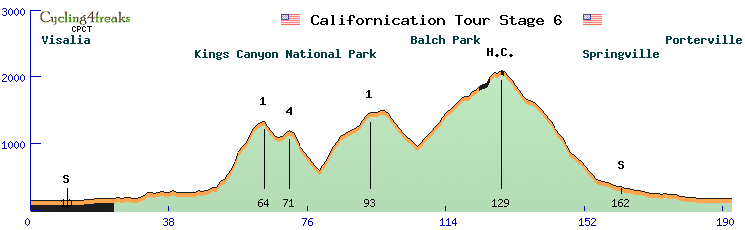
Etappe 1: Invercargill - Dunedin 202 km, Flach
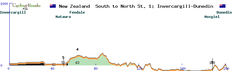
Sprint: km 50, km 188
Mountain: km 63 (4)
Gelände ab km 188: 0/ 2/ 5/ -1/ -2/ -3/ -3/ 1/ 1/ 1/ 2/ 3/ 2/ -5/ -4
min tact: km 186
Wir hatten uns vorgenommen für jede Etappe etwas besonders bieten zu können, auch wenn es nur klein ist. Wir starten mit einer Etappe durch das südliche Flachland, hier war es schon schwer etwas besonderes zu finden. Es ist gleich die längste Etappe, 202 km! Das wars aber nicht, auch dass den Ausreißern wohl nur das Bergtrikot winkt ist hier zu erwarten und bis zum zweiten Zwischensprint gibt es maximal eine 4er Steigung. Die Lage von Dunedin ist etwas besonders, es ist von einem kleinen Hügelring umgeben oder besser es ist ein Tal was im Meer endet. Wir haben hier schon die flacheste Einfahrt gesucht, um nicht den Sprintern in der ersten Etappe den Spaß zu verderben. Die letzten zwei km zum Ziel sind dafür sehr schnell, da es im Schnitt mit 4% bis 5% bergab geht und so einen Bergabsprint, gibt es nur sehr selten.
Translation:
We had planned to offer something special for each stage, even if it is only small. We start with a stage through the southern lowlands, where it was difficult to find something special. It is the longest stage, 202 km! But that's not all, it's also to be expected that the breakaways will only win the mountain jersey, and there is a maximum of one 4-point climb up to the second intermediate sprint. The location of Dunedin is a bit special, it is surrounded by a small ring of hills or rather it is a valley that ends in the sea. We were looking for the flattest entrance so as not to spoil the fun for the sprinters in the first stage. The last two km to the finish are very fast, as the average descent is 4% to 5%, and such a downhill sprint is very rare.
__________________________________________________________________________________________________________________________
Etappe 2: Dunedin - Karow 172 km, Flach
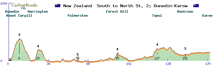
Sprint: km 59, km 151
Mountain: km 9 (3), km 25 (4), km 93 (4), km 124 (4)
Gelände ab km 163: 0/ 0/ -1/ 0/ 0/ +1/ 0/ 0/ 0/ 0
min tact: km 149
Wer in einen Kessel reinfährt, muss auch wieder raus und da haben wir diesmal eine schwere Ausfahrt genommen. 0/ 1/ 3/ 9/ 6/ 7/ 4/ 1/ 4 sind die Steigungen bis zur Bergwertung der Cat. 3 und kurz danach geht es nochmal mit 5/ 9/ 5 zur Bergwertung der Cat. 4. Hier könnte sich schon ein Bergfahrer erstmal das Bergtrikot sichern, wenn er die Körner investieren möchte. Danach wird es wieder flach, maximale Steigung von 5 und am Ende dürften die Sprinter wieder die Nase vorne haben und um das Führungstrikot kämpfen. Landschaftlich wird es sehr schön, erst geht es am Pazifik entlang und zum Ende fährt man dem Lauf des Waitaki River hoch.
Translation:
If you ride into a cauldron, you also have to ride out again and this time we took a difficult exit. 0/ 1/ 3/ 9/ 6/ 7/ 4/ 1/ 4 are the climbs up to the climb classification of Cat. 3 and shortly after that it's another 5/ 9/ 5 to the climb classification of Cat. 4. Here a mountaineer could secure the mountains jersey for the first time if he wants to invest the energy. After that it will be flat again, maximum gradient of 5 and at the end the sprinters will probably be ahead again and fight for the leader's jersey. The scenery is beautiful, first along the Pacific and then up the Waitaki River at the end.
__________________________________________________________________________________________________________________________
Etappe 3: Karow - Geraldine 186 km, Hügel
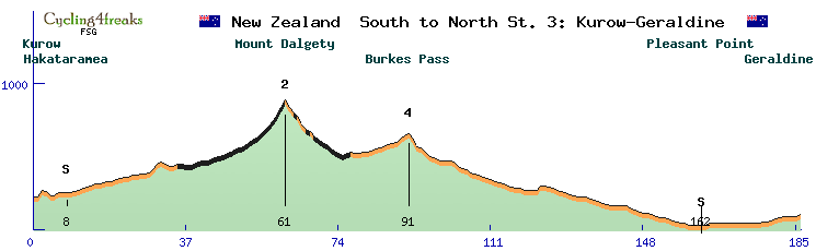
Sprint: km 8, km 162
Mountain: km 61 (2), km 91 (4)
Gravelsection: km 36 - km 77
Gelände ab km 177: +1/ 0/ +1/ +1/ +1/ +1/ 0/ 0/ 0/ +1
min tact: 178
Am dritten Tag kommen wir erstmals ins Alpenvorland und bewältigen einen Ausläufer der Gebirgskette. Im der wenig besiedelten Gegend gibt es nur eine Schotterstraße auf einer Strecke von 40 km, dazu ist die Steigung sehr lang aber auch recht flach, mehr als 5 % werden auf den letzten beiden Kilometern vor der Bergwertung der Cat. 2 nicht erreicht. Danach kommen wir wieder auf die Straße und noch zu einer Bergwertung der Cat. 4, bevor es in der zweiten Hälfte fast nur noch leicht bergab geht. Insgesamt keine wirklich schwere Etappe. Die Pave-Spezialisten haben hier aber als Ausreißer durchaus eine Chance nicht nur das Bertrikot zu holen, sondern auch als erstes das Ziel zu erreichen. Vermutlich werden aber die Sprinterteams nochmal alles daran setzen, es am Ende zu einem Massensprint kommen zu lassen, denn am nächsten Tag wird es dann zu steil für sie und sie müssen das Leadertrikot abgeben.
Translation:
On the third day, we enter the foothills of the Alps for the first time and tackle a foothill of the mountain range. In the sparsely populated area there is only one gravel road over a distance of 40 km, in addition the gradient is very long but also quite flat, more than 5% are not reached on the last two kilometres before the Cat. 2 mountain classification. After that we get back on the road and another Cat. 4 hill classification, before the second half is almost only slightly downhill. All in all, not a really difficult stage. The Pave specialists, however, have a chance as breakaway riders not only to win the moutain jersey, but also to reach the finish first. But probably the sprinterteams will do everything they can to make it a mass sprint at the end, because the next day it will be too steep for them and they will have to give up the leader's jersey.
__________________________________________________________________________________________________________________________
Etappe 4: Geraldine - Porters Pass 187 km, Berg
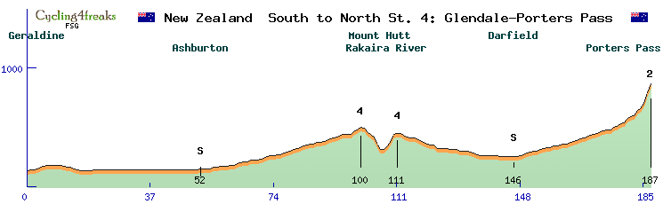
Sprint: km 52, km 146
Mountain: km 100 (4), km 111 (4), km 187 (2)
Gelände ab km 178: +2/ +1/ +3/ +2/ +1/ +4/ +2/ +4/ +9/ +8
min tact: 175
Auf der sehnsüchtig von den Bergfahrern erwarteten vierten Etappe geht es zunächst aber ins Flachland. Über Ashburton und einen Zwischensprint fährt das Feld in Richtung Mount Hutt. Kurz vor dem Berg, biegen wir rechts ab und überqueren den großen Rakaira Fluß, der sich tief ins Gestein gefräst hat. Das leicht ansteigende Gelände führt zur Cat. 4 Bergwertung, dann geht es in die Schlucht hinunter und über die fast 200 Meter lange Flußbrücke bevor es zwei Kilometer lang mit einer 5er Steigung wieder raus geht. Hier ist die nächste Cat. 4 Wertung. Nach einen Schlenker um die Gebirgsausläufer geht es dann hoch zum Porters Pass, wo am Aussichtspunkt genug Platz für eine Zielankunft war. Dort wartet nicht nur die Siegerprämie, sondern auch das Geld für die Cat. 2 Bergwertung. Für das Führungstrikot wird es vorausichtlich für den Ersten reichen, dass Bergtrikot wird er aber wohl nicht in Empfang nehmen dürfen und so sollten die Wertungstrikots auf drei verschiedenen Schultern ruhen. Landschaftlich gesehen, die bisher schönste Etappe, wofür die Fahrer wohl keine Zeit haben dürften diese zu bewundern, denn die Kapitäne und Favoriten auf den Gesamtsieg werden sich hier in Stellung bringen und da es doch erst recht lang flach ist, werden die Helfer auch zu tun bekommen. Der für eine Bergankunft nicht allzusteile und kurze Anstieg wird noch keine großen Abstände zulassen, aber man wird sehen, wer die Form mitbringt um hier um den Toursieg mitfahren zu können.
Translation:
On the fourth stage, which is eagerly awaited by the mountain riders, it's first the flat country. Via Ashburton and an intermediate sprint, the peloton heads towards Mount Hutt. Just before the mountain, we turn right and cross the big Rakaira River, which has cut deep into the rock. The slightly uphill terrain leads to the Cat. 4 hill climb, then we descend into the gorge and cross the almost 200 metre long river bridge before heading out again for two kilometres with a 5 grade. Here is the next Cat. 4 classification. After a detour around the foothills, it's up to Porters Pass, where there was enough room for a finish at the viewpoint. There, not only the winner's bonus awaits, but also the money for the Cat. 2 mountain classification. It will probably be enough for the leader's jersey for the first rider, but he will probably not be allowed to take the mountain jersey and so the classification jerseys should rest on three different shoulders. From a scenic point of view, this is the most beautiful stage so far, but the riders probably won't have time to admire it, because the captains and favourites for the overall victory will get into position here and since it is flat for quite a long time, the helpers will also have their work cut out for them. The climb, which is not too steep and short for a mountain finish, will not allow for large gaps, but we will see who has the form to compete for the Tour victory.
__________________________________________________________________________________________________________________________
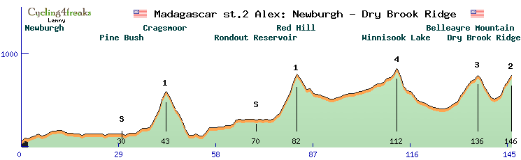
Etappe 5: Darfield - Christchurch 189 km, Hügel
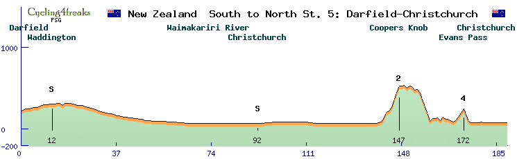
Sprint: km 12, km 92
Mountain: km 147 (2), km 172 (4)
Gelände ab km 180: -1/ 0/ 0/ 0/ 0/ 0/ 0/ 0/ 0/ 0
min tact: 164
Nachdem der Tourtross von Porters Pass wieder nach Darfield runtergekommen ist, wird auch hier die 5. Etappe gestartet. Endlich geht es in die größte Stadt der Südinsel, Christchurch. Zunächst werden wir aber einen Zwischensprint in Sheffield einlegen und dann den nächsten großen Fluß überqueren. An einem kleinen Fluß entlang fahren wir dann schnurgerade dem Meer entgegen. Zu besichtigen gibt es hier - Schafe, eine Menge Schafe. Bevor wir leider nicht baden gehen können, geht es rechts ab wieder über den Waimakariri Fluß nach Christchurch rein, wo uns ein Sprint erwartet, denen die Sprinter schon gerne als Ziel hätten. Da aber erst 91 flache Kilometer gefahren sind und wir den Zuschauern noch was bieten wollen, geht die Strecke wieder raus aus Christchurch und macht eine Runde über die Vorstädte um dann vom südosten wieder in die Stadt zu kommen. Und hier liegt das Problem der Sprinter, die knapp 500 Meter hohe Hügelkette die erklimmt werden muss. Ab km 141, haben wir Steigungen von 5/ 6/ 3/ 4/ 10/ 8/ 8 um Coopers Knob (Mountian Cat. 2) zu erreichen. Nach einer kurzen Strecke auf dem Kamm, geht es runter ans Meer und dann nochmal über den Engers Pass bei km 170 - 172 mit den Steigungen 4/ 5/ 5 (Mountain Cat. 4) nach Christchurch rein. Die Sprintspezialsten werden dann nicht mehr vorne dabei sein, für die Bergflöhe wird es auf den letzten flachen 15 km auch schwer werden, denn hier werden die Fahrer mit beiden Skills wahrscheinlich die Nase vorne haben.
Translation:
After the Tourtross has come back down from Porters Pass to Darfield, the 5th stage starts here as well. At last we are heading for the largest city in the South Island, Christchurch. But first we will have an intermediate sprint in Sheffield and then cross the next big river. Along a small river we drive straight towards the sea. There is something to see here - sheep, lots of sheep. Before we unfortunately can't go swimming, we turn right again across the Waimakariri River into Christchurch, where a sprint awaits us, which the sprinters would like to have as a finish. But since we have only ridden 91 flat kilometres and we still want to give the spectators something to watch, the route goes out of Christchurch again and does a lap of the suburbs to then come back into the city from the south-east. And here lies the problem for the sprinters, the almost 500 metre high hill range that has to be climbed. From km 141, we have climbs of 5/ 6/ 3/ 4/ 10/ 8/ 8 to reach Coopers Knob (Mountian Cat. 2). After a short stretch on the ridge, it's down to the sea and then again over Engers Pass at km 170 - 172 with gradients of 4/ 5/ 5 (Mountain Cat. 4) into Christchurch. The sprint specialists will then no longer be at the front, it will also be difficult for the mountain fleas on the last flat 15 km, because here the riders with both skills will probably have their noses in front.
__________________________________________________________________________________________________________________________
Etappe 6: Christchurch - Hanmer Springs 153 km, Flach
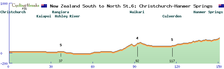
Sprint: km 37, km 117
Mountain: km 92 (4)
Gelände ab km 142: -1/ 0/ 0/ -1/ +1/ +1/ 0/ +1/ +1/ +2
min tact: 138
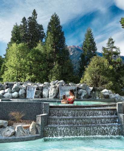
Die 6. Etappe könnte auch für gute Amateurfahrer eine schöne Strecke mit einem lohnenden Ziel sein. Es geht von Christchurch nach Hanmar Springs, hier könnte man im Winter mit Sicherheit Ski fahren, aber das ganze Jahr geben die warmen und heissen Quellen ihr Wasser in denen man sehr gut entspannen kann. Die kurze Strecke ist was für die Sprinter, es geht nie mehr als 3% hoch, nur der Zielsprint steigt auch 2% an. Nach dem ersten Zwischensprint in Rangiora geht es über den nächsten großen Fluß, den Ashley River. Eine echte Bergwertung gibt es eigentlich nicht, obwohl wir im Alpenvorland unterwegs sind, trotzdem ist mit einem hohen Tempo zu rechnen, denn Zeit haben die Fahrer nach dem Rennen kaum, um sich in den Quellen zu entspannen. Es steht noch ein Transport von 250 km an und am nächsten Tag wartet die Königsetappe, da müssen alle wieder fit sein.
Translation:
Stage 6 could also be a nice route for good amateur riders with a rewarding finish. It goes from Christchurch to Hanmar Springs, here you could ski in winter for sure, but all year round the warm and hot springs give their water in which you can relax very well. The short course is something for sprinters, it never goes up more than 3%, only the finish sprint also goes up 2%. After the first intermediate sprint in Rangiora, the route crosses the next big river, the Ashley River. There is actually no real mountain classification, even though we are in the foothills of the Alps, but you can still expect a fast pace, because the riders hardly have time to relax in the springs after the race. There is still a transport of 250 km to go and the next day the queen stage is waiting, everyone has to be fit again.
__________________________________________________________________________________________________________________________
Etappe 7: Blenheim - Richmond 138 km, Berg
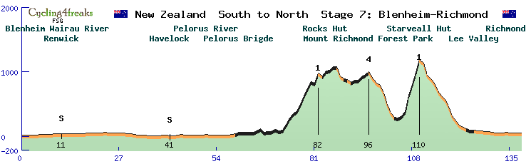
Sprint: km 11, km 41
Mountain: km 82 (1) ( +9/ +10/ +6/ +5/ +10/ +13/ +11/ +11/ -2/ +15)
km 96 (4)
km 110 (1) ( +3/ +7/ +25/ +18/ +17/ +20)
Gravelsection: km 60 - km 125
Gelände ab km 129: 0/ -1/ -1/ 0/ 0/ +1/ -1/ 0/ 0/ 0
min tact: 104
Die Köningsetappe! Nicht nur von den Steigungen und der Höhe, es ist auch landschaftlich die schönste Etappe und dazu ist sie auch noch die Kürzeste mit 138 km. Es gibt soviele taktische Möglichkeiten für die verschiedenen Teams, dass ich hoffe, dass es auch die spannenste Etappe der Tour wird. Was man wohl schon mit Sicherheit sagen kann, wer am Ziel nicht in einer der vorderen Gruppen ist, kann den Gesamtsieg abschreiben, denn hier könnten schon große Zeitabstände entstehen und die Fahrer müssen aufpassen, dass sie am Ende nicht aus der Karrenzzeit fallen, das begrenzt vielleicht auch die Aktivitäten am Anfang und die taktische Auswahl der Teams. Gestartet wird in Blenheim, nach 11 km gibt es den ersten Zwischensprint, den sich vielleicht die Sprinter noch holen möchten, wenn ihre Teams das Feld bis dahin zusammenhalten können. Nachdem dann der Wairau River überquert ist, geht es in eine Art Schlucht ganze 25 flache Kilometer durch die Alpen nach Havelock zum zweiten Zwischensprint bei km 41. Es wird sich zeigen, ob sich da schon eine Ausreißergruppe gebildet hat, Kandidaten dafür wären Dockstationen für die Kapitäne, Bergpunktejäger und auch Sprinter für die Punkte in Havelock, dass Ausreißer eine Chance auf den Etappensieg haben, würde ich an diesem Tag bezweifeln. Allerdings wird es auch genügend Teams geben, die diese Kandidaten gar nicht erst weg lassen wollen, daher kann es auch sein, dass das Peloton noch geschlossen hier ankommt. Danach geht es 30 sehr sehenswerte Kilometer am Fluss Te Hoiere entlang, der mit Sicherheit zum Baden einlädt. An der Pelrous Brigde biegen die Fahrer dann vom Asphalt auf den Schotter ab. Nun kommt die Zeit der Pavespezialisten, um groß Vorsprung rauszufahren, dürfte der flache Teil aber zu kurz sein. Die 10 km hoch zum Rocks Hut (Cat. 1) haben dann im Durchschnitt 9% Steigung, oben wird man dann mit einer schönen Aussicht belohnt. Ob dort noch Ausreißer vorne sein werden, ist hier einer der spannenden Fragen. Auf dem Gebirgskamm entlang geht es dann hoch und runter. Ab km 97 geht es dann bergab um 2 km dem Miner River zu folgen. Danach kommt der knackige Anstieg zum Starveall (Cat. 1) erst zwei Kilometer seicht, aber die vier folgenden Kilometer haben eine durchschnittliche Steigung von 20%. Der ganze Bergereich führt duch den Mount Richmond Forest Park, aber dafür dürften die Fahrer keine Augen haben. Nach der steilen Abfahrt sind aber noch ca. 15 km im flachen zu absolvieren bevor man die Ziellinie in Richmond passieren kann. Hier wird man sehen, welche Bergfahrer noch genügend Kraft haben die Strecke alleine oder in einer kleinen Gruppe zu meistern. Es könnte aber auch sein, das die besten Hüegelspezialisten noch aufschließen und ein Wörtchen um den Tagessieg mitreden wollen. Ist die anstrengende Etappe geschafft, wartet auch noch der Rücktransport nach Blenheim, wo man wenigsten dann ein zweites mal im gleichen Bett schlafen kann, bevor es am folgenden Tag mit der Fähre auf die nördliche Insel nach Wellington geht.
Translation:
The kings stage! Not only because of the climbs and the altitude, it is also the most beautiful stage in terms of scenery, and it is also the shortest at 138 km. There are so many tactical possibilities for the different teams that I hope it will also be the most exciting stage of the Tour. What you can say for sure is that if you are not in one of the front groups at the finish, you can write off the overall victory, because there could be big time gaps and the riders have to be careful not to fall behind at the end, which might also limit the activities at the start and the tactical choices of the teams. The start is in Blenheim, after 11 km there is the first intermediate sprint, which the sprinters might want to take if their teams can keep the field together until then. After the Wairau River is crossed, the route goes into a kind of gorge for a whole 25 flat kilometres through the Alps to Havelock for the second intermediate sprint at km 41. It remains to be seen whether a breakaway group has already formed, candidates for this would be docking stations for the captains, mountain point chasers and also sprinters for the points in Havelock, that breakaways have a chance of winning the stage, I would doubt on this day. However, there will also be enough teams who don't want to let these candidates get away at all, so it's also possible that the peloton will still arrive here united. After that, it's 30 kilometres along the Te Hoiere river, which is well worth seeing and certainly invites you to take a swim. At the Pelrous Brigde, the riders turn off the asphalt onto the gravel. Now it's time for the pavement specialists, but the flat part might be too short to gain a big lead. The 10 km up to the Rocks Hut (Cat. 1) have an average gradient of 9%, at the top you are rewarded with a beautiful view. Whether there will be any breakaways at the front is one of the exciting questions here. The course goes up and down along the ridge. From km 97 onwards, the route goes downhill to follow the Miner River for 2 km. Then comes the crisp climb up to Starveall (Cat. 1), shallow for two kilometres at first, but the four kilometres that follow have an average gradient of 20%. The whole mountain section passes through Mount Richmond Forest Park, but riders may not have eyes for that. After the steep descent, however, there are still about 15 kilometres of flat riding to be done before passing the finish line in Richmond. Here we will see which climbers still have enough strength to master the course alone or in a small group. But it could also be that the best hill specialists will catch up and want to have a say in the day's victory. Once the strenuous stage is over, the transport back to Blenheim awaits, where you can at least sleep in the same bed for a second time before taking the ferry to the northern island of Wellington the following day.
==========================================================================================================================
Es folgt ein Ruhetag, der genutzt wird, damit der Renntross von der Südinsel zur Nordinsel nach Wellington umziehen kann.
Translation:
A rest day follows, which is used so that the race pack can move from the South Island to the North Island in Wellington.
==========================================================================================================================
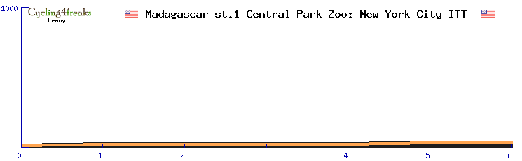
Etappe 8: Wellington - Lower Hutt 25 km, ITT
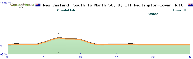
Mountain: km 7 (4)
Gelände km 5 - 12: +5/ +6/ +4/ -2/ 0/ -2/ -6/ -5
min tact: 1
Ein mittleres Einzeitfahren eröffnet am ersten Tag auf der Nordinsel die Möglichkeit eines Wechsels in der Gesamtwertung. Hier werden sich vorallem die Favoriten und die Spezialisten reinhängen, der Rest wartet auf Chancen in anderen Etappen. Der Start ist in Wellington, der Stadt, die in Neuseeland für Profiradrennsport steht wie keine andere. Los geht es am Hafen, mit einem kleinen Schlenker für die Bergwertung (Cat. 4), läuft die Etappe Richtung Lower Hutt, wo auch schon das Ziel nach 25 km wartet.
Translation:
A medium time trial on the first day on the North Island opens up the possibility of a change in the overall classification. This is where the favourites and the specialists will put in the work, the rest will wait for their chances in other stages. The start is in Wellington, the city that stands for professional cycling in New Zealand like no other. It starts at the harbour, with a small detour for the mountain classification (Cat. 4), the stage runs towards Lower Hutt, where the finish is already waiting after 25 km.
__________________________________________________________________________________________________________________________
Etappe 9: Lower Hutt - Palmerston North 182 km, Flach
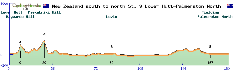
Sprint: km 85, km 167
Mountain: km 9 (4), km 29 (4)
Gelände ab km 173: 0/ 0/ 0/ 0/ 0/ 0/ 0/ 0/ 0/ 0
min tact: 166
Die letzte Etappe für die reinen Sprinter, dürfte die 9. sein. Von Lower Hutt geht es zwar am Anfang über zwei Hügel (Cat. 4), der Rest ist aber fast flach, nur noch ein kleiner Hügel wartet kurz vor dem zweiten Zwischensprint in Fielding, aber dieser hat keine nennswerte Steigung. Anders sieht das bei Haywards Hill bei km 9 aus, da sind 6% und 8% zu bewältigen, der Paekakriki Hill hat maximal 5% Steigung und danach folgt nur noch bei km 37 eine Steigung mit 6%. Insgesamt also ehr eine leichte Etappe, die Sprinterteams haben genug Zeit die Ausreißer wieder einzufangen. Der Wind könnte eine Rolle spielen, denn die meiste Zeit geht es am Meer entlang. In Palmerston North erwartet uns dann ein ganz flacher Sprint. duch die windgeschützten Straßenschluchten, könnte es am Ende durchaus nochmal Attacken geben, da müssen die Sprinterteams das Tempo richtig hochhalten, damit sie am Ende den Tagessieg unter sich ausmachen.
Translation:
The last stage for the pure sprinters should be the 9th. From Lower Hutt there are two hills at the beginning (Cat. 4), but the rest is almost flat, only one small hill awaits shortly before the second intermediate sprint in Fielding, but this one has no significant gradient. The situation is different at Haywards Hill at km 9, where there is a 6% and 8% gradient, Paekakriki Hill has a maximum gradient of 5% and after that there is only a 6% gradient at km 37. All in all it's an easy stage, the sprinters have enough time to catch the escapees. The wind could play a role, as most of the stage goes along the sea. In Palmerston North, a very flat sprint awaits us. Due to the wind-protected road canyons, there could be attacks at the end, where the sprinter teams have to keep the pace really high, so that they can decide the day's victory among themselves at the end.
__________________________________________________________________________________________________________________________
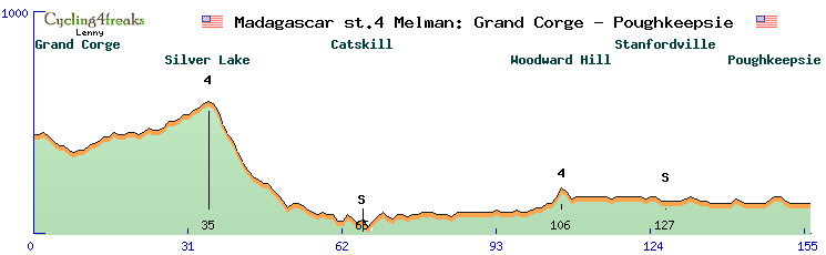
Etappe 10: Mangaweka - Whakapapa 166 km, Berg
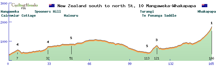
Sprint: km 51, km 113
Mountain: km 7 (4), km 32 (4), km 121 (3), km 166 (1)
Gelände ab km 151: +2/ +2/ +3/ +4/ +4/ +2/ +5/ +6/ +5/ +6/ +6/ +8/ +7/ +8/ +9/ +13
min tact: 150
Auf der 10. Etappe wird es wohl eine Vorentscheidung über den Gesamtsieg geben, denn danach ist es schwer noch größere Zeitrückstände gut zu machen besonders für die Bergfahrer, die Hügelspezialisten haben noch mehr Chancen mal ein paar Sekunden zu gewinnen. Es geht auf den Mount Ruapehu, an seiner Nordseite liegt das Skigebiet um Whakapapa, welches unser Ziel sein wird. Zunächst müssen aber vor dem Startschuss die 80 km auf vier Rädern zum Startort bewältigt werden. Auf hügeligen Gelände starten wir in Mangaweka, nach 7 km warte schon die erste Bergwertung der Cat. 4, nach 32 km auf Spooners Hill kommt die nächste, hier sind auch schon 9% zu bewältigen. Die schöne Hügellandschaft und verschiedene Flüsse begleiten uns bis zum Zwischensprint in Waiouru. Auf der Strecke südöstlich am Mount Ruapehu und am Mount Ngauruhoe vorbei, zum zweiten Zwischensprint nach Turangi ist es nicht wirklich flach, erst geht es mehrheitlich bergauf und dann wieder runter. Am Te Ponanga Saddle (Mountian Cat. 3) geht es dann schon zur Sache, auf sechs Kilometer mit 6/ 7/ 9/ 5/ 7/ 3% Steigung könnten hier die Helfer fürs Flache abgeschüttelt werden. Nach einer kurzen Abfahrt, fängt das Gelände seicht an zu steigen. Wenn wir dann links abbiegen und den Highway 47 Richtung Vulkan verlassen, geht es nur noch bergauf und die Steigungen nehmen immer mehr zu. Der letzte Kilometer hat 13%, hier sollte die Vorentscheidung um den Gesamtsieg fallen, da heisst es den richtigen Moment für die Attacke erwischen.
Translation:
On the 10th stage there will probably be a preliminary decision about the overall victory, because after that it is difficult to make up more time gaps, especially for the mountain riders, the hill specialists have even more chances to gain a few seconds. We are heading up Mount Ruapehu, on its northern side lies the ski area around Whakapapa, which will be our destination. But first we have to cover the 80 km on four wheels to the starting point before the starting gun. We start on hilly terrain in Mangaweka, after 7 km the first mountain classification of Cat. 4 is waiting for us, after 32 km on Spooners Hill the next one is coming, here we already have to cope with 9%. The beautiful hilly landscape and various rivers accompany us until the intermediate sprint in Waiouru. On the route southeast past Mount Ruapehu and Mount Ngauruhoe, to the second intermediate sprint to Turangi it is not really flat, first it is mostly uphill and then down again. At Te Ponanga Saddle (Mountian Cat. 3) it's already getting down to business, on six kilometres with 6/ 7/ 9/ 5/ 7/ 3% gradients the helpers for the flat could be shaken off here. After a short descent, the terrain begins to climb gently. When we then turn left and leave Highway 47 towards the volcano, it is all uphill and the gradients increase more and more. The last kilometre has 13%, here the preliminary decision for the overall victory should be made, so we have to catch the right moment for the attack.

__________________________________________________________________________________________________________________________
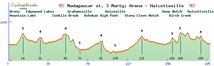
Etappe 11: Torangi - Rotorua 167 km, Hügel
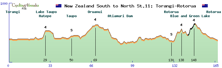
Sprint: km 50, km 130
Mountain: km 29 (4), km 69 (4), km 138 (4), km 148 (4)
Gravelsection: km 144 - km 149
Gelände ab km 158: -2/ -2/ -1/ -2/ 0/ 0/ -1/ -1/ -1/ -1
min tact: 144
Heute könnte der Tag der Ausreißer sein. Eine Vorentscheidung ist im Gesamtklassement gefallen und für die Sprinter dürfte die Etappe zu schwer sein. Besonders der letzte Hügel hat es in sich, da es hier nochmal auf Schotter geht und sollte das Feld hier geschlossen ankommen, gäbe es mit Sicherheit Attacken. Gestartet wird in Torangi, den Ort kennen wir ja noch vom Zwischensprint gestern. Entlang des wunderschönen Lake Taupo liegt die erste Bergwertung (Cat. 4) in Hatepe, die mit 6% und 5% Steigung auf zwei Kilometer bewältigt werden muss. In Taupo angekommen gibt es den ersten Zwischensprint. Dann geht es vom See weg ins hügelige Land, ein flacher Anstieg bei Oruanui bringt die nächste Bergwertung (Cat.4). Vorbei am Atiamuri Dam, folgen wir dem Weg nach Rotorua, dort angekommen gibt es bei km 130 die nächste Sprintwertung. Anschließend wird noch ein Schleife um den Whakarewarewa Forest Park und den blauen und grünen See gemacht bevor es in Rotorua zum Zielsprint kommt. Auf der Schleife warten zwei weitere Bergwertungen (Cat. 4) und bei km 133 - 135 eine Steigung von 5/ 6/ 4% und bei km 144 -149 auf Schotter nochmal 2/ 9/ 0/ 4/ 5/ 0%. Dies gibt vielleicht den einen oder anderen Hügelfahrer die Möglichkeit einen Angriff zu starten um noch ein paar Sekunden gewinnen.
Translation:
Today could be the day of the escapees. A preliminary decision has been made in the overall classification and the stage might be too difficult for the sprinters. Especially the last hill is a challenge, because here it's gravel again and if the peloton arrives here united, there would be attacks for sure. The start is in Torangi, a place we know from yesterday's intermediate sprint. Along the beautiful Lake Taupo lies the first mountain classification (Cat. 4) in Hatepe, which has to be mastered with 6% and 5% gradient over two kilometres. Arriving in Taupo there is the first intermediate sprint. Then it's off the lake into hilly country, a flat climb at Oruanui brings the next mountain classification (Cat.4). Passing the Atiamuri Dam, we follow the road to Rotorua, where the next sprint classification is at km 130. Afterwards we will do a loop around Whakarewarewa Forest Park and the blue and green lake before the finish sprint in Rotorua. On the loop two more mountain classifications (Cat. 4) are waiting and at km 133 - 135 a climb of 5/ 6/ 4% and at km 144 -149 on gravel another 2/ 9/ 0/ 4/ 5/ 0%. This might give the one or other hill rider the opportunity to start an attack to gain a few more seconds.

__________________________________________________________________________________________________________________________
Etappe 12: Rotorua - Hamilton 161 km, Hügel
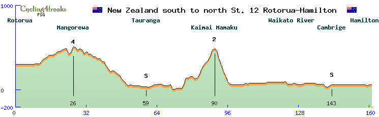
Sprint: km 59, km 143
Mountain: km 26 (4), km 90 (2)
Gelände ab km 152: 0/ 0/ 0/ 0/ 0/ 0/ 0/ -1/ +1/ 0
min tact: 142
Bei der vorletzten Etappe von Rotorua über Tauranga nach Hamilton könnten wieder viele Szenarien entstehen, jenachdem wie es bei den Trikotwertungen aussieht. Dies beeinflusst auch ganz stark die Chancen der Ausreißer, denn die erste Hälfte des Rennens ist hügelig, die Zweite ist flach. Geht es in der Sprintwertung eng zu, wird zum Ende wohl viel Tempo gemacht. Aber fangen wir vorne an. Der erste Zwischensprint ist in Tauranga, welches von Hügeln umgeben ist. Die Hinfahrt ist etwas flacher, hier wartet die Bergwertung (Cat. 4) an einer 7% Steigung bei Mangorewa. Die Ausfahrt wird schwerer, daher gibt es auch eine Bergwertung der Cat. 2 mit 10 Punkte für den Ersten. Diese können auch sehr wichtig für das Bergtrikot sein. Die Steigung zieht sich über einige km hin, dabei wird es am steilsten bei km 89 mit 7% und bei den km 77 und 84 mit 8% bevor es nach km 90 recht steil wieder ins Flachland geht. Auf der Fahrt nach Hamilton begleitet uns der Waikato River über etliche Kilometer und 18 km vor dem Ziel kommt es nochmal zu einem Zwischensprint in Cambridge. Was uns dann genau auf der Zielgeraden in Hamilton erwartet, kann ich jetzt unmöglich voraussagen.
Translation:
In the penultimate stage from Rotorua via Tauranga to Hamilton, many scenarios could arise again, depending on how the jersey rankings look. This also strongly influences the chances of the escapees, because the first half of the race is hilly, the second half is flat. If it's close in the sprint classification, there will probably be a lot of speed at the end. But let's start at the front. The first intermediate sprint is in Tauranga, which is surrounded by hills. The outward leg is a bit flatter, here the mountain classification (Cat. 4) awaits at a 7% climb near Mangorewa. The exit will be harder, so there is also a Cat. 2 hill classification with 10 points for the first. These can also be very important for the mountains jersey. The climb continues for a few kilometres, getting steepest at km 89 with 7% and at km 77 and 84 with 8% before it gets quite steep again after km 90. On the way to Hamilton the Waikato River accompanies us for several kilometres and 18 km before the finish there is another intermediate sprint in Cambridge. It is impossible for me to predict exactly what awaits us on the home stretch in Hamilton.
__________________________________________________________________________________________________________________________
Etappe 13: Hamilton - Auckland 186 km, Hügel
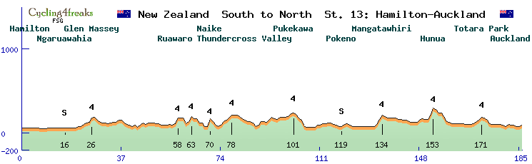
Sprint: km 16, km 119
Mountain: km 26 (4), km 58 (4), km 63 (4), km 70 (4), km 78 (4), km 101 (4), km 134 (4), km 153 (4), km 171 (4)
Gelände ab km 177: 0/ 0/ -1/ -1/ +2/ -1/ 0/ -1/ 0/ +1
min tact: 168
Die 13. und letzte Etappe führt von Hamilton nach Auckland. Hier werden die letzten Entscheidungen in den jeweiligen Klassements fallen. Es wäre jetzt ein leichtes gewesen, eine schöne Flachetappe auf dem Highway 1 zu organsieren, wie es sie z.B. in Paris bei der Tour gibt. Aber wir haben hier keine Tour de France und wir wollten den Zuschauern nochmal was bieten und den Fahrern nochmal eine Chance geben ihr können zu zeigen. Daher sind etliche Hügel auf dem Weg nach Auckland zu überfahren. Dementsprechend viele Bergwertungen gibt es auch, 9 Stück der Cat. 4, was bedeutet, dass es noch 27 Bergpunkte zu holen gibt. Ich kann mir zwar nicht vorstellen, dass ein Fahrer alle bekommt, aber vermutlich wird der finale Träger des Bergtrikos erst am Ende dieser Etappe feststehen. Es gibt viele kurze Anstiege zu bewältigen 5% bei km 26, 75, 89 und 134, 6% bei km 63, 133 und 152, 7% bei km 58, 8% bei km 153 und 9% bei km 70. Dieses rauf und runter wird den reinen Sprintern nicht schmecken, vielleicht schaffen sie es aber durch gute Teamarbeit den Anschluss zu halten. Sonst gäbe es noch die Chance auf den ersten flachen 20 km den Zwischensprint in Ngaruawahia zu gewinnen. Der zweite Zwischensprint bei km 119 in Pokeno liegt zwischen den ganzen Anstiegen und wird wohl an Ausreißer gehen. Ab km 154 warten keine steileren Anstiege mehr, hier ist dann die Frage, welche Sprinter noch in Reichweite des Pelotons sind und wer abgehängt ist, denn bei km 153 wird das Feld mit Sicherheit nochmal auseinandergerissen. Vermutlich wird dann eine größere oder große Gruppe zum Sprint in Auckland antreten.
Translation:
The 13th and final stage leads from Hamilton to Auckland. Here the last decisions in the respective classifications will be made. It would have been easy to organise a nice flat stage on Highway 1, like the ones in Paris at the Tour. But we don't have a Tour de France here and we wanted to offer the spectators something and give the riders another chance to show their skills. That's why there are a lot of hills on the way to Auckland. Accordingly, there are many hill classifications, 9 of them of the Cat. 4, which means that there are still 27 hill points to get. I can't imagine that one rider will get all of them, but probably the final bearer of the mountain trike will only be known at the end of this stage. There are a lot of short climbs - 5% at 26km, 75km, 89km and 134km, 6% at 63km, 133km and 152km, 7% at 58km, 8% at 153km and 9% at 70km. This up and down will not be to the liking of the pure sprinters, but maybe they will manage to keep up with them through good teamwork. Otherwise, there would still be a chance to win the intermediate sprint in Ngaruawahia on the first flat 20 km. The second intermediate sprint at 119km in Pokeno is located between the climbs and will probably go to the escapees. From km 154 onwards there are no steep climbs, so the question is which sprinters are still within reach of the peloton and who is left behind, because at km 153 the peloton will surely be torn apart again. Probably a bigger or larger group will then start the sprint in Auckland.
__________________________________________________________________________________________________________________________
Dies soll es erstmal gewesen sein mit unserer Präsentation. Ich hoffe sie hat ihnen gefallen und wenn unsere Tour gewählt wird, dass wir eine sehr spannende Rundfahrt erleben, am besten erst mit den Entscheidungen in jeweiligen Klassements auf der letzten Etappe. Noch Fragen? Ja - Welchen Rennfahrertyp ich als Favorit auf die jeweiligen Trikots sehe. Nun bei dem Sprinttrikot wird es eng werden, ob ein reiner Sprinter oder ein Hügelsprinter das Trikot holt, mit einem guten Team, würde ich aber auf einen reinen Sprinter tippen. Das Bergtrikot sehe ehr nicht bei einem Bergfahrer, es sei denn, es dominiert ein Fahrer alles, dort gibt es aber mehr als genug kleine Wertungen auf den verschiedenen Etappen zu holen, dass ich hier einen Hügelspezialisten vorne sehe. Das weiße Trikot dürfte an einen jungen Bergfahrer gehen. Das Gesamtwertung werden wohl die Rundfahrer unter sich ausmachen, ohne einen guten Bergskill geht zwar nichts, aber wer nicht auch beim Zeitfahren eine gute Leistung zeigt, dürfte da die entscheidenden Sekunden verlieren.
Vielen Dank für ihre Aufmerksamkeit!
Translation:
This should be it for now with our presentation. I hope you enjoyed it and if our tour is chosen, that we will experience a very exciting tour, preferably with the decisions in the respective classifications on the last stage. Any questions? Yes - Which type of racer I see as favourite for the respective jerseys. Well, for the sprint jersey it will be tight whether a pure sprinter or a hill sprinter will get the jersey, but with a good team I would bet on a pure sprinter. I don't see the mountain jersey going to a mountain rider, unless one rider dominates everything, but there are more than enough small scores on the different stages that I see a hill specialist in front. The white jersey should go to a young climber. The overall classification will probably be decided by the cyclists themselves, without good climbing skills nothing will work, but if you don't also show a good performance in the time trial, you will probably lose the decisive seconds.
Thank you for your attention!


 ***
*** ***
***
 2
2
 4
4
 6
6
 8
8
 10
10
 I'll block it - hehe.
 I am on the way. I´m on my way, pffff....
 ***
***

 ***
***