The thread for the proposed tours. No discussion, no comments, no complaints here, just the tours.
1 post per tour.
Post your tours until the end of the month, 31st October!
Praise, criticism, whining, advertising and whatever else you might want to do in this thread:
http://www.radsportfreaks.de/RSFForum/v ... =14&t=7777
December Tour 2020: Presentation
Moderators: systemmods, Calendarmods
December Tour 2020: Presentation
Kraftsystemrevision! Include the distance!
Basics reform: Give blue a chance!
Don't punish bugusers. We all have to use bugs, since most of them are declared as "features"!
Basics reform: Give blue a chance!
Don't punish bugusers. We all have to use bugs, since most of them are declared as "features"!
-
Gipfelstuermer
- Posts: 1532
- Joined: Wed Jul 13, 2011 10:43 am
- Location: Weltenbummler
- Contact:
Re: December Tour 2020: Presentation
 Humuhumunukunukuapuaa Tour
 Humuhumu... what? Yes, correct! Humuhumunukunukuapuaa! The Hawaiian name for the famous Reef triggerfish! This year, we travel to one of the best winter training regions in the world! Hawaii! What a nice December Tour for the riders and managers!
We will hop over the Hawaiian islands over 13 days. It will be 1 ITT, 1 TTT, 4 Flat stages, 5 Hilly stages and 3 Mountain/HC stages. In total 2,106km and 32,300 meters total elevation gain.
Highlights of the Humuhumunukunukuapuaa:
- We ride the first RSF Ironman on the Ironman Hawaii Swim, Cycle & Running Course!
- One of the toughest climbs in the world on top of the Mauna Kea volcano with 7km of gravel
- A ride through the Weimea Canyon, much like Grand Canyon
- A visit to the beautiful Road to Hana
- Another volcano, another climber's challenge: Haleakala
- humu.jpg (85.4 KiB) Viewed 1950 times
Covid-19 of course made the Ironman World Championship 2020 on Hawaii impossible... So let's at least ride the first RSF Ironman! 4km ITT on the Swim Course, 180km Racing on the Cycling Course and 42km TTT on the Running Course. Cycling on a Swimming Course? Yes in RSF it is possible! They set up a floating bridge construction to make it possible. What an event! So the super short first half stage is clearly something for the TT specialists who can take the yellow jersey for one day.
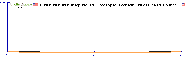
http://www.radsportfreaks.de/radsport/p ... kuapuaa01a
Type: ITT
Min-Tact: km1
Humuhumunukunukuapuaa 1b (Flat): Kona-Kona Ironman Cycling Course - 180km - 1180m elevation gain - 95min
The second half stage is a normal race on the Ironman Cycling Course. The 180km are flat wtihout sieb km and therefore a good opportunity for sprinters. However, an early escape might have good chances if teams are saving energy for the upcoming 42km TTT and two mountain stages. Another possibility is a puncheur attack on the last hill (+4 +3).
http://www.radsportfreaks.de/radsport/p ... kuapuaa01b
Type: Flat
Min-Tact: km170
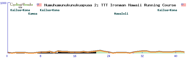
Humuhumunukunukuapuaa 2 (TTT): Kona-Kona Ironman Running Course - 42km - 290m elevation gain - 42min
The winner of the first RSF Ironman will be determined in the 42km TTT on the Running Course. Whoever receives the yellow jersey after this stage will go down into history! The TTT will however be a very tactical one. 42km requires good energy management and two mountain stages are following... the course itself is mainly flat, no relevant hills.
http://www.radsportfreaks.de/radsport/p ... ukuapuaa02
Type: TTT
Min-Tact: km1
Humuhumunukunukuapuaa 3 (HC): Kona - Mauna Kea - 207km - 6240m elevation gain - 133min
The beginning of the Humuhumunukunukuapuaa Tour is just brutal! After the Ironman comes an important mountain stage including 7km of gravel on the climb up to the Mauna Kea volcano with a long section with 10+% and with a final circuit around the observatory on the peak! The final 4km circuit is +5 +6 -6 -5. Everything is prepared for a showdown, if only riders have enough reg!
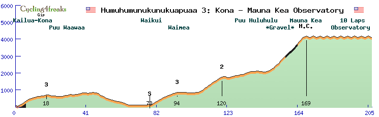
http://www.radsportfreaks.de/radsport/p ... ukuapuaa03
Type: Mountain
Min-Tact: km148
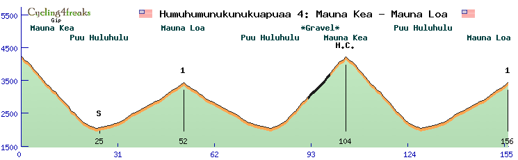
Humuhumunukunukuapuaa 4 (HC): Mauna Kea - Mauna Loa - 157km - 4850m elevation gain - 92min
Riders will welcome the downhill start of stage 4 after the Ironman and the first mountain stage, and also ahead of what's coming on this day's stage: The riders will ride down the Mauna Kea, up the Mauna Loa, back to the Mauna Kea and then once again to the summit finish on the Mauna Loa... a tough day. But what is the right moment for action? Do you attack early on the steep Mauna Kea with its gravel section and gradients up to 14%? Or later on the much easier Mauna Loa with a gradient of only 5-7%?
http://www.radsportfreaks.de/radsport/p ... ukuapuaa04
Type: Mountain
Min-Tact: km130
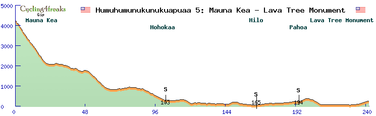
Humuhumunukunukuapuaa 5 (Flat): Mauna Kea - Hilo - 242km - 1450m elevation gain - 126min
After one Ironman and two mountain stages it is time to relax! What? He calls 242km relaxed? Yes! The first half is basically all downhill, so it allows riders to recharge. It looks a lot like a stage for an early escape but at the same time it could be a sprint stage, even if not so easy to control because of the length. The finish up to the Lava Tree Monument is a bit tricky in any case (for escapes and for sprinters) as it is all slightly uphill with 1-3%: 2 1 1 1 3 3 3 3 1 1
http://www.radsportfreaks.de/radsport/p ... ukuapuaa05
Type: Flat
Min-Tact: km232
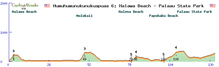
Humuhumunukunukuapuaa 6 (Hilly): Halawa Beach Park - Palaau State Park - 135km - 1260m elevation gain - 85min
Stage 6 is an short hilly stage over only 135km. Strong sprinter teams can probably create a mass sprint as the last sieb is 30km before the finish. But there are a few other sieb possibilities along the way and the other teams have a chance to make this a fast, merciless race for the sprinters.
http://www.radsportfreaks.de/radsport/p ... ukuapuaa06
Type: Hilly
Min-Tact: km100
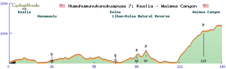
Humuhumunukunukuapuaa 7 (Hilly): Kealia - Waimea Canyon - 140km - 2460m elevation gain - 85min
The first week ends with a 140km short stage which has everything needed for action ahead of a rest day. There are a few hills and siebs on the way to the final section into and through the marvelous Weimea Canyon. Yes we ride through a Canyon! The climb into the Nature Park is tough but pretty irregular due to the landscape. The 17km climb has 6% on average but it has some steep sections up to 12% just like some flat sections of only 1-2%. After the climb, 12 flat-ish km follow: -1 1 0 3 2 -2 3 8 5 -1 1 -2. Lots of outcomes are possible with such a difficult, very hard to control finish.
http://www.radsportfreaks.de/radsport/p ... ukuapuaa07
Type: Hilly
Min-Tact: km110
************ REST DAY ************ REST DAY ************ REST DAY ************ REST DAY ************ REST DAY ************
Humuhumunukunukuapuaa 8 (Flat): Waikiki - Waikiki - 217km - 720m elevation gain - 113min
After a well deserved restday, the second week kicks off with an entirely flat stage. Sprinters say thanks. However, 217km is not the easiest to control and the last 10km provide some variety and opportunities to attack: 0 2 -2 2 -1 4 0 -2 -3 0
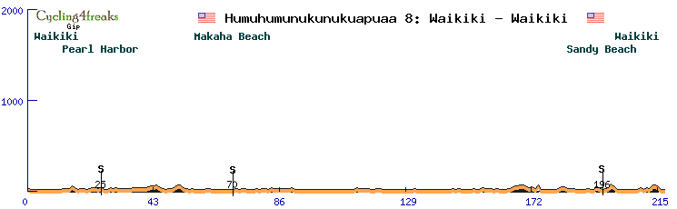
http://www.radsportfreaks.de/radsport/p ... ukuapuaa08
Type: Flat
Min-Tact: km208
Humuhumunukunukuapuaa 9 (Hilly): Mokapu Point - Mokapu Point - 137km - 2100m elevation gain - 84min
Stage 9 is a short hilly stage over the island of Honolulu. 4 hills should provide some action and make a mass sprint unlikely. Even if a strong sprint team is around, they will be discouraged by the +4% finish up to Mokapu point. So who will take the stage? A strong hill sprinter? A classic rider? Or an escape?
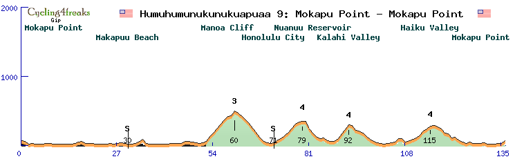
http://www.radsportfreaks.de/radsport/p ... ukuapuaa09
Type: Hilly
Min-Tact: km106
Humuhumunukunukuapuaa 10 (Hilly): La Perouse Bay - Kanaha Beach - 125km - 1230m elevation gain - 76min
Stage 10 is a short stage with only 125km and looks like a fight between sprinters and hill sprinters. There are three small hills on the way. The first one being 7 7 5, the second one 6 6 6 and the third one being 6 4, with only 19km afterwards towards the finish.
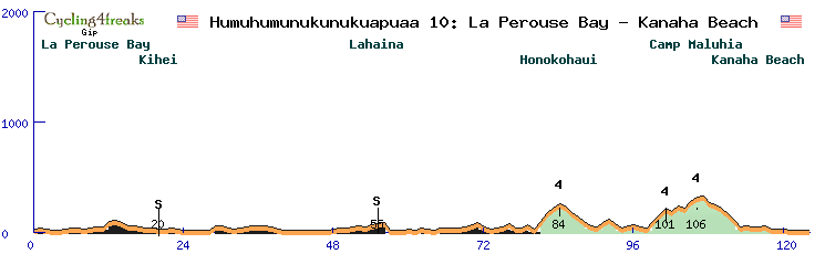
http://www.radsportfreaks.de/radsport/p ... ukuapuaa10
Type: Hilly
Min-Tact: km98
Humuhumunukunukuapuaa 11 (Hilly): Hana - Hana (Road to Hana) - 198km - 5430m elevation gain - 113min
The Road to Hana! What a highlight on stage 11! It is probably one of the most scenic and beautiful roads for cyclists. But it's not going to be that beautiful for the riders... 198 hilly kilometers ahead of a decisive mountain stage is tough. But in fact, riders will have more climbing on to do on this stage (5430m) than on the next day. With all the up and down in this stage, it could be the right stage to apply some pressure in GC, especially for riders with high reg. If nobody tries anything, could be a hill sprinter or classic win of course, or even an escape if nobody controls the race.
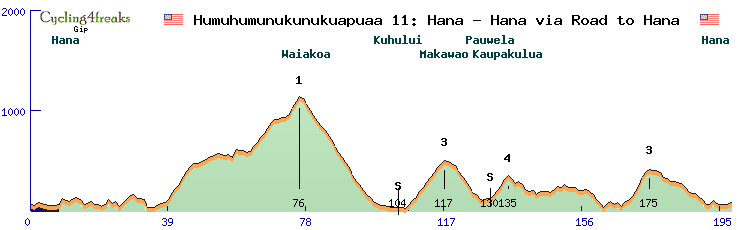
http://www.radsportfreaks.de/radsport/p ... ukuapuaa11
Type: Hilly
Min-Tact: km170
Humuhumunukunukuapuaa 12 (HC): Hana - Haleakala - 197km - 5290m elevation gain - 128min
Week 1 will have produced some significant gaps, but stage 12 might be the decisive stage. While the first week was nice for TT-specialists and required very strong teams for the mountains, the 40km climb up to the Haleakala volcano is more suited to pure climbers. Not too steep, but a lot of it is 6-8%. Here they can gain time back that they might have lost in the first week. Form settings can also play a role. Do you put it early for the TTT and the first two mountain stages? Or do you save the form for the decisive stage?
http://www.radsportfreaks.de/radsport/p ... ukuapuaa12
Type: Mountain
Min-Tact: km138
Humuhumunukunukuapuaa 13 (Flat): Haleakala - Haiku Pauwela - 105km - 400m elevation gain - 82min
The last stage is for the downhill experts. We simply go down the Haleakala volcano and then the peloton will do 5 laps on a 10km circuit in Haiku Pauwela. The circuit is not too easy though: 1 -4 -4 -2 0 -1 2 3 2 3
http://www.radsportfreaks.de/radsport/p ... ukuapuaa13
Type: Flat
Min-Tact: km86
GIP MASTERPLAN
Gameplay: Flexible Min-Tact. Improve Sprint System. Windkante.
Marketing: Re-attract old players. Advertisement. Social Media.
New Players: Fair Start Budget, New Tutorial.
Fairplay: Improve FPC features, Fair Prize Money Disribution.
Gameplay: Flexible Min-Tact. Improve Sprint System. Windkante.
Marketing: Re-attract old players. Advertisement. Social Media.
New Players: Fair Start Budget, New Tutorial.
Fairplay: Improve FPC features, Fair Prize Money Disribution.

Re: December Tour 2020: Presentation
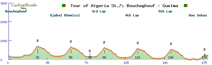
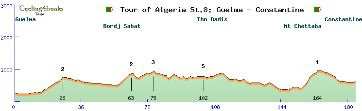
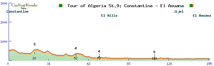
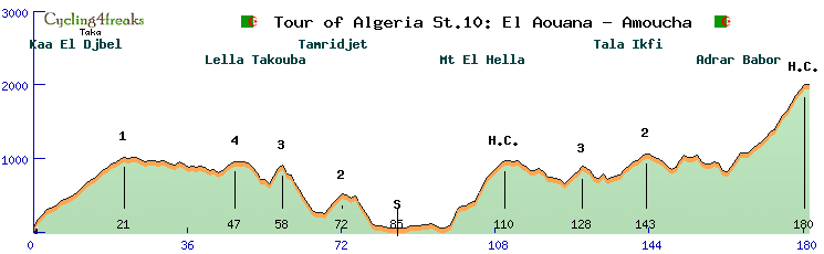
Tour of Algeria
Stage1: ITT 19KM
Last20 km: / 3 3 4 -1 -3 2 4 2 -1 1 1 0 0 10 8 7 7 8 8
http://www.radsportfreaks.de/radsport/p ... ension=c4f
Stage2: Flat 175KM
Categorized Climbs:
http://www.radsportfreaks.de/radsport/p ... ension=c4f
Stage3: Middle Mountain 165KM
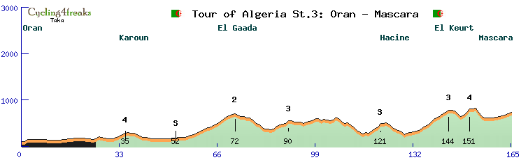
Categorized Climbs:
http://www.radsportfreaks.de/radsport/p ... ension=c4f
Stage4: Middle Mountain 163KM
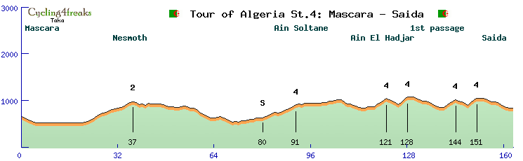
Categorized Climbs:
http://www.radsportfreaks.de/radsport/p ... ension=c4f
Stage5: Flat 172KM
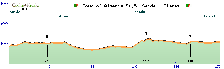
Categorized Climbs:
http://www.radsportfreaks.de/radsport/p ... ension=c4f
Stage6: High Mountain 207KM
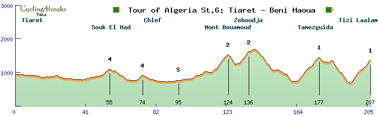
Categorized Climbs:
http://www.radsportfreaks.de/radsport/p ... ension=c4f
- - - - - - - - - - Rest Day - - - - - - - - - -
Stage7: Middle Mountain 179KM
Categorized Climbs:
http://www.radsportfreaks.de/radsport/p ... ension=c4f
Stage8: Middle Mountain 184KM
Categorized Climbs:
http://www.radsportfreaks.de/radsport/p ... ension=c4f
Stage9: Flat 156KM
Categorized Climbs:
http://www.radsportfreaks.de/radsport/p ... ension=c4f
Stage10: High Mountain 181KM
Categorized Climbs:
http://www.radsportfreaks.de/radsport/p ... ension=c4f
Stage11: High Mountain 180KM
Categorized Climbs:
http://www.radsportfreaks.de/radsport/p ... ension=c4f
Stage12: Flat 165KM
Categorized Climbs:
http://www.radsportfreaks.de/radsport/p ... ension=c4f
Stage12: ITT 19KM
Last20 km: / 0 0 0 0 0 0 0 0 0 0 0 0 1 1 -1 -2 1 0 0
http://www.radsportfreaks.de/radsport/p ... ension=c4f
Stage1: ITT 19KM
Last20 km: / 3 3 4 -1 -3 2 4 2 -1 1 1 0 0 10 8 7 7 8 8
http://www.radsportfreaks.de/radsport/p ... ension=c4f
Stage2: Flat 175KM
Categorized Climbs:
- Cat4 Km12: 2 3 3 3
- Cat4 Km37: 7 5 4
- Cat4 Km73: 4 5 3 4
- Cat4 Km 156: 6
http://www.radsportfreaks.de/radsport/p ... ension=c4f
Stage3: Middle Mountain 165KM
Categorized Climbs:
- Cat4 Km35: 2 3 4 3
- Cat2 Km72: 3 2 2 4 3 4 1 2 4 4 4 4 5 3 3 2
- Cat3 Km90: 6 2 2 1 6
- Cat3 Km121: 5 4 5 7
- Cat3 Km144: 5 5 3 6 5 4 4 4 4 4
- Cat4 Km151: 7 7
http://www.radsportfreaks.de/radsport/p ... ension=c4f
Stage4: Middle Mountain 163KM
Categorized Climbs:
- Cat2 Km37: 2 3 4 5 3 3 2 3 2 2 2 1 3 5 2 2
- Cat4 Km91: 3 4 3 3 4
- Cat4 Km121: 5 4 4 4
- Cat4 Km128: 6 6 4
- Cat4 Km144: 5 4 4 4
- Cat4 Km151: 6 6 4
http://www.radsportfreaks.de/radsport/p ... ension=c4f
Stage5: Flat 172KM
Categorized Climbs:
- Cat3 Km112: 3 5 5 4 2 5 5 5 0 -4 5 5
http://www.radsportfreaks.de/radsport/p ... ension=c4f
Stage6: High Mountain 207KM
Categorized Climbs:
- Cat4 Km55: 3 4 5 4 3
- Cat4 Km74: 4 6 4
- Cat2 Km124: 9 5 8 7 7 4 3
- Cat2 Km136: 2 9 5 7 7 6
- Cat1 Km177: 4 7 6 8 6 6 4 3 3 10 6 7 3
- Cat1 Km207: 9 8 8 7 5 3 4 5 6 8 5
http://www.radsportfreaks.de/radsport/p ... ension=c4f
- - - - - - - - - - Rest Day - - - - - - - - - -
Stage7: Middle Mountain 179KM
Categorized Climbs:
- Cat2 of the circuit: 3 7 6 8 6 11 4
- Cat3 Km176: 6 6 4 6
http://www.radsportfreaks.de/radsport/p ... ension=c4f
Stage8: Middle Mountain 184KM
Categorized Climbs:
- Cat2 Km26: 3 6 2 4 3 4 4 4 2 4 5 7
- Cat Km63: 5 6 6 6 6 2 3
- Cat3 Km75: 5 3 3 3 3 -2 3 6
- Cat1 Km164: 6 5 8 10 7 6 4 3 7
http://www.radsportfreaks.de/radsport/p ... ension=c4f
Stage9: Flat 156KM
Categorized Climbs:
- Cat3 Km20: 6 7 5
- Cat4 Km52: 4 4 5
- Cat4 Km70: 7
http://www.radsportfreaks.de/radsport/p ... ension=c4f
Stage10: High Mountain 181KM
Categorized Climbs:
- Cat1 Km21: 8 7 7 2 3 6 3 1 3 5 5 6 5 3 6 5 2 7 1 4 3
- Cat4 Km47: 3 7 2 4
- Cat3 Km58: 10 10 5
- Cat2 Km72: 7 8 6 6
- HC Km110: 4 10 12 5 -1 5 2 13 10 10 6 6 5 5
- Cat3 Km128: 5 7 4 8
- Cat2 Km143: 8 5 5 2 6 3
- HC Km180: 8 8 9 0 1 5 5 5 6 7 3 9 10 7 10 10 8 8
http://www.radsportfreaks.de/radsport/p ... ension=c4f
Stage11: High Mountain 180KM
Categorized Climbs:
- HC Km92: 3 7 4 9 7 8 7 9 6 6 6 5 11 5 3 6 7 -2 3
- Cat1 Km133: 7 2 10 7 10 6 8 7 6 7 9 1 2 3 2 -5 5
- HC Km168: 4 4 9 7 9 7 9 8 5 6 8 8 5 3 5 8 -2 4 1
http://www.radsportfreaks.de/radsport/p ... ension=c4f
Stage12: Flat 165KM
Categorized Climbs:
- Cat1 Km23: 4 3 4 4 7 11 6 2 8 6 5 3 1
http://www.radsportfreaks.de/radsport/p ... ension=c4f
Stage12: ITT 19KM
Last20 km: / 0 0 0 0 0 0 0 0 0 0 0 0 1 1 -1 -2 1 0 0
http://www.radsportfreaks.de/radsport/p ... ension=c4f
Re: December Tour 2020: Presentation
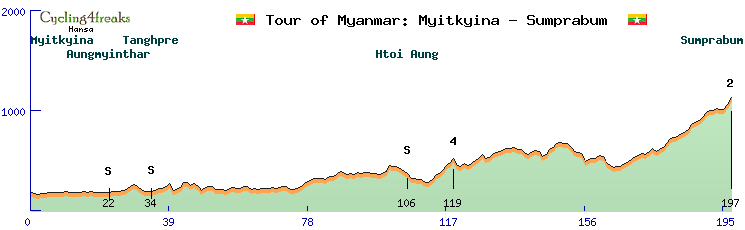
Tour of Myanmar 
We will ride 2 weeks the Republic of the Union of Myanmar.
14 Days with rest Day at Day 8. Half stage at the First Day with the Prologue and a Flat Stage.
Therefore 14 days, 13 days of riding and 1 day of half stages.
The tour will have 2 ITT, 1 TTT, 5 Flat stages, 4 Middle Mountain stage and 2 High Mountain Stages
All the roads will be in perfect conditions because they really want C4F to ride the December tour thert and they promised to give us perfect Roads if we decide to ride here.
Every Stage (except time tirals) will have 3 IS they normally are placed in a city or village, sometimes they are placed at some special places like an Restaurant or a motorcycle workshop.
The Tour hopefully will be pretty open till the last stage.
It will be an hard tour to control even so it is a 9 rider tour, but many of the stages are very long with 5 stages of 200+ kms and only 1 stage (except for the time trials) with less than 180 kms to ride.
Prologue(Half Stage)(3km, 3 min): 3 kms short and sweet. a time trialist will take the yellow here.
http://www.radsportfreaks.de/radsport/p ... ension=c4f
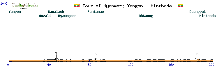
Stage 1(Half Stage)(202 kms, min tact km 190, 107 min): Long and Flat stage with 3 IS the sprinter should be able to do it here if they cooperate. Otherwise maybe a group can beat them.
Yellow could stay on the Prologes winners shoulders but maybe with all these time bonification it will change during the first couple stage.
Last 20 kms: 0 0 0 0 2 -1 0 -1 1 0 0 0 0 -1 0 0 0 1 0 0
http://www.radsportfreaks.de/radsport/p ... ension=c4f
Stage 2 (212 km, min tact km 200, 112 min): Another Long and Flat stage. Same as on Stage 1 Sprinters can do it if they cooperate.
Last 20 kms: -2 4 1 -3 0 -1 0 0 2 1 0 0 1 0 -1 -1 -1 0 1 -1
http://www.radsportfreaks.de/radsport/p ... ension=c4f
Stage 3 (193 km, min tact km 166, 110 min): A bit less Flat today but again no sieb kms should be easy for the Sprinters but once more very long if they dont cooperate it could be hard to do it 3 stages in a row. Also the first mountain points can be grabbed here.
Last 20 kms: 2 0 1 0 -1 -1 -1 -1 -1 -2 -1 -2 1 0 0 -1 -2 -1 -2 1
Kat4: 1 2 1 1 1 1 1 0 2 1 2 1 -1 2
Kat4: 1 2 3 2 1 2 1 2 2 0 1
http://www.radsportfreaks.de/radsport/p ... ension=c4f
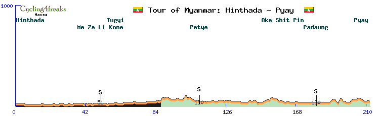
Stage 4 (164 km, min tact 140, 94 min) : Middle Mountain Stage here. f the Yellow didnt change before it most likely will today. Not the hardest hills and also not many sieb kms but pretty long mountains here. Not sure who will win here maybe a climber can do it or a strong classic. Profile looks perfekt for 80-70s but it will be an open finish.
Last 20 kms: 0 0 1 1 1 4 4 1 1 2 7 5 2 5 6 5 2 2 2 3
Kat 2: 2 1 2 2 4 4 5 4 6 2 4 5 5 4 3 5 4 5 4 2 4 3 0 2 2 4 3 4 4
Kat 4: 2 3 2 4
Kat 4: 1 4 9
KAt 2: 1 1 1 4 4 1 1 2 7 5 2 5 6 5 2 2 2 3
http://www.radsportfreaks.de/radsport/p ... ension=c4f
Stage 5 (40 km, 40 min): Team Time Trial today. Its sligthly hilly but not to hard. Could be Interesting for the classement already because of the lengths it will be pretty interesting how the teams calculate4 with their power. Also is pretty likely to change here once more.
Last 20 kms:2 3 3 1 2 2 1 5 6 3 3 1 2 1 -1 0 1 -3 -2 0
Kat 4: 1 2 3 3 1 2 2 1 5 6 3 3 1 2 1
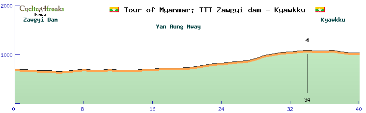
http://www.radsportfreaks.de/radsport/p ... ension=c4f
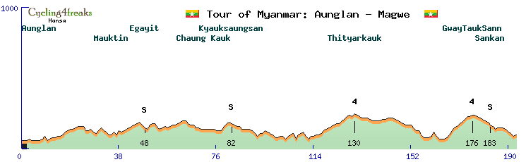
Stage 6 (180km, min tact km 150, 105 min): Middle Mountain. Its the first harder stage with some longer and steeper mountains. The finish once more will be interesting between climbers and Classics. Also some time for the gc fight can be gained here.
Last 20 kms: 4 -1 2 3 7 8 10 1 -7 2 1 3 5 3 6 1 -4 1 5 -2
Kat 4: 1 1 2 3 3 4 1 2 -0 1 2 2 2 0 2 1 1 1 4 5 1 1 2
Kat 2: 5 5 5 4 6 5 4 1 2 5 9 6 2 3 -1 4 3 1 2 2
Kat 3: 4 9 3 3
Kat 3: 2 3 5 9 1 0 4 3
Kat 2: 2 3 7 8 10
Kat 3: 2 1 3 5 3 6
http://www.radsportfreaks.de/radsport/p ... ension=c4f
Stage 7 (215km, min tact km 200, 115 min): After some harder Days we will finish the first week with another long flat Stage. Another day for the sprinter if they have their teams fit.
Last 20 kms: 0 0 0 -1 0 0 0 0 1 0 0 0 0 0 0 0 0 0 0 0
http://www.radsportfreaks.de/radsport/p ... ension=c4f
__________________________________________________________________________________________________________________
RESTDAY: The riders may need the restday to prepare for the 2nd and much harder week of the Tour of Myanmar. Also we will move from Mandalay to Kyaukhtu on this day.
__________________________________________________________________________________________________________________
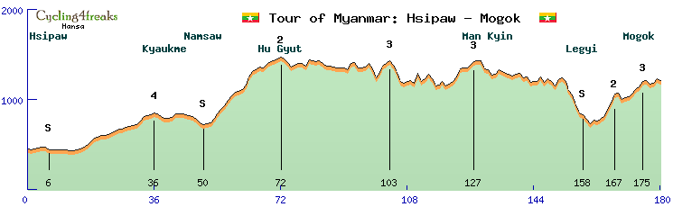
Stage 8 (200km, mintact km 132, 134 min): After the Rest day we will face another middle mountain stage but one much harder than the middle mountain stages in week 1.
The first really hard and long climbs will wait here for our riders.
Last 20 kms: 5 8 5 10 5 1 -4 -4 -2 5 5 2 5 4 0 2 -1 -6 3 -2
Kat 1: 5 3 3 7 7 5 6 6 6 8 8 8 7 5 8 4
Kat HC: 1 2 1 4 6 6 6 6 3 7 4 7 7 5 6 8 6 5 4 4 6 6 1 2 1
Kat 4: 7 2 6 6
Kat 4: 2 3 3 5
Kat 4: 4 6 5 4
Kat 4: 7 7 4
Kat 1: 7 3 6 6 8 7 9 5 3 6
Kat 1: 2 7 5 5 8 5 10 5
Kat 4: 5 5 2 5 4
http://www.radsportfreaks.de/radsport/p ... ension=c4f
Stage 9 (25km, min tact km 1, 25 minutes): Mountain individual time trial. Stage 9 will be very important for classement. A 25 km pretty hard ITT. even power could play a role here because of hard stages before and after.
Last 25 kms: 2 0 4 7 -3 -4 -5 -7 -0 -1 -1 4 -5 -9 -3 6 5 6 5 7 6 7 4 5 2
Kat 2: 6 5 6 5 7 6 7 4 5 2
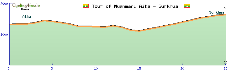
http://www.radsportfreaks.de/radsport/p ... ension=c4f
Stage 10 (185 km, min tact km 130, 120 min): Mountain top finish. Very hard and Long Mountain top finish. The classement fight should really go on here. After the ITT the stage before some low reg classement riders could face big problems here.
Last 20 kms: 9 6 4 7 7 6 4 3 6 3 -4 0 -2 -0 0 1 2 9 9 6
Kat 1: 3 5 6 4 7 4 7 4 2 5 4 3 3 5 2 7 7 4 5 7 5 5 6 5 5
Kat HC: 4 1 0 8 2 7 8 8 9 6 4 7 7 6 4 3 6 3
Kat 2: 1 2 9 9 6
http://www.radsportfreaks.de/radsport/p ... ension=c4f
Stage 11 ( 192 km, min tact km 178, 103 min): Another Mountain top finish to fight for the classement. After already 10 mostly long stages it will be interesting which teams still will be fit to fight here.
Last 20 kms: -1 1 1 1 0 0 7 12 10 4 8 3 5 12 4 9 13 6 -1 7
Kat 3: 10 6 5
Kat 1: 4 2 8 9 8 8 6 8 7 8
Kat HC: 7 12 10 4 8 3 5 12 4 9 13 6 -1 7
http://www.radsportfreaks.de/radsport/p ... ension=c4f
Stage 12 (225 km, min tact km 220, 115 min): Flat stage. The longest stage of the tour but totally Flat. maybe some teams can rest here after the classement fight but still the classement leader possibly has to control here if a dangerous group escapes here. Also sprinters have a last chance to fight for the sprinter jersey.
Last 20 kms: 2 -1 -1 -1 -2 -1 0 1 0 0 -1 0 3 -2 -2 0 1 -1 0 0
Kat 4: 7
http://www.radsportfreaks.de/radsport/p ... ension=c4f
Stage 13 (197 km, min tact km 160, 117 min): Middle Mountain Stage. the tour of Myanmar will finish the tour on a 197km middle mountain stage. it is possible to attack the classement here one last time even tho it is not to hard to control it here.
Last 20 kms: 2 5 4 1 1 3 1 3 5 2 2 3 5 2 0 2 -1 0 5 7
Kat 4: 3 5 1 4 4 3 4
Kat 2: 3 1 3 3 1 2 -1 3 3 -3 2 2 5 4 1 1 3 1 3 5 2 2 3 5 2 0 2 -1 0 5 7
http://www.radsportfreaks.de/radsport/p ... ension=c4f
We will ride 2 weeks the Republic of the Union of Myanmar.
14 Days with rest Day at Day 8. Half stage at the First Day with the Prologue and a Flat Stage.
Therefore 14 days, 13 days of riding and 1 day of half stages.
The tour will have 2 ITT, 1 TTT, 5 Flat stages, 4 Middle Mountain stage and 2 High Mountain Stages
All the roads will be in perfect conditions because they really want C4F to ride the December tour thert and they promised to give us perfect Roads if we decide to ride here.
Every Stage (except time tirals) will have 3 IS they normally are placed in a city or village, sometimes they are placed at some special places like an Restaurant or a motorcycle workshop.
The Tour hopefully will be pretty open till the last stage.
It will be an hard tour to control even so it is a 9 rider tour, but many of the stages are very long with 5 stages of 200+ kms and only 1 stage (except for the time trials) with less than 180 kms to ride.
Prologue(Half Stage)(3km, 3 min): 3 kms short and sweet. a time trialist will take the yellow here.
http://www.radsportfreaks.de/radsport/p ... ension=c4f
Stage 1(Half Stage)(202 kms, min tact km 190, 107 min): Long and Flat stage with 3 IS the sprinter should be able to do it here if they cooperate. Otherwise maybe a group can beat them.
Yellow could stay on the Prologes winners shoulders but maybe with all these time bonification it will change during the first couple stage.
Last 20 kms: 0 0 0 0 2 -1 0 -1 1 0 0 0 0 -1 0 0 0 1 0 0
http://www.radsportfreaks.de/radsport/p ... ension=c4f
Stage 2 (212 km, min tact km 200, 112 min): Another Long and Flat stage. Same as on Stage 1 Sprinters can do it if they cooperate.
Last 20 kms: -2 4 1 -3 0 -1 0 0 2 1 0 0 1 0 -1 -1 -1 0 1 -1
http://www.radsportfreaks.de/radsport/p ... ension=c4f
Stage 3 (193 km, min tact km 166, 110 min): A bit less Flat today but again no sieb kms should be easy for the Sprinters but once more very long if they dont cooperate it could be hard to do it 3 stages in a row. Also the first mountain points can be grabbed here.
Last 20 kms: 2 0 1 0 -1 -1 -1 -1 -1 -2 -1 -2 1 0 0 -1 -2 -1 -2 1
Kat4: 1 2 1 1 1 1 1 0 2 1 2 1 -1 2
Kat4: 1 2 3 2 1 2 1 2 2 0 1
http://www.radsportfreaks.de/radsport/p ... ension=c4f
Stage 4 (164 km, min tact 140, 94 min) : Middle Mountain Stage here. f the Yellow didnt change before it most likely will today. Not the hardest hills and also not many sieb kms but pretty long mountains here. Not sure who will win here maybe a climber can do it or a strong classic. Profile looks perfekt for 80-70s but it will be an open finish.
Last 20 kms: 0 0 1 1 1 4 4 1 1 2 7 5 2 5 6 5 2 2 2 3
Kat 2: 2 1 2 2 4 4 5 4 6 2 4 5 5 4 3 5 4 5 4 2 4 3 0 2 2 4 3 4 4
Kat 4: 2 3 2 4
Kat 4: 1 4 9
KAt 2: 1 1 1 4 4 1 1 2 7 5 2 5 6 5 2 2 2 3
http://www.radsportfreaks.de/radsport/p ... ension=c4f
Stage 5 (40 km, 40 min): Team Time Trial today. Its sligthly hilly but not to hard. Could be Interesting for the classement already because of the lengths it will be pretty interesting how the teams calculate4 with their power. Also is pretty likely to change here once more.
Last 20 kms:2 3 3 1 2 2 1 5 6 3 3 1 2 1 -1 0 1 -3 -2 0
Kat 4: 1 2 3 3 1 2 2 1 5 6 3 3 1 2 1
http://www.radsportfreaks.de/radsport/p ... ension=c4f
Stage 6 (180km, min tact km 150, 105 min): Middle Mountain. Its the first harder stage with some longer and steeper mountains. The finish once more will be interesting between climbers and Classics. Also some time for the gc fight can be gained here.
Last 20 kms: 4 -1 2 3 7 8 10 1 -7 2 1 3 5 3 6 1 -4 1 5 -2
Kat 4: 1 1 2 3 3 4 1 2 -0 1 2 2 2 0 2 1 1 1 4 5 1 1 2
Kat 2: 5 5 5 4 6 5 4 1 2 5 9 6 2 3 -1 4 3 1 2 2
Kat 3: 4 9 3 3
Kat 3: 2 3 5 9 1 0 4 3
Kat 2: 2 3 7 8 10
Kat 3: 2 1 3 5 3 6
http://www.radsportfreaks.de/radsport/p ... ension=c4f
Stage 7 (215km, min tact km 200, 115 min): After some harder Days we will finish the first week with another long flat Stage. Another day for the sprinter if they have their teams fit.
Last 20 kms: 0 0 0 -1 0 0 0 0 1 0 0 0 0 0 0 0 0 0 0 0
http://www.radsportfreaks.de/radsport/p ... ension=c4f
__________________________________________________________________________________________________________________
RESTDAY: The riders may need the restday to prepare for the 2nd and much harder week of the Tour of Myanmar. Also we will move from Mandalay to Kyaukhtu on this day.
__________________________________________________________________________________________________________________
Stage 8 (200km, mintact km 132, 134 min): After the Rest day we will face another middle mountain stage but one much harder than the middle mountain stages in week 1.
The first really hard and long climbs will wait here for our riders.
Last 20 kms: 5 8 5 10 5 1 -4 -4 -2 5 5 2 5 4 0 2 -1 -6 3 -2
Kat 1: 5 3 3 7 7 5 6 6 6 8 8 8 7 5 8 4
Kat HC: 1 2 1 4 6 6 6 6 3 7 4 7 7 5 6 8 6 5 4 4 6 6 1 2 1
Kat 4: 7 2 6 6
Kat 4: 2 3 3 5
Kat 4: 4 6 5 4
Kat 4: 7 7 4
Kat 1: 7 3 6 6 8 7 9 5 3 6
Kat 1: 2 7 5 5 8 5 10 5
Kat 4: 5 5 2 5 4
http://www.radsportfreaks.de/radsport/p ... ension=c4f
Stage 9 (25km, min tact km 1, 25 minutes): Mountain individual time trial. Stage 9 will be very important for classement. A 25 km pretty hard ITT. even power could play a role here because of hard stages before and after.
Last 25 kms: 2 0 4 7 -3 -4 -5 -7 -0 -1 -1 4 -5 -9 -3 6 5 6 5 7 6 7 4 5 2
Kat 2: 6 5 6 5 7 6 7 4 5 2
http://www.radsportfreaks.de/radsport/p ... ension=c4f
Stage 10 (185 km, min tact km 130, 120 min): Mountain top finish. Very hard and Long Mountain top finish. The classement fight should really go on here. After the ITT the stage before some low reg classement riders could face big problems here.
Last 20 kms: 9 6 4 7 7 6 4 3 6 3 -4 0 -2 -0 0 1 2 9 9 6
Kat 1: 3 5 6 4 7 4 7 4 2 5 4 3 3 5 2 7 7 4 5 7 5 5 6 5 5
Kat HC: 4 1 0 8 2 7 8 8 9 6 4 7 7 6 4 3 6 3
Kat 2: 1 2 9 9 6
http://www.radsportfreaks.de/radsport/p ... ension=c4f
Stage 11 ( 192 km, min tact km 178, 103 min): Another Mountain top finish to fight for the classement. After already 10 mostly long stages it will be interesting which teams still will be fit to fight here.
Last 20 kms: -1 1 1 1 0 0 7 12 10 4 8 3 5 12 4 9 13 6 -1 7
Kat 3: 10 6 5
Kat 1: 4 2 8 9 8 8 6 8 7 8
Kat HC: 7 12 10 4 8 3 5 12 4 9 13 6 -1 7
http://www.radsportfreaks.de/radsport/p ... ension=c4f
Stage 12 (225 km, min tact km 220, 115 min): Flat stage. The longest stage of the tour but totally Flat. maybe some teams can rest here after the classement fight but still the classement leader possibly has to control here if a dangerous group escapes here. Also sprinters have a last chance to fight for the sprinter jersey.
Last 20 kms: 2 -1 -1 -1 -2 -1 0 1 0 0 -1 0 3 -2 -2 0 1 -1 0 0
Kat 4: 7
http://www.radsportfreaks.de/radsport/p ... ension=c4f
Stage 13 (197 km, min tact km 160, 117 min): Middle Mountain Stage. the tour of Myanmar will finish the tour on a 197km middle mountain stage. it is possible to attack the classement here one last time even tho it is not to hard to control it here.
Last 20 kms: 2 5 4 1 1 3 1 3 5 2 2 3 5 2 0 2 -1 0 5 7
Kat 4: 3 5 1 4 4 3 4
Kat 2: 3 1 3 3 1 2 -1 3 3 -3 2 2 5 4 1 1 3 1 3 5 2 2 3 5 2 0 2 -1 0 5 7
http://www.radsportfreaks.de/radsport/p ... ension=c4f
Hansa
est. 03.08.2009
est. 03.08.2009
-
el Galactico
- Posts: 908
- Joined: Wed Feb 17, 2010 5:12 pm
- Contact:
Re: December Tour 2020: Presentation
 TOUR OF SRI LANKA
 How about spending 2 weeks of December on the beautiful island of Sri Lanka, formerly known as Ceylon?
Here is the route the race committee put together to convince the C4F-world to travel to Sri Lanka:
A total of 2004 km
- 1 TTT
- 1 TT
- 4 Flat stages
- 4 Middle mountain stages
- 3 HC mountain stages
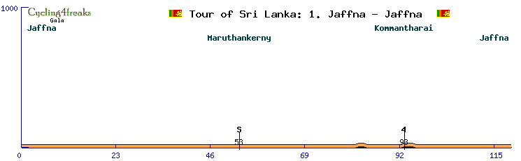
Stage 1: Jaffna - Jaffna
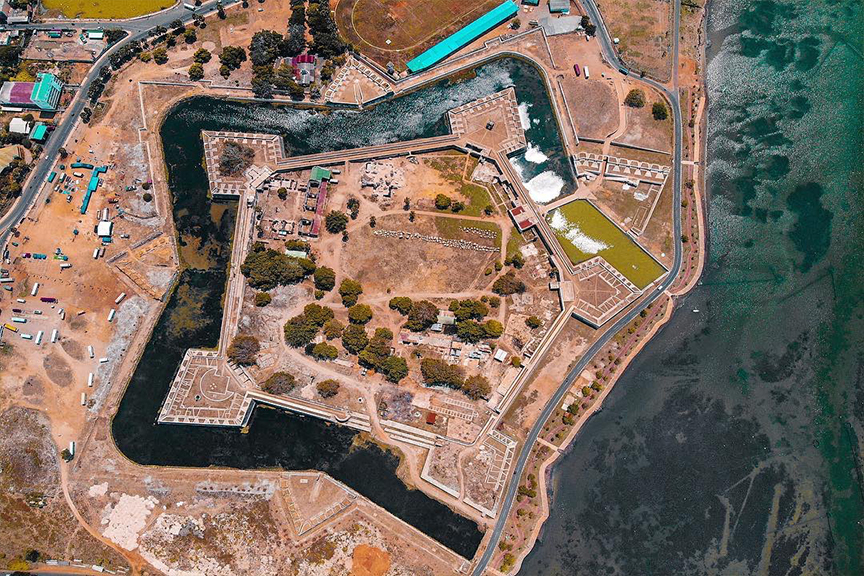
The start of this tour will be held in the northernmost city of the island - Jaffna. The city was once the second largest on the island but suffered heavily during the civil war when it was occupied by the rebel army of the "Tamil Tigers".
The start & finish line will be right in front of Jaffna fort, which was built 1618 by the Portuguese invaders.
It is completely flat course of 119 km. The winner of this stage will also wear the first yellow jersey of this tour.
Min tact: km 98
Cat. 4 (km 93): 1
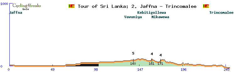
Stage 2: Jaffna - Trincomalee
The second stage is again nearly completely flat. Just that this time the teams have to cover a total of 249 kms from Jaffna to Trincomalee on the east coast of the island. Of course the longest stage of this tour.
Min tact: km 238
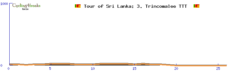
Stage 3: TTT Trincomalee
We stay in the beach town of Trincomalee for a team time trial of 26 km. Can one of the sprinter's keep yellow or will it already change to one of the strong GC teams?
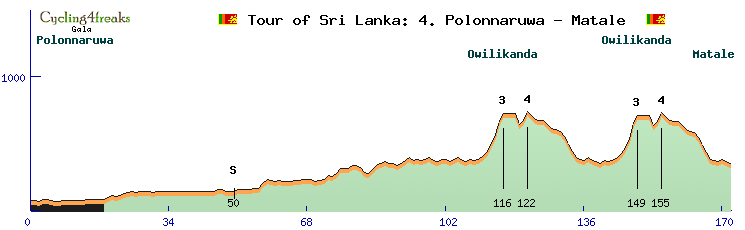
Stage 4: Polonnaruwa - Matale
The first mountains are waiting. The first 100 km after the start in Polonnaruwa are still flat but after arriving in Matale the peloton has to do 2 rounds up to Owilikanda.
Min tact: km 142
Owilikanda (2x): 7 km @ 5 % / max. 12 %
Cat 4 climb: 2 km @ 5 % / max. 7 %
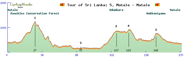
Stage 5: Matale - Matale
Stage 5 leads the peloton around and through the Knuckles Forest Reserve. Start and finish are in Matale. It is a hilly course with 4 categorized climbs.
From the last hill (3 km @ 8,7 %) it is 25 kms until the finish line.
Min tact: km 140
Knuckles Conservation Forest (Cat. 1): 14 km @ 5,8 % / max. 12%
Udumbara (Cat. 2): 16 km @ 4,4 % / max. 9 %
Cat. 4: 2 km @ 5,5 % / max. 6 %
Makkanigama (cat. 3): 3 km @ 8,7 % / max. 11 %
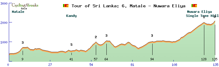
Stage 6: Matale - Nuwara Eliya
Stage 6 will bring us for the first time deep into the Sri Lankan Highlands. The peloton will pass through endless tea fields and dense green jungle before arriving in Nuwara Eliya - a city that makes you feel as if you were somewhere in Great Britain.
The climb to Nuwara Eliya is long but never very steep and never surpases 8 %. After passing through the city the riders will have to tackle the short climb to Single Tree Hill with a steep last km of 10%.
Min tact: km 104
Climb to Nuwara Eliya (Cat. 1): 19 km @ 5,3 % / max. 8 %
Single Tree Hill (Cat. 3): 3 km @ 6 % / max. 10 %
Last 10 km: 5 6 5 -6 -3 -1 -1 2 6 10
-------!!! REST DAY !!!--------
Stage 7: Nuwara Eliya - Tangalle
After the rest day everybody should be well rested and will probably have tested one of the famous Ceylon teas which are harvested all around this area of Sri Lanka.
The stage leads the riders out of the Highlands again and onto the southern beaches of the island. The finish will be directly by the ocean in the city of Tangalle - which besides the beaches is also known for great opportunities to see whales and dolphins out in the ocean.
The stage has just one categorized mountain which will be reached on km 46 - 130 km from the finish line. The sprinter teams will be fit so it should be a stage for the them.
Min tact: km 156
Cat. 3: 6 km @ 6,7 % / max. 11 %
Stage 8: Tangalle - Galle - Tangalle
For stage 8 we stick to the beaches for the first part of the stage. At km 80 the peloton will pass through the city of Galle with its big fort - again built by the Portuguese conquerors. After passing these 2 kms of cobble stones (**) we will turn inland and take another way back to Tangalle.
With the one and only sieb km 55 km away from the finish line it looks once again like an easy day for the sprinters.
Min tact: km 152
Henegama (Cat. 4): 2 km @ 4% / max. 6%
Stage 9: Tangalle - Balangoda
After 2 days at the beaches it is time again to head inland towards the Sri Lankan Highlands for a furious finish of this tour. The stage from Tangalle to Balangoda should be one for the strong classic riders. It is also one of the longer stages with 216 kms. There are 4 categorized climbs along the way (3x Cat. 2 + 1x Cat. 3). The last hill ends 15 kms before the finish line.
Min tact: km 188
Cat. 2 (km 69): 11 km @ 4,9% / max. 10%
Cat. 2 (km 89): 7 km @ 6,3% / max. 9%
Cat. 3 (km 143): 2 km @ 7% / max. 10% -> this hill is actually a short gravel section (*)
Cat. 2 (km 201): 7 km @ 5,7% / max. 9 %
Last 10 km: 0 3 3 1 -1 -2 -1 -1 -1 0
Stage 10: Balangoda - Bandarawela
Stage 10 is the second HC mountain stage of this tour though it is not a clear shot for the climbers at all. After reaching the little town of Ella on km 144 there is a short downhill section and then the final kms up to Bandarawela might not be steep enough for the climber's to create a big enough gap to overcome the last flat km.
Min tact: km 124
Climb to Haputhale (Cat.1): 27 km @ 3,9 % / max. 10%
Dulgolla (Cat.3): 7 km @ 3,6 % / max. 6%
Climb to Ella (cat. 1): 7 km @ 6% / max. 11%
Last 10 km: -2 -4 -1 4 3 5 5 4 5 0
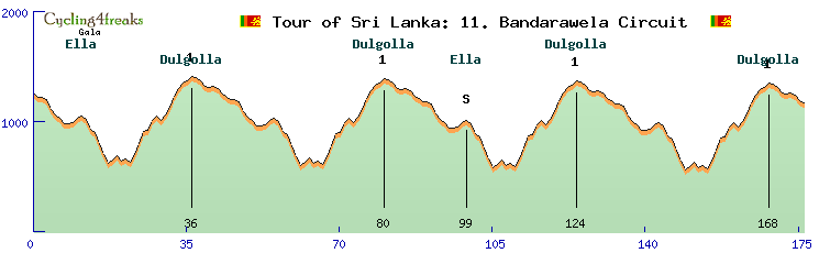
Stage 11: Bandarawela Circuit
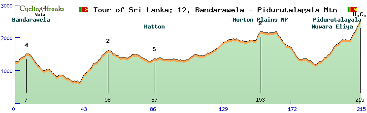
Stage 12: Bandarawela - Pidurutalagala Mountain
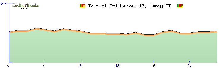
Stage 13: TT Kandy
Last edited by el Galactico on Fri Oct 30, 2020 12:57 pm, edited 2 times in total.
Rodrigo Tellez - Winner of Tour Down Under 2023!!!
Siempre Campeones! Hala Galacticos!!
Statistics
Hall of Fame
Cyclist of the Month
Siempre Campeones! Hala Galacticos!!
Statistics
Hall of Fame
Cyclist of the Month
-
Pokemon Club

- Posts: 3185
- Joined: Mon Oct 17, 2011 1:37 pm
- Contact:
Re: December Tour 2020: Presentation
Mediterranean Islands Tour, by Olmania & Pokemon Cycling Organization
First collaboration of the history between OL & Pokemon, Mediterranean Islands Tour (MIT), which visit 9 differents countries, is a tour that offers opportunities for various kinds of riders. Actually, almost all kinds of riders. And the GC fight might not be (only) a climber's affair. Why so ? Because 2020 was already a dream year for climbers with plenty of GC, stages and jerseys to win. More than the past years. So, MIT gives a chance for other kinds of leaders to compete for a long tour win !
Having dirt roads and pavés sections is something that might give a challenge for climbers; and having 1 ITT and 1 TTT is also challenging for GC competition.
Many stages are open, which means that the favorites of the stage will depend on the scenarii and the line-up of each tour. Many stages could be nervous, with fears of GC moves in various parts of stages, especially if the GC contenders are not only climbers and can be offensive on flatish/hilly stages.
Sprinters will have their word to say of course. Sprint stages are not all that easy, but some hilly stages could end up in a MS in case no one decides to spice up the race early enough.
Riders will visit many mediteranean islands during these 2 weeks times, and unlinke during 2020 Giro, they won't complain about waking up at 6am for early transfers by plane or boat. There is actually a ferry and a plane that are reserved for the race staff and riders !
Stage 1 : Djerba (Tunisia), 152 km, flat, mintact km 137
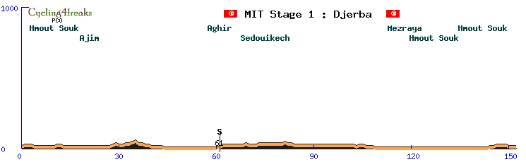
Race side :
The first stage takes place in Tunisia, at Djerba Island. A first stage for sprinters, 152 km totally flat, without a single hill. There is an intermediate sprint at km 61 at Aghir.
Km 61 Aghir (IS)
Last 5 km : 0 0 -1 0 0
Full details : http://www.radsportfreaks.de/radsport/p ... t0120final
Wiki side :
Djerba is, at 514 square kilometers (198 sq mi), the largest island of North Africa, located in the Gulf of Gabès, off the coast of Tunisia. It had a population of 139,544 at the 2004 Census which rose to 163,726 at the 2014 Census. Citing the long and unique Jewish minority's history on Djerba, Tunisia has sought UNESCO World Heritage status protections for the island.
Stage 2 : Lampedusa (Italia), 195 kms, flat, mintact km 180
Race side :
The first stage takes place in Italia, at Lampedusa Island. A second stage for sprinters, 195 km length but it is 15 times a loop of 13 km around the island in fact. There are no big difficulties too, IS at km 104.
Km 104 Lampedusa (IS)
Last 5 km : 1 1 1 1 0
Full details : http://www.radsportfreaks.de/radsport/p ... t0220final
Wiki side :
Lampedusa is the largest island of the Italian Pelagie Islands in the Mediterranean Sea.The comune of Lampedusa e Linosa is part of the Sicilian province of Agrigento which also includes the smaller islands of Linosa and Lampione. It is the southernmost part of Italy and Italy's southernmost island. Tunisia, which is about 113 kilometres (70 miles) away, is the closest landfall to the islands. Sicily is farther at 205 kilometres (127 miles), whilst the island nation of Malta is 176 kilometres (109 miles) to the east of Tunisia. In 2013, Rabbit Beach (it. "Spiaggia dei Conigli"), located in the southern part of the island, was voted the world's best beach by travel site TripAdvisor.
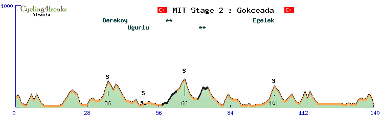
Stage 3 : Gokceada (Turkey), 140 km, hilly, mintact km 100
Race side :
We fly to Gokceada, a small turkish island where the riders will experience a short and nervous stage. The profile offers plenty of shorts climbs, where sieb is possible most of the time. 2 uphill dirt road sections will create even more opportunities for early sieb and moves. From km99 to km 115, 4 short hills offer the last sieb options (7 % max), and are followed by a flattish section until the final push. The last kms are hilly, but not impossible to block, and offer a downhill finish for a potential specialist's sprint !
In short, that stage could have plenty of different scenarios and favorites : regular sprinters, hillsprinters (of all kinds), downhill specialists able to sprint a bit, and of course breakaway warriors !
Km 30 Derekoy (cat 3), 2 km at 7,5% : 8 7
Km 50 Ugurlu (IS)
Km 66 Climb 2 (cat 3), 7 km at 3.3% : 4 4 2 2 2 6 3
Km 101 Egelek (cat 3), 2 km at 6.5% : 7 6
Last 5 kms : -1 1 4 -3 -8
Full details : http://www.radsportfreaks.de/radsport/p ... t0320final
Wiki side :
Imbros or İmroz, officially Gökçeada since 29 July 1970, is the largest island of Turkey and the seat of Gökçeada District of Çanakkale Province. It is located in the north-northeastern Aegean Sea, at the entrance of Saros Bay, and is the westernmost point of Turkey (Cape İncirburnu). Imbros has an area of 279 km2 (108 sq mi) and has some wooded areas.
According to Greek mythology, the palace of Thetis, mother of Achilles, king of Phthia, was situated between Imbros and Samothrace.
The stables of the winged horses of Poseidon were said to lie between Imbros and Tenedos.
Homer wrote in the Iliad:
“In the depths of the sea on the cliff
Between Tenedos and craggy Imbros
There is a cave, wide gaping
Poseidon who made the earth tremble,
stopped the horses there.”
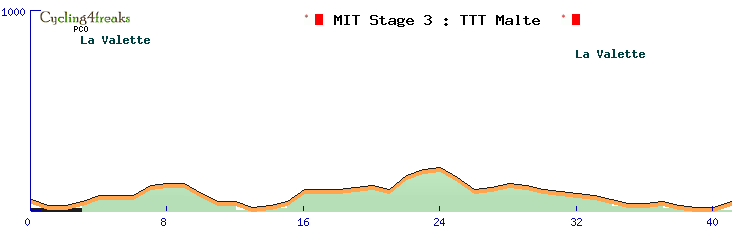
Stage 4 : Malta (Malta), 43 kms, TTT, mintact km 1
Race side :
The first stage that will create a gap between favori is the Malta TTT. A 43 km TTT with some light hills and downhills that can be complicated to manage. We start at La Valette, heading west of the island before returning to La Valette.
Full details : http://www.radsportfreaks.de/radsport/p ... t0420final
Wiki side :
Malta, officially known as the Republic of Malta and formerly Melita, is a Southern European island country consisting of an archipelago in the Mediterranean Sea. It lies 80 km (50 mi) south of Italy, 284 km (176 mi) east of Tunisia, and 333 km (207 mi) north of Libya. With a population of about 515,000 over an area of 316 km2 (122 sq mi), Malta is the world's tenth smallest country in area and fourth most densely populated sovereign country. Its capital is Valletta, which is the smallest national capital in the European Union by area at 0.8 km2 (0.31 sq mi).
The Maltese islands are home to a wide diversity of indigenous, sub-endemic and endemic plants. They feature many traits typical of a Mediterranean climate, such as drought resistance. The most common indigenous trees on the islands are olive (Olea europaea), carob (Ceratonia siliqua), fig (ficus carica), holm oak (Quericus ilex) and Aleppo pine (Pinus halpensis), while the most common non-native trees are eucalyptus, acacia and opuntia.
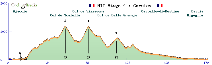
Stage 5 : Corsica (France), 172 km, middle mountain, mintact km 147
Race side :
And now direction France and Corsica island. 172 km between Ajaccio and Bastia where everything can happen, a MS like GK move. IS is km 10, and we have 3 mountains, Scalella, Vizzanova and Belle Granaje but they are in the first part of the stage.
Km 10 Ajaccio (IS)
Km 49 Scalella (cat 1), 7 km at 5,9% : 3 6 7 7 7 8 3
Km 69 Vizzanova (cat 1), 8 km at 6,9% : 4 7 5 9 10 7 9 4
Km 93 Belle Granaje (cat 3), 7 km at 4,2% : 3 5 3 6 5 4 4
Last 5 km : 1 -2 1 -1 1
Full details : http://www.radsportfreaks.de/radsport/p ... t0520final
Wiki side :
Corsica is an island in the Mediterranean Sea and politically one of the 18 regions of France. It lies southeast of the French mainland, west of the Italian Peninsula, and immediately north of the Italian island of Sardinia, the land mass nearest to it. A single chain of mountains makes up two-thirds of the island.
The island has a natural park (Parc Naturel Régional de Corse, Parcu di Corsica), which protects rare animal and plant species. The Park was created in 1972 and includes the Golfe de Porto, the Scandola Nature Reserve (a UNESCO World Heritage Site), and some of the highest mountains on the island.
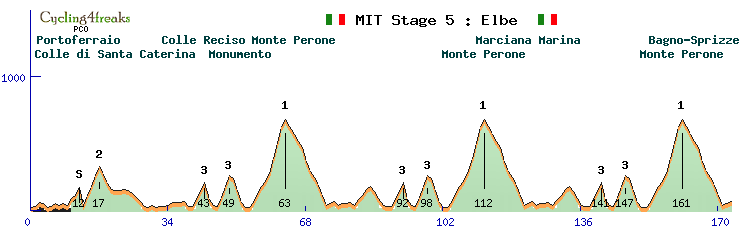
Stage 6 : Elba (Italia), 173 km, mountain, mintact km 140
Race side :
Direction Elba Island for an explosive mountain stage. Starting at Portoferraio, the peloton will face 3 times the terrible Monte Perone and its 3 km part over 11% (max 13%). The last time just before the finish at Bagno-Sprizze. Colle Reciso and Monumento will exhaust the riders a lot during this stage where GK fights promise to be interesting.
Km 12 Santa Caterina (IS)
Km 17 Colle di Santa Caterina (cat 2), 4 km at 7,3% : 7 7 8 7
Km 43 Colle Reciso (cat 3), 3 km at 6% : 5 6 7
Km 49 Monumento (cat 3), 3 km at 7,7% : 7 8 8
Km 63 Monte Perone (cat 1), 9 km at 7,3% : 4 6 6 4 6 11 11 13 5
Km 92 Colle Reciso (cat 3), 3 km at 6% : 5 6 7
Km 98 Monumento (cat 3), 3 km at 7,7% : 7 8 8
Km 112 Monte Perone (cat 1), 9 km at 7,3% : 4 6 6 4 6 11 11 13 5
Km 141 Colle Reciso (cat 3), 3 km at 6% : 5 6 7
Km 147 Monumento (cat 3), 3 km at 7,7% : 7 8 8
Km 161 Monte Perone (cat 1), 9 km at 7,3% : 4 6 6 4 6 11 11 13 5
Last 5 kms : -6 -8 -7 1 2
Full details : http://www.radsportfreaks.de/radsport/p ... t0620final
Wiki side :
Elba is a Mediterranean island in Tuscany, Italy, 10 kilometres (6.2 mi) from the coastal town of Piombino on the Italian mainland, and the largest island of the Tuscan Archipelago. It is also part of the Arcipelago Toscano National Park, and the third largest island in Italy, after Sicily and Sardinia. It is located in the Tyrrhenian Sea about 50 kilometres (30 mi) east of the French island of Corsica.
Elba is famous as the site of Napoleon's first exile, in 1814–15.
The island has a network of trails for road racers looking for more technical routes for their training, trails and dirt roads for bikers to have fun on, and accessible routes for families with children who need safe and relaxing routes. On the road from Rio nell'Elba going to Porto Azzurro is the "Fonte di Coppi". Towards the end of his career Fausto Coppi, the "campionissimo", came here to train on the roads of Elba. He still retained a celebrity status but was no longer at the peak of his career that ended with his death a few years later. The plaque on the fountain reads: "1960–2010, here the champion quenched his thirst, since fifty years on the run".
Stage 7 : Ibiza (Spain), 133 km, hilly, mintact km 90
Race side :
A short stage with a lot of short but hard difficulties. If only Can Vengut (km 42) and Cala de Sant Vincent (km 94) count as GPM, the rest of the race is never totally flat.
Km 42 Can Vengut (cat 3), 3 km at 6% : 5 6 7
Km 63 San Miguel de Balansat (IS)
Km 94 Cala de Sant Vincent (cat 3), 3 km at 7,7% : 7 8 8
Last 5 kms : -2 -1 0 1 0
Full details : http://www.radsportfreaks.de/radsport/p ... t0720final
Wiki side :
Ibiza is a Spanish island in the Mediterranean Sea off the eastern coast of Spain. It is 150 kilometres (93 miles) from the city of Valencia. It is the third largest of the Balearic Islands, an autonomous community of Spain. Its largest settlements are Ibiza Town (Catalan: Vila d'Eivissa, or simply Vila), Santa Eulària des Riu, and Sant Antoni de Portmany. Its highest point, called Sa Talaiassa (or Sa Talaia), is 475 metres (1,558 feet) above sea level.
Ibiza has become well known for its association with nightlife, electronic dance music and for the summer club scene, all of which attract large numbers of tourists. The island's government and the Spanish Tourist Office have worked toward promoting more family-oriented tourism.
Ibiza is a UNESCO World Heritage Site. Ibiza and the nearby island of Formentera to its south are called the Pine Islands, or "Pityuses".
RESTDAY
Wiki side :
The Mediterranean Sea is a sea connected to the Atlantic Ocean, surrounded by the Mediterranean Basin and almost completely enclosed by land: on the north by Southern Europe and Anatolia, on the south by North Africa, and on the east by the Levant.
Ten largest islands by area:
Country Island Area in km2 Population
Italy Sicily 25,460 5,048,995
Italy Sardinia 23,821 1,672,804
Cyprus Cyprus 9,251 1,088,503
France Corsica 8,680 299,209
Greece Crete 8,336 623,666
Greece Euboea 3,655 218.000
Spain Majorca 3,640 869,067
Greece Lesbos 1,632 90,643
Greece Rhodes 1,400 117,007
Greece Chios 842 51,936
Stage 8 : Krk (Croatia), 160 km, flat, km 129
Race side :
A flat stage in Croatia. Krk island welcomes the race and a final circuit offers the sprinters a chance to take the win. The categorized (4cat) climb of the final circuit is a 6 %, the only sieb possible. The final km is uphill, but nothing impossible to block for organized sprint teams. Offensive riders could of course try things on such circuits. 2 early pavé sections in small towns early in the race and a steep climb (8%) near the start could spice thnigs up !
Km 5 Climb 1 (cat 4), 3 km at 5.3% : 5 8 3
Km 43 Malinska (IS)
Km 65 Gabonjin (cat 4), 1 km at 6%
Km 97 Gabonjin (cat 4), 1 km at 6%
Km 129 Gabonjin (cat 4), 1 km at 6%
Last 5 kms : 1 3 2 2 1
Full details : http://www.radsportfreaks.de/radsport/p ... t0820final
Wiki side :
Krk is a Croatian island in the northern Adriatic Sea, located near Rijeka in the Bay of Kvarner and part of Primorje-Gorski Kotar county. Krk is the largest Adriatic island, with an area of 405.80 km2 (156.68 sq mi), Krk is the most populous island in the Adriatic Sea, with multiple towns and villages that contain a total of 19,383 (2011) inhabitants.
Krk is a popular tourist destination, due to its proximity to Slovenia, southern Germany, Austria, and northern Italy. Since the collapse of the Eastern Bloc, many tourists have appeared from Hungary, Romania, and other former Eastern Bloc countries.
Stage 9 : Brač (Croatia), 166 km, hilly paves, mintact km 151
Race side :
A sprint is also possible here ! But probably with not all sprinters. Or maybe with no real sprinters and only riders who attacked in that tricky circuit.
The climb in the final lap is 5 % max (3 3 5 5 5 1 1 2 -1 4** 4 ) with a short dirt road section.
2 early climbs are way more steep, will someone sieb here ?
Km 29 1St climb (cat 3), 6 km at 6% : 5 7 6 6 7 5 / dirty road -3 2** 2** -2**
Km 60 Obrsje (cat 2) 8 km at 7% : 3 9 8 8 7 9 6 6
Km 94 Lozisca (IS)
Km 124 Lozisca (cat 3), 3 km at 5% : 5 5 5
Km 154 Lozisca (cat 3), 3 km at 5% : 5 5 5
Last 5 kms : -8 -8 -3 -6 -0
Full details : http://www.radsportfreaks.de/radsport/p ... t0920final
Wiki side :
Brač is an island in the Adriatic Sea within Croatia, with an area of 396 square kilometres, making it the largest island in Dalmatia, and the third largest in the Adriatic. It is separated from the mainland by the Brač Channel, which is 5 to 13 km wide. The island's tallest peak, Vidova gora, or Mount St. Vid, stands at 780 m, making it the highest island point of the Adriatic islands. The island has a population of 13,956, living in numerous settlements, ranging from the main town Supetar, with more than 3,300 inhabitants, to Murvica, where less than two dozen people live. Brač Airport on Brač is the largest airport of all islands surrounding Split.
Stage 10 : Cyprus (Cyprus),, 176 km, flat, mintact km 151
Race side :
Nicosie – Limassol, the last chance for sprinters ! No big difficulties in the roas, soi t will be hard for braves in the escape to beat the peloton !
Km 89 Larcana (IS)
Last 5 kms : 0 -1 0 0 1
Full details : http://www.radsportfreaks.de/radsport/p ... t1020final
Wiki side :
Cyprus, officially called the Republic of Cyprus, is an island country in the Eastern Mediterranean. The third largest and third most populous island in the Mediterranean, it is located south of Turkey; west of Syria and Lebanon; north of Egypt, Israel and southeast of Greece.
The earliest known human activity on the island dates to around the 10th millennium BC. Archaeological remains from this period include the well-preserved Neolithic village of Khirokitia, and Cyprus is home to some of the oldest water wells in the world.
A well known traditional art that dates at least from the 14th century is the Lefkara Lace (also known as "Lefkaratika", which originates from the village Lefkara. Lefkara lace is recognised as an intangible cultural heritage (ICH) by Unesco, and it is characterised by distinct design patterns, and its intricate, time-consuming production process. A genuine Lefkara lace with full embroidery can take typically hundreds of hours to be made, and that is why it is usually priced quite high.
Stage 11 : Pantelleria (Italia), 178 km, mountain, mintact km 153
Race side :
The final week-end of MIT arrives soon. We are back in Italia, at Pantelleria island. 178 km between Scauri and Montagna Grande. There are 8 GPM during this hard stage : Martingana, Khamna and Sciuveki 2 times, the terrible Muro de Burgeber and the final climb to Montagna Grande, and its last km at 14%. The show will be exceptionnal !
Km 10 Martingana (cat 3), 4 km at 5,8% : 5 7 5 6
Km 15 Khamna (cat 3), 1 km at 11%
Km 24 Sciuveki (cat 3), 3 km at 6,3% : 6 7 6
Km 63 Scauri (IS)
Km 73 Martingana (cat 3), 4 km at 5,8% : 5 7 5 6
Km 78 Khamna (cat 3), 1 km at 11% : 11
Km 87 Sciuveki (cat 3), 3 km at 6,3% : 6 7 6
Km 155 Muro di Burgeber (cat 2), 3 km at 8.3% : 5 6 14
Km 174 Montagna Grande (cat 1), 6 km at 9,3% : 7 6 10 11 8 14
Lasts 10 km : -8 2 -2 0 6 10 11 8 14
Full details : http://www.radsportfreaks.de/radsport/p ... t1120final
Wiki side :
Pantelleria , the ancient Cossyra or Cossura, is an Italian island and comune in the Strait of Sicily in the Mediterranean Sea, 100 km (62 mi) southwest of Sicily and 60 km (37 mi) east of the Tunisian coast. On clear days Tunisia is visible from the island. Administratively Pantelleria's comune belongs to the Sicilian province of Trapani.
With an area of 83 km2 (32 sq mi), it is the largest volcanic satellite island of Sicily. The last eruption occurred below sea level in 1891, and today phenomena related to volcanic activity can be observed, such as hot springs and fumaroles.
The highest peak, the Montagna Grande, reaches 836 m (2,743 ft) above sea level.
Pantelleria National Park was established in 2016, and covers an area of 66.4 km2 (25.6 sq mi), or 80% of the island.
A Middle Bronze Age village was on the west coast, 3 km (1.9 mi) southeast of the harbour, with a rampart of small blocks of lava, about 7.5 m (25 ft) high, 10 m (33 ft) wide at the base and 5 m (16 ft) at the top, upon the undefended eastern side. Remains of huts were found there, with pottery, tools of obsidian, and other artifacts. These objects are in the museum at Syracuse.
Pantelleria is noted for its sweet wines, Moscato di Pantelleria and Moscato Passito di Pantelleria, both made from the local Zibibbo grape.
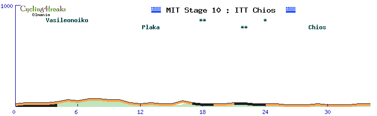
Stage 12 : Chios (Greece), ITT, mintact km 1
Race side :
Welcome to Chios island for an ITT of 34kms. The route is flat (max 3%), for specialists. The key for the win between specialists ? Their ability to keep a fast tempo on the dirt road sections (5kms in total).
34Kms is long enough to see some leaders with low reg think twice about going full speed in that TT knowing the last stage is quite something !
Full details : http://www.radsportfreaks.de/radsport/p ... t1220final
Wiki side :
Chios is the fifth largest of the Greek islands, situated in the northern Aegean Sea. The island is separated from Turkey by the Chios Strait. Chios is notable for its exports of mastic gum and its nickname is "the Mastic Island". Tourist attractions include its medieval villages and the 11th-century monastery of Nea Moni, a UNESCO World Heritage Site.
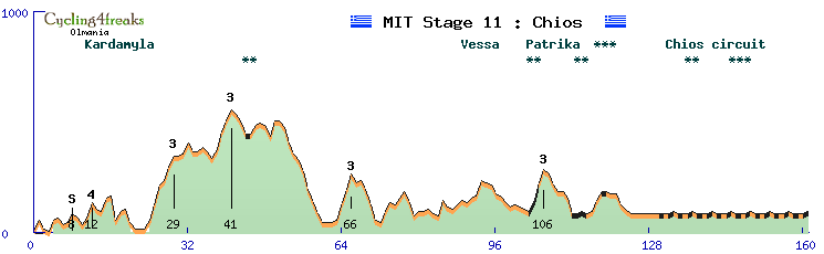
Stage 13 : Chios (Greece), 161 km, flat pave, mintact km 131

Race side :
Final stage of the tour, in Chios, and what a stage ! During 120kms, it’s ups and downs non stop, with only a few dirt road sections. Early sieb is possible in all categorized climbs and sometimes even in uncategorized climbs.
And then, the last 30kms offer an intense circuit with a dirt road section and a serious pavé section in the city. It’s only ** for dirt roads and *** for the pavé section, but it’s almost non stop for 30kms, so we expect gaps to be opened and GC to see final changes here.
Km 8 Kardamyla (IS)
Km 12 Kardamyla (cat 4), 2 km at 5% : 3 7
Km 29 Climb 2 (cat 3), 6 km at 5,2% : 4 7 9 2 6 5
Km 41 Climb 3 (cat 3), 4 km at 5,5% : 4 8 5 5
Km 66 Climb 4 (cat 3), 3 km at 7% : 8 6 7
Km 106 Climb 5 (cat 3), 3 km at 6.3% : 5 8 6
Last 5 km : 1** -1 0*** 0 1**
Full details : http://www.radsportfreaks.de/radsport/p ... t1320final
Wiki side :
The island's climate is warm and moderate, categorised as Temperate, Mediterranean (Csa), with modest variation due to the stabilising effect of the surrounding sea. Average temperatures normally range from a summer high of 27 °C (81 °F) to a winter low of 11 °C (52 °F) in January, although temperatures of over 40 °C (104 °F) or below freezing can sometimes be encountered.
The presentation of MIT finishes here, we hope you enjoy it !
First collaboration of the history between OL & Pokemon, Mediterranean Islands Tour (MIT), which visit 9 differents countries, is a tour that offers opportunities for various kinds of riders. Actually, almost all kinds of riders. And the GC fight might not be (only) a climber's affair. Why so ? Because 2020 was already a dream year for climbers with plenty of GC, stages and jerseys to win. More than the past years. So, MIT gives a chance for other kinds of leaders to compete for a long tour win !
Having dirt roads and pavés sections is something that might give a challenge for climbers; and having 1 ITT and 1 TTT is also challenging for GC competition.
Many stages are open, which means that the favorites of the stage will depend on the scenarii and the line-up of each tour. Many stages could be nervous, with fears of GC moves in various parts of stages, especially if the GC contenders are not only climbers and can be offensive on flatish/hilly stages.
Sprinters will have their word to say of course. Sprint stages are not all that easy, but some hilly stages could end up in a MS in case no one decides to spice up the race early enough.
Riders will visit many mediteranean islands during these 2 weeks times, and unlinke during 2020 Giro, they won't complain about waking up at 6am for early transfers by plane or boat. There is actually a ferry and a plane that are reserved for the race staff and riders !
Stage 1 : Djerba (Tunisia), 152 km, flat, mintact km 137
Race side :
The first stage takes place in Tunisia, at Djerba Island. A first stage for sprinters, 152 km totally flat, without a single hill. There is an intermediate sprint at km 61 at Aghir.
Km 61 Aghir (IS)
Last 5 km : 0 0 -1 0 0
Full details : http://www.radsportfreaks.de/radsport/p ... t0120final
Wiki side :
Djerba is, at 514 square kilometers (198 sq mi), the largest island of North Africa, located in the Gulf of Gabès, off the coast of Tunisia. It had a population of 139,544 at the 2004 Census which rose to 163,726 at the 2014 Census. Citing the long and unique Jewish minority's history on Djerba, Tunisia has sought UNESCO World Heritage status protections for the island.
Stage 2 : Lampedusa (Italia), 195 kms, flat, mintact km 180
Race side :
The first stage takes place in Italia, at Lampedusa Island. A second stage for sprinters, 195 km length but it is 15 times a loop of 13 km around the island in fact. There are no big difficulties too, IS at km 104.
Km 104 Lampedusa (IS)
Last 5 km : 1 1 1 1 0
Full details : http://www.radsportfreaks.de/radsport/p ... t0220final
Wiki side :
Lampedusa is the largest island of the Italian Pelagie Islands in the Mediterranean Sea.The comune of Lampedusa e Linosa is part of the Sicilian province of Agrigento which also includes the smaller islands of Linosa and Lampione. It is the southernmost part of Italy and Italy's southernmost island. Tunisia, which is about 113 kilometres (70 miles) away, is the closest landfall to the islands. Sicily is farther at 205 kilometres (127 miles), whilst the island nation of Malta is 176 kilometres (109 miles) to the east of Tunisia. In 2013, Rabbit Beach (it. "Spiaggia dei Conigli"), located in the southern part of the island, was voted the world's best beach by travel site TripAdvisor.
Stage 3 : Gokceada (Turkey), 140 km, hilly, mintact km 100
Race side :
We fly to Gokceada, a small turkish island where the riders will experience a short and nervous stage. The profile offers plenty of shorts climbs, where sieb is possible most of the time. 2 uphill dirt road sections will create even more opportunities for early sieb and moves. From km99 to km 115, 4 short hills offer the last sieb options (7 % max), and are followed by a flattish section until the final push. The last kms are hilly, but not impossible to block, and offer a downhill finish for a potential specialist's sprint !
In short, that stage could have plenty of different scenarios and favorites : regular sprinters, hillsprinters (of all kinds), downhill specialists able to sprint a bit, and of course breakaway warriors !
Km 30 Derekoy (cat 3), 2 km at 7,5% : 8 7
Km 50 Ugurlu (IS)
Km 66 Climb 2 (cat 3), 7 km at 3.3% : 4 4 2 2 2 6 3
Km 101 Egelek (cat 3), 2 km at 6.5% : 7 6
Last 5 kms : -1 1 4 -3 -8
Full details : http://www.radsportfreaks.de/radsport/p ... t0320final
Wiki side :
Imbros or İmroz, officially Gökçeada since 29 July 1970, is the largest island of Turkey and the seat of Gökçeada District of Çanakkale Province. It is located in the north-northeastern Aegean Sea, at the entrance of Saros Bay, and is the westernmost point of Turkey (Cape İncirburnu). Imbros has an area of 279 km2 (108 sq mi) and has some wooded areas.
According to Greek mythology, the palace of Thetis, mother of Achilles, king of Phthia, was situated between Imbros and Samothrace.
The stables of the winged horses of Poseidon were said to lie between Imbros and Tenedos.
Homer wrote in the Iliad:
“In the depths of the sea on the cliff
Between Tenedos and craggy Imbros
There is a cave, wide gaping
Poseidon who made the earth tremble,
stopped the horses there.”
Stage 4 : Malta (Malta), 43 kms, TTT, mintact km 1
Race side :
The first stage that will create a gap between favori is the Malta TTT. A 43 km TTT with some light hills and downhills that can be complicated to manage. We start at La Valette, heading west of the island before returning to La Valette.
Full details : http://www.radsportfreaks.de/radsport/p ... t0420final
Wiki side :
Malta, officially known as the Republic of Malta and formerly Melita, is a Southern European island country consisting of an archipelago in the Mediterranean Sea. It lies 80 km (50 mi) south of Italy, 284 km (176 mi) east of Tunisia, and 333 km (207 mi) north of Libya. With a population of about 515,000 over an area of 316 km2 (122 sq mi), Malta is the world's tenth smallest country in area and fourth most densely populated sovereign country. Its capital is Valletta, which is the smallest national capital in the European Union by area at 0.8 km2 (0.31 sq mi).
The Maltese islands are home to a wide diversity of indigenous, sub-endemic and endemic plants. They feature many traits typical of a Mediterranean climate, such as drought resistance. The most common indigenous trees on the islands are olive (Olea europaea), carob (Ceratonia siliqua), fig (ficus carica), holm oak (Quericus ilex) and Aleppo pine (Pinus halpensis), while the most common non-native trees are eucalyptus, acacia and opuntia.
Stage 5 : Corsica (France), 172 km, middle mountain, mintact km 147
Race side :
And now direction France and Corsica island. 172 km between Ajaccio and Bastia where everything can happen, a MS like GK move. IS is km 10, and we have 3 mountains, Scalella, Vizzanova and Belle Granaje but they are in the first part of the stage.
Km 10 Ajaccio (IS)
Km 49 Scalella (cat 1), 7 km at 5,9% : 3 6 7 7 7 8 3
Km 69 Vizzanova (cat 1), 8 km at 6,9% : 4 7 5 9 10 7 9 4
Km 93 Belle Granaje (cat 3), 7 km at 4,2% : 3 5 3 6 5 4 4
Last 5 km : 1 -2 1 -1 1
Full details : http://www.radsportfreaks.de/radsport/p ... t0520final
Wiki side :
Corsica is an island in the Mediterranean Sea and politically one of the 18 regions of France. It lies southeast of the French mainland, west of the Italian Peninsula, and immediately north of the Italian island of Sardinia, the land mass nearest to it. A single chain of mountains makes up two-thirds of the island.
The island has a natural park (Parc Naturel Régional de Corse, Parcu di Corsica), which protects rare animal and plant species. The Park was created in 1972 and includes the Golfe de Porto, the Scandola Nature Reserve (a UNESCO World Heritage Site), and some of the highest mountains on the island.
Stage 6 : Elba (Italia), 173 km, mountain, mintact km 140
Race side :
Direction Elba Island for an explosive mountain stage. Starting at Portoferraio, the peloton will face 3 times the terrible Monte Perone and its 3 km part over 11% (max 13%). The last time just before the finish at Bagno-Sprizze. Colle Reciso and Monumento will exhaust the riders a lot during this stage where GK fights promise to be interesting.
Km 12 Santa Caterina (IS)
Km 17 Colle di Santa Caterina (cat 2), 4 km at 7,3% : 7 7 8 7
Km 43 Colle Reciso (cat 3), 3 km at 6% : 5 6 7
Km 49 Monumento (cat 3), 3 km at 7,7% : 7 8 8
Km 63 Monte Perone (cat 1), 9 km at 7,3% : 4 6 6 4 6 11 11 13 5
Km 92 Colle Reciso (cat 3), 3 km at 6% : 5 6 7
Km 98 Monumento (cat 3), 3 km at 7,7% : 7 8 8
Km 112 Monte Perone (cat 1), 9 km at 7,3% : 4 6 6 4 6 11 11 13 5
Km 141 Colle Reciso (cat 3), 3 km at 6% : 5 6 7
Km 147 Monumento (cat 3), 3 km at 7,7% : 7 8 8
Km 161 Monte Perone (cat 1), 9 km at 7,3% : 4 6 6 4 6 11 11 13 5
Last 5 kms : -6 -8 -7 1 2
Full details : http://www.radsportfreaks.de/radsport/p ... t0620final
Wiki side :
Elba is a Mediterranean island in Tuscany, Italy, 10 kilometres (6.2 mi) from the coastal town of Piombino on the Italian mainland, and the largest island of the Tuscan Archipelago. It is also part of the Arcipelago Toscano National Park, and the third largest island in Italy, after Sicily and Sardinia. It is located in the Tyrrhenian Sea about 50 kilometres (30 mi) east of the French island of Corsica.
Elba is famous as the site of Napoleon's first exile, in 1814–15.
The island has a network of trails for road racers looking for more technical routes for their training, trails and dirt roads for bikers to have fun on, and accessible routes for families with children who need safe and relaxing routes. On the road from Rio nell'Elba going to Porto Azzurro is the "Fonte di Coppi". Towards the end of his career Fausto Coppi, the "campionissimo", came here to train on the roads of Elba. He still retained a celebrity status but was no longer at the peak of his career that ended with his death a few years later. The plaque on the fountain reads: "1960–2010, here the champion quenched his thirst, since fifty years on the run".
Stage 7 : Ibiza (Spain), 133 km, hilly, mintact km 90
Race side :
A short stage with a lot of short but hard difficulties. If only Can Vengut (km 42) and Cala de Sant Vincent (km 94) count as GPM, the rest of the race is never totally flat.
Km 42 Can Vengut (cat 3), 3 km at 6% : 5 6 7
Km 63 San Miguel de Balansat (IS)
Km 94 Cala de Sant Vincent (cat 3), 3 km at 7,7% : 7 8 8
Last 5 kms : -2 -1 0 1 0
Full details : http://www.radsportfreaks.de/radsport/p ... t0720final
Wiki side :
Ibiza is a Spanish island in the Mediterranean Sea off the eastern coast of Spain. It is 150 kilometres (93 miles) from the city of Valencia. It is the third largest of the Balearic Islands, an autonomous community of Spain. Its largest settlements are Ibiza Town (Catalan: Vila d'Eivissa, or simply Vila), Santa Eulària des Riu, and Sant Antoni de Portmany. Its highest point, called Sa Talaiassa (or Sa Talaia), is 475 metres (1,558 feet) above sea level.
Ibiza has become well known for its association with nightlife, electronic dance music and for the summer club scene, all of which attract large numbers of tourists. The island's government and the Spanish Tourist Office have worked toward promoting more family-oriented tourism.
Ibiza is a UNESCO World Heritage Site. Ibiza and the nearby island of Formentera to its south are called the Pine Islands, or "Pityuses".
RESTDAY
Wiki side :
The Mediterranean Sea is a sea connected to the Atlantic Ocean, surrounded by the Mediterranean Basin and almost completely enclosed by land: on the north by Southern Europe and Anatolia, on the south by North Africa, and on the east by the Levant.
Ten largest islands by area:
Country Island Area in km2 Population
Italy Sicily 25,460 5,048,995
Italy Sardinia 23,821 1,672,804
Cyprus Cyprus 9,251 1,088,503
France Corsica 8,680 299,209
Greece Crete 8,336 623,666
Greece Euboea 3,655 218.000
Spain Majorca 3,640 869,067
Greece Lesbos 1,632 90,643
Greece Rhodes 1,400 117,007
Greece Chios 842 51,936
Stage 8 : Krk (Croatia), 160 km, flat, km 129
Race side :
A flat stage in Croatia. Krk island welcomes the race and a final circuit offers the sprinters a chance to take the win. The categorized (4cat) climb of the final circuit is a 6 %, the only sieb possible. The final km is uphill, but nothing impossible to block for organized sprint teams. Offensive riders could of course try things on such circuits. 2 early pavé sections in small towns early in the race and a steep climb (8%) near the start could spice thnigs up !
Km 5 Climb 1 (cat 4), 3 km at 5.3% : 5 8 3
Km 43 Malinska (IS)
Km 65 Gabonjin (cat 4), 1 km at 6%
Km 97 Gabonjin (cat 4), 1 km at 6%
Km 129 Gabonjin (cat 4), 1 km at 6%
Last 5 kms : 1 3 2 2 1
Full details : http://www.radsportfreaks.de/radsport/p ... t0820final
Wiki side :
Krk is a Croatian island in the northern Adriatic Sea, located near Rijeka in the Bay of Kvarner and part of Primorje-Gorski Kotar county. Krk is the largest Adriatic island, with an area of 405.80 km2 (156.68 sq mi), Krk is the most populous island in the Adriatic Sea, with multiple towns and villages that contain a total of 19,383 (2011) inhabitants.
Krk is a popular tourist destination, due to its proximity to Slovenia, southern Germany, Austria, and northern Italy. Since the collapse of the Eastern Bloc, many tourists have appeared from Hungary, Romania, and other former Eastern Bloc countries.
Stage 9 : Brač (Croatia), 166 km, hilly paves, mintact km 151
Race side :
A sprint is also possible here ! But probably with not all sprinters. Or maybe with no real sprinters and only riders who attacked in that tricky circuit.
The climb in the final lap is 5 % max (3 3 5 5 5 1 1 2 -1 4** 4 ) with a short dirt road section.
2 early climbs are way more steep, will someone sieb here ?
Km 29 1St climb (cat 3), 6 km at 6% : 5 7 6 6 7 5 / dirty road -3 2** 2** -2**
Km 60 Obrsje (cat 2) 8 km at 7% : 3 9 8 8 7 9 6 6
Km 94 Lozisca (IS)
Km 124 Lozisca (cat 3), 3 km at 5% : 5 5 5
Km 154 Lozisca (cat 3), 3 km at 5% : 5 5 5
Last 5 kms : -8 -8 -3 -6 -0
Full details : http://www.radsportfreaks.de/radsport/p ... t0920final
Wiki side :
Brač is an island in the Adriatic Sea within Croatia, with an area of 396 square kilometres, making it the largest island in Dalmatia, and the third largest in the Adriatic. It is separated from the mainland by the Brač Channel, which is 5 to 13 km wide. The island's tallest peak, Vidova gora, or Mount St. Vid, stands at 780 m, making it the highest island point of the Adriatic islands. The island has a population of 13,956, living in numerous settlements, ranging from the main town Supetar, with more than 3,300 inhabitants, to Murvica, where less than two dozen people live. Brač Airport on Brač is the largest airport of all islands surrounding Split.
Stage 10 : Cyprus (Cyprus),, 176 km, flat, mintact km 151
Race side :
Nicosie – Limassol, the last chance for sprinters ! No big difficulties in the roas, soi t will be hard for braves in the escape to beat the peloton !
Km 89 Larcana (IS)
Last 5 kms : 0 -1 0 0 1
Full details : http://www.radsportfreaks.de/radsport/p ... t1020final
Wiki side :
Cyprus, officially called the Republic of Cyprus, is an island country in the Eastern Mediterranean. The third largest and third most populous island in the Mediterranean, it is located south of Turkey; west of Syria and Lebanon; north of Egypt, Israel and southeast of Greece.
The earliest known human activity on the island dates to around the 10th millennium BC. Archaeological remains from this period include the well-preserved Neolithic village of Khirokitia, and Cyprus is home to some of the oldest water wells in the world.
A well known traditional art that dates at least from the 14th century is the Lefkara Lace (also known as "Lefkaratika", which originates from the village Lefkara. Lefkara lace is recognised as an intangible cultural heritage (ICH) by Unesco, and it is characterised by distinct design patterns, and its intricate, time-consuming production process. A genuine Lefkara lace with full embroidery can take typically hundreds of hours to be made, and that is why it is usually priced quite high.
Stage 11 : Pantelleria (Italia), 178 km, mountain, mintact km 153
Race side :
The final week-end of MIT arrives soon. We are back in Italia, at Pantelleria island. 178 km between Scauri and Montagna Grande. There are 8 GPM during this hard stage : Martingana, Khamna and Sciuveki 2 times, the terrible Muro de Burgeber and the final climb to Montagna Grande, and its last km at 14%. The show will be exceptionnal !
Km 10 Martingana (cat 3), 4 km at 5,8% : 5 7 5 6
Km 15 Khamna (cat 3), 1 km at 11%
Km 24 Sciuveki (cat 3), 3 km at 6,3% : 6 7 6
Km 63 Scauri (IS)
Km 73 Martingana (cat 3), 4 km at 5,8% : 5 7 5 6
Km 78 Khamna (cat 3), 1 km at 11% : 11
Km 87 Sciuveki (cat 3), 3 km at 6,3% : 6 7 6
Km 155 Muro di Burgeber (cat 2), 3 km at 8.3% : 5 6 14
Km 174 Montagna Grande (cat 1), 6 km at 9,3% : 7 6 10 11 8 14
Lasts 10 km : -8 2 -2 0 6 10 11 8 14
Full details : http://www.radsportfreaks.de/radsport/p ... t1120final
Wiki side :
Pantelleria , the ancient Cossyra or Cossura, is an Italian island and comune in the Strait of Sicily in the Mediterranean Sea, 100 km (62 mi) southwest of Sicily and 60 km (37 mi) east of the Tunisian coast. On clear days Tunisia is visible from the island. Administratively Pantelleria's comune belongs to the Sicilian province of Trapani.
With an area of 83 km2 (32 sq mi), it is the largest volcanic satellite island of Sicily. The last eruption occurred below sea level in 1891, and today phenomena related to volcanic activity can be observed, such as hot springs and fumaroles.
The highest peak, the Montagna Grande, reaches 836 m (2,743 ft) above sea level.
Pantelleria National Park was established in 2016, and covers an area of 66.4 km2 (25.6 sq mi), or 80% of the island.
A Middle Bronze Age village was on the west coast, 3 km (1.9 mi) southeast of the harbour, with a rampart of small blocks of lava, about 7.5 m (25 ft) high, 10 m (33 ft) wide at the base and 5 m (16 ft) at the top, upon the undefended eastern side. Remains of huts were found there, with pottery, tools of obsidian, and other artifacts. These objects are in the museum at Syracuse.
Pantelleria is noted for its sweet wines, Moscato di Pantelleria and Moscato Passito di Pantelleria, both made from the local Zibibbo grape.
Stage 12 : Chios (Greece), ITT, mintact km 1
Race side :
Welcome to Chios island for an ITT of 34kms. The route is flat (max 3%), for specialists. The key for the win between specialists ? Their ability to keep a fast tempo on the dirt road sections (5kms in total).
34Kms is long enough to see some leaders with low reg think twice about going full speed in that TT knowing the last stage is quite something !
Full details : http://www.radsportfreaks.de/radsport/p ... t1220final
Wiki side :
Chios is the fifth largest of the Greek islands, situated in the northern Aegean Sea. The island is separated from Turkey by the Chios Strait. Chios is notable for its exports of mastic gum and its nickname is "the Mastic Island". Tourist attractions include its medieval villages and the 11th-century monastery of Nea Moni, a UNESCO World Heritage Site.
Stage 13 : Chios (Greece), 161 km, flat pave, mintact km 131
Race side :
Final stage of the tour, in Chios, and what a stage ! During 120kms, it’s ups and downs non stop, with only a few dirt road sections. Early sieb is possible in all categorized climbs and sometimes even in uncategorized climbs.
And then, the last 30kms offer an intense circuit with a dirt road section and a serious pavé section in the city. It’s only ** for dirt roads and *** for the pavé section, but it’s almost non stop for 30kms, so we expect gaps to be opened and GC to see final changes here.
Km 8 Kardamyla (IS)
Km 12 Kardamyla (cat 4), 2 km at 5% : 3 7
Km 29 Climb 2 (cat 3), 6 km at 5,2% : 4 7 9 2 6 5
Km 41 Climb 3 (cat 3), 4 km at 5,5% : 4 8 5 5
Km 66 Climb 4 (cat 3), 3 km at 7% : 8 6 7
Km 106 Climb 5 (cat 3), 3 km at 6.3% : 5 8 6
Last 5 km : 1** -1 0*** 0 1**
Full details : http://www.radsportfreaks.de/radsport/p ... t1320final
Wiki side :
The island's climate is warm and moderate, categorised as Temperate, Mediterranean (Csa), with modest variation due to the stabilising effect of the surrounding sea. Average temperatures normally range from a summer high of 27 °C (81 °F) to a winter low of 11 °C (52 °F) in January, although temperatures of over 40 °C (104 °F) or below freezing can sometimes be encountered.
The presentation of MIT finishes here, we hope you enjoy it !
Who is online
Users browsing this forum: No registered users and 2 guests