To early to start thinking about? Well for me never.
You might already be able to guess why I open that topic. It's about the question if you maybe allow me to design another tour, despite having just restarted to play the game, if it's not already decided. A concept is already in my mind. But I don't want to start to do the stages unless I am allowed to design, as it is quite some work.
@Alk: Sure, as you did it last year, I think you got the last word about it. If you want to do it, you come first, I'm fine with that.
Campeonato de los Andes 2014
Moderators: systemmods, Calendarmods
-
Cerro Torre RT
- Posts: 578
- Joined: Wed Feb 17, 2010 2:44 pm
- Contact:
Re: Campeonato de los Andes 2014
It's never too early, I'd sayCerro Torre RT wrote:To early to start thinking about? Well for me never.
You might already be able to guess why I open that topic. It's about the question if you maybe allow me to design another tour, despite having just restarted to play the game, if it's not already decided. A concept is already in my mind. But I don't want to start to do the stages unless I am allowed to design, as it is quite some work.
@Alk: Sure, as you did it last year, I think you got the last word about it. If you want to do it, you come first, I'm fine with that.
-
Cerro Torre RT
- Posts: 578
- Joined: Wed Feb 17, 2010 2:44 pm
- Contact:
Presentation Campeonato de los Andes 2014
Campeonato 2014 is done, ready for presentation.
Some words about the concept headfirst: Does anyone remember the first Campeonato, back in 2006? Back then, all kilometers were ridden in one minute steps, so we had to cut out about 60% of all km to make it work in a senceful timespan. It's also bin the first Campeonato I created, and my first fantasy tour as well, I think. I was not very common with searching appropriate roads. Additionaly, Google Earth did not provide the quality of pictures we are used to now. I guess I had some very imaginative roads in the course. But the resulting profiles were interesting to ride, in my eyes, so I decided it's time to use that general route again, but this time, properly done.
Sure, I did not copy&paste the course of 2006. I don't even have got the files. I just used the same starting point, end point, and as much as I can remember where the stages were and, even more important, what kind of stages they were and their character. Based on this, I created the 2014 Campeonato de los Andes, and this is the result.
Let's start with some general facts and stats. The start is in Lima (Peru), with a prologue, and the Tour finishes in La Paz (Bolivia), with an individual time trail. There are 15 stages and one rest day, so the Tour will start on Saturday and end on Sunday two weeks later. The following two maps show where the stages are. The colors of the stages have the following meaning:
Green - flat stage
Yellow - medium mountain stage
Red - mountain stage
Blue - individual time trail
As you can see, the race consists of 2 flat stages, 2 medium mountain stages, 8 mountain stages (of those, 3 finishes at the top, 3 after downhill, and 2 after longer passages that are more or less flat) and 3 individual time trails, of which one is a prologue and one a mountain time trail. Overall, there are 2498 km to be ridden, of which 83 are in time trails. Total hight meters to climb are 46300. The change to minute tact will occur aproximatly 39 km before the finish in average.
The rest day will be after stage 7 in Cuzco, thus on a Saturday.
Every non time trail stage will contain one intermediate sprint and 0 to 5 mountain intermediates, 29 in total. Don't worry if the categories seem to be low, the mountains are hard nevertheless. In order not to overload the tour with intermediates, the mountains have been classified in relative difficulty to each other. As there are some extreme mountains to climb, quite hard ones might end up only getting Category 3 or 4.
The whole tour was created using Google Earth and the Excel editor. Automatic tools were not used, due to the quite often accuring delay of roads, pictures and terrain that would lead to wrong results.Stage 1: Prologue Lima
Stage 1: Prologue Lima
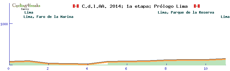
stage type: individual time trail
Length: 11 km
hight meters to climb: 150 m
start of min tact: all
duration: 11 min
For the first stage, in order to present the riders and provide some sort of starting order to the race, a prologue is held in Lima. From the city centre, the race leads down to the coast and later up again to Miraflores, to finish at the Parque de la Reserva. With 11 km, it's quite a long prologue, and not completly flat (with one km at 6%). As none of the time trails in the tour is truely flat, this one might provide the best chances for the specialists to take a stage win.
Stage 2: Lima to Pisco
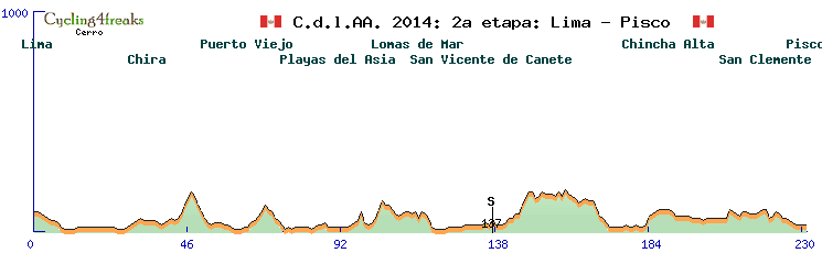
stage type: flat stage
Length: 231 km
hight meters to climb: 1150 m
start of min tact: 27 before finish
duration: 2 h 19 min (including sprint)
The second stage is a long flat stage and follows the coastline southwards. Nearly al of the stage is on the Panamerica. There is no kilometer steeper than 4%, and due to that, no mountain that was hard enough to earn a categorization. If there are as many sprinters joining the tour as usually, this stage will probably be one for an escaping group.
Stage 3: Laguna Grande to Nazca
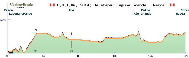
stage type: medium mountain stage
Length: 220 km
hight meters to climb: 2060 m
start of min tact: 34 before finish
duration: 2 h 17 min (including sprint)
categorized mountains:
Kat 4 - 14 km - Ø 3,8% - max. 7%
Finally, on the 3rd stage there will be some hills to climb. Most of them are to short to be categorized, but there is one mountain intermediate at a long, but not very steep climb in the first part of the stage. The stage is started near Pisco, and leads further south, but not on the Panamerica. Instead, the track leads away from the coast, but does not enter the Andes yet. The last hill with kilometers steeper than 5% is 27km before the finish in Nazca.
Stage 4: Nazca to Puquoi
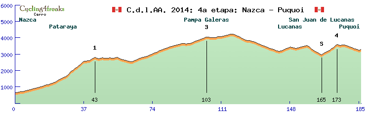
stage type: HC mountain stage
Length: 186 km
hight meters to climb: 5160 m
start of min tact: 44 before finish
duration: 2 h 05 min (including sprint)
categorized mountains:
Kat 1 - 43 km - Ø 5,0% - max. 13%
Pampa Galeras Kat 3 - 40 km - Ø 3,8% - max. 6%
Kat 4 - 8 km - Ø 7,9% - max. 11%
There we go, starting at just around 500m, to climb the first pass of nearly 4000m. From Nazca, the course is leading west, straight into the Andes. The first big climb doesn't look too steep if looking at the average percantage, but those include the first 20 km that do not exceed 5%. The rest of climb is much steeper, making it one of the 4 hardest climbes of the tour. After a short flat passage and downhill, the rest of the climb to the national park of Pampa Galeras has to be climbed, which is not nearly as steep as the Kat 1. A very important climb will be the Kat 4 - mountain. From there, it's 6 quite flat km and 6km downhill to the last kilometer, which is at 5%. That might hurt some cooperations on the kilometers from the last mountain, as some time differences may occur here. A quite demanding start for the climbers, and there's more to come just the next day.
Stage 5: Chipoa to Querobamba
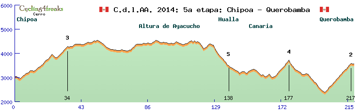
stage type: HC mountain arrival
Length: 219 km
hight meters to climb: 5320 m
start of min tact: 53 before finish
duration: 2 h 26 min (including sprint)
categorized mountains:
Kat 3 - 31 km - Ø 4,0% - max. 8%
Kat 4 - 11 km - Ø 6,5% - max. 9%
Kat 2 - 17 km - Ø 7,1% - max. 10%
The second HC stage is the first mountain arrivel of the tour. After a transfer of about 60 km, the stage starts in Chipoa, immediatly beginnig the first climb of the day. After a short downhill and another short climb, one of the typical high plains has to be crossed. Staying on the same level nearly, there are quite some ups and downs that won't make it to easy for the riders. After a long downhill, splitted by another climb, the riders arrive at the final climb. As it is a long and difficult one, expect quite some time differentials to occur.
Stage 6: Pomacocha to Andahuaylas
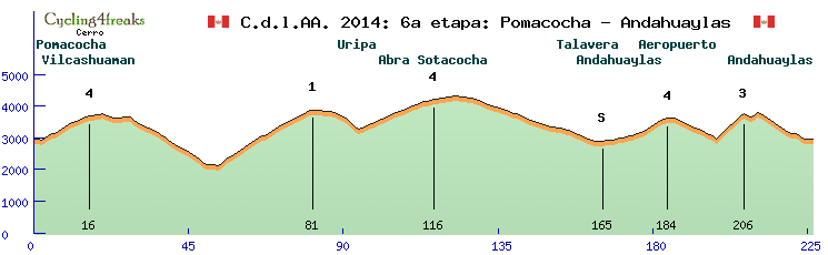
stage type: HC mountain stage
Length: 226 km
hight meters to climb: 5460 m
start of min tact: 57 before finish
duration: 2 h 32 min (including sprint)
categorized mountains:
Kat 4 - 14 km - Ø 5,6% - max. 8%
Kat 1 - 28 km - Ø 6,3% - max. 10%
Abra Sotacocha Kat 4 - 22 km - Ø 4,4% - max. 6%
Aeropuerto de Andahuaylas Kat 4 - 14 km - Ø 4,6% - max. 8%
Kat 3 - 8 km - Ø 9,8% - max. 12%
Another transfer of about 70 km leads the riders to the start of the next stage. Crossing the Andes in one of their widest areas, there's not much room but to ad another difficult stage. This time, there are not a lot of flat km, as the race is mostly up and down. Starting with a smaller mountain of only 14 km in length, a long descend follows to the lowest point of the day. Here starts the 2nd of just 3 Kat 1 mountains, so it's a very tough one. A short downhil and a less steep climb to Abra Sotacocha is followed by the descent to Andahuaylas, from where another 2 mountains have to be climbed. The last one may be short, but features the highest average percentage of all climbs of the tour. Pay attention to the 2 steep km that follow after a short downhill, as they are 6% and 8% as well. Due to it's lenght and the number of climbs, this might be the most difficult stage for the grupetto.
Stage 7: Abancay to Cuzco
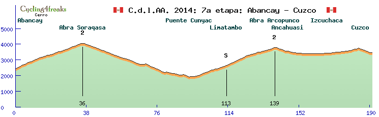
stage type: HC mountain stage
Length: 191 km
hight meters to climb: 3960 m
start of min tact: 25 before finish
duration: 1 h 58 min (including sprint)
categorized mountains:
Abra Soraqasa Kat 2 - 36 km - Ø 4,5% - max. 7%
Abra Arcopunco Kat 2 - 42 km - Ø 4,4% - max. 6%
And yet again, another HC stage. But this time, the character is completly different. Starting in Abancay (transfer of 50 km approximatly), Abra Soraqasa and Abra Arcopunco have to be climbed. Both are very similar climbs: Long, but not very steep. After Abra Arcopunco, no kilometer is exceeding 5%. Thus, this is probably not a stage for climbers. Yet, nearly 4000 hm clearly show that this is a very demanding stage nevertheless.
after Stage 7: Rest day (Saturday)
After those difficult stages, the riders really deserve this one. Yet, they are not completly free of tasks, as they have to do a transfer to the peruanian jungle (approximatly 250 km), in order to start next days stage.
Stage 8: Pilcopata to Catsa
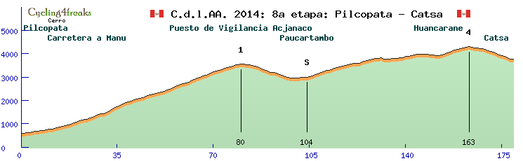
stage type: HC mountain stage
Length: 179 km
hight meters to climb: 4470 m
start of min tact: 28 before finish
duration: 1 h 54 min (including sprint)
categorized mountains:
Puesto de Vigilancia Acjanaco Kat 1 - 80 km - Ø 3,1% - max. 7%
Kat 4 - 59 km - Ø 2,3% - max. 5%
Well, what may a Campeonato stage look like after a transfer deep down to the yungle? Sure, a hard mountain stage with a long climb in the start hast to follow. Don't let you trick by the low average percentage, there's also a longer part of 6 and 7% kilometers. But overall, it's clearly the lenght that gets it category 1. After the summit, no upwards kilometer is steeper than 5%. Thus, the race is more suited to classic riders than to mountain specialists. GC candidates may try to hold back anyway, as they need their power the coming day.
Stage 9: Lamay to Abra Amparaes
stage type: Individual time trail
Length: 38 km
hight meters to climb: 1620 m
start of min tact: all
duration: 38 min
Like in 2006, a long mountain time trail with a few flat kilometers at the start will be a part of the tour. The first 8 km are flat, but the climb to Abra Amparaes with 30 km of an average of 5,3% and a maximum of 8% clearly dominates the time trail.
Stage 10: Cuzco to Ucros
stage type: HC mountain stage
Length: 179 km
hight meters to climb: 4580 m
start of min tact: 59 before finish
duration: 2 h 09 min (including sprint)
categorized mountains:
Abra de Corao Kat 4 - 9 km - Ø 5,8% - max. 8%
Kat 2 - 20 km - Ø 6,7% - max. 9%
Kat 4 - 10 km - Ø 7,2% - max. 9%
Kat 3 - 18 km - Ø 6,5% - max. 10%
Abra Cuyuni Kat 4 - 7 km - Ø 7,0% - max. 8%
After 4 days, it's time again to have a stage for real climbers. With 5 categorized mountains, it's tied for most in the tour with stage 6. Directly from Cuzco, the Abra de Corao hast to be climbed to reach the Valle Sagrada. From here, the track goes up left, right and left from the valley for the next 3 climbes, in general direction southeast. The 4th climb is a quite important one, as the first part is the steepest section of the day (7 km of 8,5% in average). After that summit, the stage reaches the track of stage 8, but turns right just in front of stage 8's finish to climb Abra Cuyuni and to go back to the Valle Sagrada with the finish in Ucros.
Stage 11: Cuzco to Ucros
stage type: HC mountain arrival
Length: 193 km
hight meters to climb: 4380 m
start of min tact: 13 before finish
duration: 1 h 53 min (including sprint)
categorized mountains:
Kat 3 - 17 km - Ø 5,6% - max. 8%
Kat 3 - 21 km - Ø 5,7% - max. 11%
Kat 4 - 14 km - Ø 4,9% - max. 7%
Lagunas Yanacocha Kat 3 - 11 km - Ø 8,6% - max. 12%
Another hard mountain stage (don't worry, the last one of this row). This time, it's a mountain arrival. The stage leads southeast quite directly. After a hard up and down of 3 climbs, the profile levels out a bit, while pasing the lakes Laguna Pomacanchi and Laguna Asnacocha. After the downhill to the main valley, some more flat kilometers follow to the beginning of the not very long, but steep final climb. A good chance for climbers to gain somte time in GC.
Stage 12: Sicuani to Puno
stage type: flat stage
Length: 249 km
hight meters to climb: 1190 m
start of min tact: 31 before finish
duration: 2 h 30 min (including sprint)
categorized mountains:
Abra la Raya Kat 4 - 39 km - Ø 2,3% - max. 5%
After a short transfer, we just follow the valley this time. A long flat stage headfirst leads up to Abra la Raya, but that one is nothing close to what the riders have been used to. The course leads straight souteast, with very few turns, to reach the Altiplano. The little hill right before Puno has a maximum percentage of 4, the downhill down to the shores of Lago Titicaca is just a bit steeper. The last hill might provide some interesting possibilities for the fight for the stage win of the group that supposably will win that stage.
Stage 13: Copacabana to La Paz
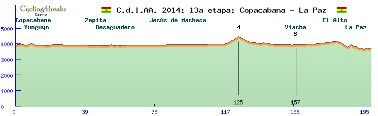
stage type: medium mountain stage
Length: 199 km
hight meters to climb: 1190 m
start of min tact: 21 before finish
duration: 2 h 00 min (including sprint)
categorized mountains:
Kat 4 - 7 km - Ø 6,4% - max. 8%
Now we shift to Bolivia. The transfer is a bit lenghty (about 110 km), but no mountains to cross and good roads, so it should be ok. The start is again at the shores of Lago Titicaca, in Copacabana, from where the road leads back to Peru for a short time, but soon reaches again the bolivian Altiplano. Flat, with the exception of that one mountain (can't call a climb like this a hill), the course reaches El Alto in La Paz. From there, the road leads down to the center of the city, where one steep and one flat hill have to be crossed to reach the finish. The final 20 km are 3, -5, -5, -5, -10, -9, -5, 8, 10, -13, -2, -1, -8, 0, -1, -8, 4, 4, -2, 2. Hope that makes for an interesting finish. After the stage, the teams have to accomplish a very long transfer, but it is completly nessessary.
Stage 14: Caranavi to La Cumbre
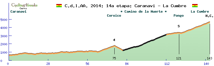
stage type: HC mountain arrival
Length: 143 km
hight meters to climb: 5110 m
start of min tact: 80 before finish
duration: 2 h 02 min (including sprint)
categorized mountains:
Coroico Kat 4 - 11 km - Ø 6,6% - max. 9%
La Cumbre Kat H.C. - 62 km - Ø 5,5% - max. 10%
The highlight of so many Campeonatos can't miss this time, as it has been the 2nd last stage of the first Campeonato as well. It's Death Road time. On a short stage with only the climb to Coroico beeing a short obstacle before the real thing, El Camino de la Muerte will cost the riders everything what they have. Although a new road exist to circumvent it, it's still heavily used to carry goods from the jungle to La Paz and vice versa. Bad road conditions on a slim road, large cliffs to the side. With this lenght and difficulty, it outmatches the other climbs of the tour by such awide margin that is the only one to truly deserves the Haute Catégorie. Well, enjoy the ride!
Stage 15: La Cumbre to La Paz
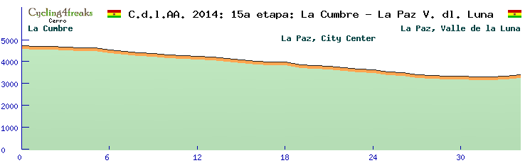
stage type: individual time trail
Length: 34 km
hight meters to climb: 100 m
start of min tact: all
duration: 34 min
A time trail will conclude a tour, but an unusual one. From the pass reached yesterday after the Camino de la Muerte, the course leads downwards to the center of La Paz, and than further down into the Valle de la Luna, where a famous rock formation can be seen. All km apart from the last two are downhill, only those last ones lead upwards. Not all downhill sections are steep, so time trailing skills will play a role as well.
So, that's the Campeonato 2014. Hope you like it. I wish all participants an exiting race and a lot of fun. If you see any mistakes, please be so kind and report to me. Thank you.
Would someone with access to the race database please recheck if everything is uploaded properly?
Some words about the concept headfirst: Does anyone remember the first Campeonato, back in 2006? Back then, all kilometers were ridden in one minute steps, so we had to cut out about 60% of all km to make it work in a senceful timespan. It's also bin the first Campeonato I created, and my first fantasy tour as well, I think. I was not very common with searching appropriate roads. Additionaly, Google Earth did not provide the quality of pictures we are used to now. I guess I had some very imaginative roads in the course. But the resulting profiles were interesting to ride, in my eyes, so I decided it's time to use that general route again, but this time, properly done.
Sure, I did not copy&paste the course of 2006. I don't even have got the files. I just used the same starting point, end point, and as much as I can remember where the stages were and, even more important, what kind of stages they were and their character. Based on this, I created the 2014 Campeonato de los Andes, and this is the result.
Let's start with some general facts and stats. The start is in Lima (Peru), with a prologue, and the Tour finishes in La Paz (Bolivia), with an individual time trail. There are 15 stages and one rest day, so the Tour will start on Saturday and end on Sunday two weeks later. The following two maps show where the stages are. The colors of the stages have the following meaning:
Green - flat stage
Yellow - medium mountain stage
Red - mountain stage
Blue - individual time trail
- Gesamtkarte.jpg (83.19 KiB) Viewed 2283 times
- Detailkarte Cuzco.jpg (105.67 KiB) Viewed 2283 times
The rest day will be after stage 7 in Cuzco, thus on a Saturday.
Every non time trail stage will contain one intermediate sprint and 0 to 5 mountain intermediates, 29 in total. Don't worry if the categories seem to be low, the mountains are hard nevertheless. In order not to overload the tour with intermediates, the mountains have been classified in relative difficulty to each other. As there are some extreme mountains to climb, quite hard ones might end up only getting Category 3 or 4.
The whole tour was created using Google Earth and the Excel editor. Automatic tools were not used, due to the quite often accuring delay of roads, pictures and terrain that would lead to wrong results.Stage 1: Prologue Lima
Stage 1: Prologue Lima
stage type: individual time trail
Length: 11 km
hight meters to climb: 150 m
start of min tact: all
duration: 11 min
For the first stage, in order to present the riders and provide some sort of starting order to the race, a prologue is held in Lima. From the city centre, the race leads down to the coast and later up again to Miraflores, to finish at the Parque de la Reserva. With 11 km, it's quite a long prologue, and not completly flat (with one km at 6%). As none of the time trails in the tour is truely flat, this one might provide the best chances for the specialists to take a stage win.
Stage 2: Lima to Pisco
stage type: flat stage
Length: 231 km
hight meters to climb: 1150 m
start of min tact: 27 before finish
duration: 2 h 19 min (including sprint)
The second stage is a long flat stage and follows the coastline southwards. Nearly al of the stage is on the Panamerica. There is no kilometer steeper than 4%, and due to that, no mountain that was hard enough to earn a categorization. If there are as many sprinters joining the tour as usually, this stage will probably be one for an escaping group.
Stage 3: Laguna Grande to Nazca
stage type: medium mountain stage
Length: 220 km
hight meters to climb: 2060 m
start of min tact: 34 before finish
duration: 2 h 17 min (including sprint)
categorized mountains:
Kat 4 - 14 km - Ø 3,8% - max. 7%
Finally, on the 3rd stage there will be some hills to climb. Most of them are to short to be categorized, but there is one mountain intermediate at a long, but not very steep climb in the first part of the stage. The stage is started near Pisco, and leads further south, but not on the Panamerica. Instead, the track leads away from the coast, but does not enter the Andes yet. The last hill with kilometers steeper than 5% is 27km before the finish in Nazca.
Stage 4: Nazca to Puquoi
stage type: HC mountain stage
Length: 186 km
hight meters to climb: 5160 m
start of min tact: 44 before finish
duration: 2 h 05 min (including sprint)
categorized mountains:
Kat 1 - 43 km - Ø 5,0% - max. 13%
Pampa Galeras Kat 3 - 40 km - Ø 3,8% - max. 6%
Kat 4 - 8 km - Ø 7,9% - max. 11%
There we go, starting at just around 500m, to climb the first pass of nearly 4000m. From Nazca, the course is leading west, straight into the Andes. The first big climb doesn't look too steep if looking at the average percantage, but those include the first 20 km that do not exceed 5%. The rest of climb is much steeper, making it one of the 4 hardest climbes of the tour. After a short flat passage and downhill, the rest of the climb to the national park of Pampa Galeras has to be climbed, which is not nearly as steep as the Kat 1. A very important climb will be the Kat 4 - mountain. From there, it's 6 quite flat km and 6km downhill to the last kilometer, which is at 5%. That might hurt some cooperations on the kilometers from the last mountain, as some time differences may occur here. A quite demanding start for the climbers, and there's more to come just the next day.
Stage 5: Chipoa to Querobamba
stage type: HC mountain arrival
Length: 219 km
hight meters to climb: 5320 m
start of min tact: 53 before finish
duration: 2 h 26 min (including sprint)
categorized mountains:
Kat 3 - 31 km - Ø 4,0% - max. 8%
Kat 4 - 11 km - Ø 6,5% - max. 9%
Kat 2 - 17 km - Ø 7,1% - max. 10%
The second HC stage is the first mountain arrivel of the tour. After a transfer of about 60 km, the stage starts in Chipoa, immediatly beginnig the first climb of the day. After a short downhill and another short climb, one of the typical high plains has to be crossed. Staying on the same level nearly, there are quite some ups and downs that won't make it to easy for the riders. After a long downhill, splitted by another climb, the riders arrive at the final climb. As it is a long and difficult one, expect quite some time differentials to occur.
Stage 6: Pomacocha to Andahuaylas
stage type: HC mountain stage
Length: 226 km
hight meters to climb: 5460 m
start of min tact: 57 before finish
duration: 2 h 32 min (including sprint)
categorized mountains:
Kat 4 - 14 km - Ø 5,6% - max. 8%
Kat 1 - 28 km - Ø 6,3% - max. 10%
Abra Sotacocha Kat 4 - 22 km - Ø 4,4% - max. 6%
Aeropuerto de Andahuaylas Kat 4 - 14 km - Ø 4,6% - max. 8%
Kat 3 - 8 km - Ø 9,8% - max. 12%
Another transfer of about 70 km leads the riders to the start of the next stage. Crossing the Andes in one of their widest areas, there's not much room but to ad another difficult stage. This time, there are not a lot of flat km, as the race is mostly up and down. Starting with a smaller mountain of only 14 km in length, a long descend follows to the lowest point of the day. Here starts the 2nd of just 3 Kat 1 mountains, so it's a very tough one. A short downhil and a less steep climb to Abra Sotacocha is followed by the descent to Andahuaylas, from where another 2 mountains have to be climbed. The last one may be short, but features the highest average percentage of all climbs of the tour. Pay attention to the 2 steep km that follow after a short downhill, as they are 6% and 8% as well. Due to it's lenght and the number of climbs, this might be the most difficult stage for the grupetto.
Stage 7: Abancay to Cuzco
stage type: HC mountain stage
Length: 191 km
hight meters to climb: 3960 m
start of min tact: 25 before finish
duration: 1 h 58 min (including sprint)
categorized mountains:
Abra Soraqasa Kat 2 - 36 km - Ø 4,5% - max. 7%
Abra Arcopunco Kat 2 - 42 km - Ø 4,4% - max. 6%
And yet again, another HC stage. But this time, the character is completly different. Starting in Abancay (transfer of 50 km approximatly), Abra Soraqasa and Abra Arcopunco have to be climbed. Both are very similar climbs: Long, but not very steep. After Abra Arcopunco, no kilometer is exceeding 5%. Thus, this is probably not a stage for climbers. Yet, nearly 4000 hm clearly show that this is a very demanding stage nevertheless.
after Stage 7: Rest day (Saturday)
After those difficult stages, the riders really deserve this one. Yet, they are not completly free of tasks, as they have to do a transfer to the peruanian jungle (approximatly 250 km), in order to start next days stage.
Stage 8: Pilcopata to Catsa
stage type: HC mountain stage
Length: 179 km
hight meters to climb: 4470 m
start of min tact: 28 before finish
duration: 1 h 54 min (including sprint)
categorized mountains:
Puesto de Vigilancia Acjanaco Kat 1 - 80 km - Ø 3,1% - max. 7%
Kat 4 - 59 km - Ø 2,3% - max. 5%
Well, what may a Campeonato stage look like after a transfer deep down to the yungle? Sure, a hard mountain stage with a long climb in the start hast to follow. Don't let you trick by the low average percentage, there's also a longer part of 6 and 7% kilometers. But overall, it's clearly the lenght that gets it category 1. After the summit, no upwards kilometer is steeper than 5%. Thus, the race is more suited to classic riders than to mountain specialists. GC candidates may try to hold back anyway, as they need their power the coming day.
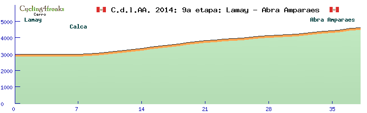
Stage 9: Lamay to Abra Amparaes
stage type: Individual time trail
Length: 38 km
hight meters to climb: 1620 m
start of min tact: all
duration: 38 min
Like in 2006, a long mountain time trail with a few flat kilometers at the start will be a part of the tour. The first 8 km are flat, but the climb to Abra Amparaes with 30 km of an average of 5,3% and a maximum of 8% clearly dominates the time trail.
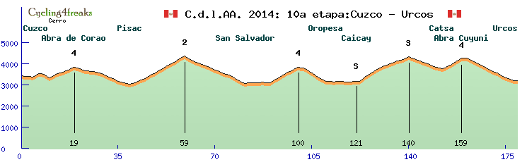
Stage 10: Cuzco to Ucros
stage type: HC mountain stage
Length: 179 km
hight meters to climb: 4580 m
start of min tact: 59 before finish
duration: 2 h 09 min (including sprint)
categorized mountains:
Abra de Corao Kat 4 - 9 km - Ø 5,8% - max. 8%
Kat 2 - 20 km - Ø 6,7% - max. 9%
Kat 4 - 10 km - Ø 7,2% - max. 9%
Kat 3 - 18 km - Ø 6,5% - max. 10%
Abra Cuyuni Kat 4 - 7 km - Ø 7,0% - max. 8%
After 4 days, it's time again to have a stage for real climbers. With 5 categorized mountains, it's tied for most in the tour with stage 6. Directly from Cuzco, the Abra de Corao hast to be climbed to reach the Valle Sagrada. From here, the track goes up left, right and left from the valley for the next 3 climbes, in general direction southeast. The 4th climb is a quite important one, as the first part is the steepest section of the day (7 km of 8,5% in average). After that summit, the stage reaches the track of stage 8, but turns right just in front of stage 8's finish to climb Abra Cuyuni and to go back to the Valle Sagrada with the finish in Ucros.
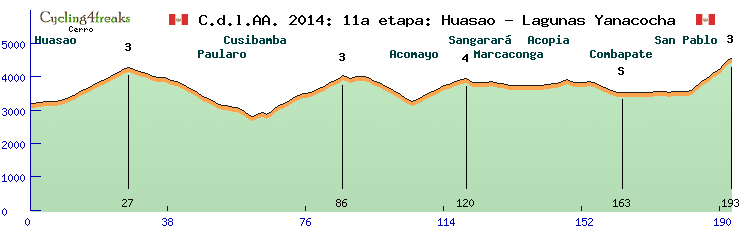
Stage 11: Cuzco to Ucros
stage type: HC mountain arrival
Length: 193 km
hight meters to climb: 4380 m
start of min tact: 13 before finish
duration: 1 h 53 min (including sprint)
categorized mountains:
Kat 3 - 17 km - Ø 5,6% - max. 8%
Kat 3 - 21 km - Ø 5,7% - max. 11%
Kat 4 - 14 km - Ø 4,9% - max. 7%
Lagunas Yanacocha Kat 3 - 11 km - Ø 8,6% - max. 12%
Another hard mountain stage (don't worry, the last one of this row). This time, it's a mountain arrival. The stage leads southeast quite directly. After a hard up and down of 3 climbs, the profile levels out a bit, while pasing the lakes Laguna Pomacanchi and Laguna Asnacocha. After the downhill to the main valley, some more flat kilometers follow to the beginning of the not very long, but steep final climb. A good chance for climbers to gain somte time in GC.
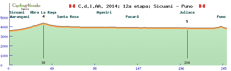
Stage 12: Sicuani to Puno
stage type: flat stage
Length: 249 km
hight meters to climb: 1190 m
start of min tact: 31 before finish
duration: 2 h 30 min (including sprint)
categorized mountains:
Abra la Raya Kat 4 - 39 km - Ø 2,3% - max. 5%
After a short transfer, we just follow the valley this time. A long flat stage headfirst leads up to Abra la Raya, but that one is nothing close to what the riders have been used to. The course leads straight souteast, with very few turns, to reach the Altiplano. The little hill right before Puno has a maximum percentage of 4, the downhill down to the shores of Lago Titicaca is just a bit steeper. The last hill might provide some interesting possibilities for the fight for the stage win of the group that supposably will win that stage.
Stage 13: Copacabana to La Paz
stage type: medium mountain stage
Length: 199 km
hight meters to climb: 1190 m
start of min tact: 21 before finish
duration: 2 h 00 min (including sprint)
categorized mountains:
Kat 4 - 7 km - Ø 6,4% - max. 8%
Now we shift to Bolivia. The transfer is a bit lenghty (about 110 km), but no mountains to cross and good roads, so it should be ok. The start is again at the shores of Lago Titicaca, in Copacabana, from where the road leads back to Peru for a short time, but soon reaches again the bolivian Altiplano. Flat, with the exception of that one mountain (can't call a climb like this a hill), the course reaches El Alto in La Paz. From there, the road leads down to the center of the city, where one steep and one flat hill have to be crossed to reach the finish. The final 20 km are 3, -5, -5, -5, -10, -9, -5, 8, 10, -13, -2, -1, -8, 0, -1, -8, 4, 4, -2, 2. Hope that makes for an interesting finish. After the stage, the teams have to accomplish a very long transfer, but it is completly nessessary.
Stage 14: Caranavi to La Cumbre
stage type: HC mountain arrival
Length: 143 km
hight meters to climb: 5110 m
start of min tact: 80 before finish
duration: 2 h 02 min (including sprint)
categorized mountains:
Coroico Kat 4 - 11 km - Ø 6,6% - max. 9%
La Cumbre Kat H.C. - 62 km - Ø 5,5% - max. 10%
The highlight of so many Campeonatos can't miss this time, as it has been the 2nd last stage of the first Campeonato as well. It's Death Road time. On a short stage with only the climb to Coroico beeing a short obstacle before the real thing, El Camino de la Muerte will cost the riders everything what they have. Although a new road exist to circumvent it, it's still heavily used to carry goods from the jungle to La Paz and vice versa. Bad road conditions on a slim road, large cliffs to the side. With this lenght and difficulty, it outmatches the other climbs of the tour by such awide margin that is the only one to truly deserves the Haute Catégorie. Well, enjoy the ride!
Stage 15: La Cumbre to La Paz
stage type: individual time trail
Length: 34 km
hight meters to climb: 100 m
start of min tact: all
duration: 34 min
A time trail will conclude a tour, but an unusual one. From the pass reached yesterday after the Camino de la Muerte, the course leads downwards to the center of La Paz, and than further down into the Valle de la Luna, where a famous rock formation can be seen. All km apart from the last two are downhill, only those last ones lead upwards. Not all downhill sections are steep, so time trailing skills will play a role as well.
So, that's the Campeonato 2014. Hope you like it. I wish all participants an exiting race and a lot of fun. If you see any mistakes, please be so kind and report to me. Thank you.
Would someone with access to the race database please recheck if everything is uploaded properly?
-
Cerro Torre RT
- Posts: 578
- Joined: Wed Feb 17, 2010 2:44 pm
- Contact:
Re: Campeonato de los Andes 2014
And something I've forgotten: For those interested in the exact path, here's the exported data from Google Earth (.kml)
- Attachments
-
- Campeonato 2014.zip
- (340.77 KiB) Downloaded 136 times
Who is online
Users browsing this forum: No registered users and 4 guests