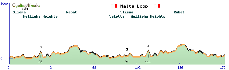
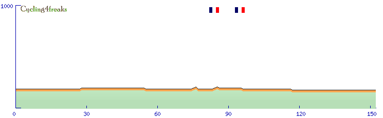
Got to say something to your race today at the Sexchelles... cause from what I saw in Google Earth, your profile was quite wrong. As there's only one mountain at the Seychelles that more than 700m high, it's obvious where your sttep climb was, and what was wrong with it. The clouds do not allow to see the street in total, but what is obvious is that it doesn't follow that yellow line symbolising the street (could imagine that's what displayed in google maps, but don't know). From the beginning of the cloud, the line just goes straight over the mountain, but in a hole in the the clouds you can see the street, quite far left from the line, crossing the range at just 550 meters or something like that. So I don't know how you made that race, but if you see a road that steep, you should check and think about if this could really be. Especially if the road goes perfectly straight, with 20% climbs. I haven't seen something like that anywhere in Google Earth till now. The mountain today was just heavily wrong.
And by the way, your tour de Guadaloupe, Puerto Rico, Split Biokovo and Uganda look weird, maybe similar mistakes happend there. Those ups and downs in climbes are unusal, that's not the way roads are build normally. I suppose your method is not quite good to make those races. When I made my race around the Gorges du Verdon, I saw the white and yellow road lines and even the picture just going down 300m nearly vertical drop into the cataract, and after a curve directly out again. Which is wrong clearly, I just corrected that by imagining how tha road might probably lead correctly. Checking those climbes with Googel Earht might help here.
Woddelton Creation Team
Moderators: systemmods, Calendarmods
-
Mapei Quickstep
- Posts: 77
- Joined: Sat Oct 15, 2011 11:45 pm
- Contact:
-
Woddeltown Team
- Posts: 413
- Joined: Sat Aug 06, 2011 6:46 pm
- Contact:
Re: Woddelton Creation Team
Actually i like sexchelles 
Seriously, i can't even recognize it, because i haven't got the tcx-files for now.
But the main problem for those countries or islands like Seychelles or Guadeloupe is, that the street maps are not that correct than in reality. That is basicly a problem of T4B or maybe of my GPS-program. Don't know exactly.
Especially for Seychelles: the road (called chemin sanssouci) with the steps is going up to 800+ metres. So the level is right and i guess the the slopes. I check it at the moment at T4B: from the beginning at Independence Avenue to the highest point its a step from 33m above sea level to 800m in round about four km and then the street goes down to sea level or nearby in round about four to five km. So the question is: where is the problem?
So if you think that the mountain is not correct at all, then check it on your own.
Another problem is, that the editor allows only 20%-slopes up and down. If there is a kilometre with a slope of 30% for example, you will have two oppurtunies: you cut the the slopes of 10%, so the level is 100m lower or higher. Or you try to put in the 10% on other kilometres.
Next problem: you see the building of streets from an european point of view. Yes, we are not building roads with slopes up to 30% percent or something because we are building tunnels or other buildings to cut the slopes. In Africa or India for example, the streets are build up with this high sloves. Not everywhere, but often enough.
A word to Split Biokovo: i don't know if you have ever been there, but i was there two times, two times on this mountain called sveti jure. And i suggest, that this slopes are as high as i expected in the race. If you drive the street (someone will call it path ) it is that hard.
Finally a last word: these are fantasy races and i guess, that something is partly not as correct as it might be in reality. And if someone is not agreeing with a fantasy race, he should not ride it! Also:
P.S.: Warum schreibst du mir das eigentlich in Englisch`?
Seriously, i can't even recognize it, because i haven't got the tcx-files for now.
But the main problem for those countries or islands like Seychelles or Guadeloupe is, that the street maps are not that correct than in reality. That is basicly a problem of T4B or maybe of my GPS-program. Don't know exactly.
Especially for Seychelles: the road (called chemin sanssouci) with the steps is going up to 800+ metres. So the level is right and i guess the the slopes. I check it at the moment at T4B: from the beginning at Independence Avenue to the highest point its a step from 33m above sea level to 800m in round about four km and then the street goes down to sea level or nearby in round about four to five km. So the question is: where is the problem?
So if you think that the mountain is not correct at all, then check it on your own.
Another problem is, that the editor allows only 20%-slopes up and down. If there is a kilometre with a slope of 30% for example, you will have two oppurtunies: you cut the the slopes of 10%, so the level is 100m lower or higher. Or you try to put in the 10% on other kilometres.
Next problem: you see the building of streets from an european point of view. Yes, we are not building roads with slopes up to 30% percent or something because we are building tunnels or other buildings to cut the slopes. In Africa or India for example, the streets are build up with this high sloves. Not everywhere, but often enough.
A word to Split Biokovo: i don't know if you have ever been there, but i was there two times, two times on this mountain called sveti jure. And i suggest, that this slopes are as high as i expected in the race. If you drive the street (someone will call it path
Finally a last word: these are fantasy races and i guess, that something is partly not as correct as it might be in reality. And if someone is not agreeing with a fantasy race, he should not ride it! Also:
in my opinion this is not the correct way to do something, because sometimes it seems higher or lower than it is in reality.I just corrected that by imagining
P.S.: Warum schreibst du mir das eigentlich in Englisch`?
www.strandpiraten-radio.de DAS Fanradio vom EHC Timmendorfer Strand
Re: Woddelton Creation Team
Agree with Mapei!
tracks4bikers in many places just isn't that reliable. In many places meaning basically: Exotic countries. So everything outside north america, Europe, maybe Japan/Australia/NZL. Use all the resources available. t4b of course is the most easy to use, but if you have high percentages, or saws (up down up down up down with something like 20 -5 20 -10 etc) don't just believe it but check.
- always check satellite view: do you actually SEE the road? Here it's cloudy.
- always check "Gelände": Does the road make any sense? Here it doesn't, nothing to do with European vs African point of view, it just doesn't make any sense. curves in the beginning, then straight, curves in the end. And remembering what we saw in the satellite view we remember that the straight is where the clouds are.. mmh, why could that be?
- check google earth, check older satellite images, sometimes the clouds are not there in older satellite images, then can you see the road? Don't know, google earth not working anymore here, sniff)
- check t4b OSM build. It has less roads, yep, sometimes the automatic tracking doesn't work even if there are roads, but sometimes they do. Here the road is there and the tracking works and... surprise, the road looks much different.
With the GMAP builder you get something like:
9-10-39-21 for the climb
-35-10-13-12-8 downhill.
With the OSM builder you get:
6-10-6-0-10-8-6 (in 600 meters 60 meters up.. doesn't fit the top, then just do the start 400 meters earlier so it fits, not going to do that, ah yes I will... 4-8-8-4-5-9-10) top at 480 or so meters. And I dare say that's what is is in reality.
- check satellite view in OSM build too: Here the road goes through the clouds as well, but each time they are not there, you see a road. A few meters to the side, so not completely correct either very likely. (but could be the image that is wrong too...) In those cases if it's important enough, do it by hand, not automatic tracking, to follow the road exactly.
- check "gelände" view in OSM build too. Does the road make any sense? Here it does, it actually passes through the pass, the 900 meters high mountain to the west, the 560 high on in the east, takes the lowest point in between them. Again, nothing to do with European and African points of view.
- check wikipedia just to check. Maps, infos. Maps here helps, there is a map, where the road looks like the one on the OSM builder
- check http://www.lib.utexas.edu/maps/ for maps. Of course that doesn't help much or at all if you design in Russia.. to big, but for the Seychelles, Guadeloupe etc... if there are doubts about the road (which you seem not to have, but should have if you see 30+ percentages straigt roads) it can give an idea. The map on wikipedia very likely comes from there.
- check panoramio, see if there are pictures along the road, of the road, sometimes that helps. Here couldn't find any.
- check websites about the country. tourism websites, Websites by people who travelled or work there. Sometimes there is a map, if there is a road going close to the highest point of the island (like you claim) maybe there is a mention of that.
Takes longer, yes. But gives better profiles that reflect reality better. Fantasy races not so important... yes, but still no reason not to try to make them as precise as possible. If you don't like it, don't ride it, well, hard if you are an addict... it's the only one day race offered. But ok, not a big problem in fantasy races, but in real races, a big problem.
Kraftsystemrevision! Include the distance!
Basics reform: Give blue a chance!
Don't punish bugusers. We all have to use bugs, since most of them are declared as "features"!
Got a carrot from FL. But they threaten to take it away now.
Basics reform: Give blue a chance!
Don't punish bugusers. We all have to use bugs, since most of them are declared as "features"!
Got a carrot from FL. But they threaten to take it away now.
Re: Woddelton Creation Team
Ah, had to look at Guadeloupe and Uganda and Puerto Rico too.. No idea about Guadeloupe, although that last climb seems a bit steep.
Question about Uganda though? Bujumbura? Last time I checked that's the capital of Burundi. Ok, maybe there is a Bujumbura in Uganda too... wait, 2 Bujumburas, since you have 2 Sprints in Bujumbura at different altitudes! ok, posssible, but really wondering if it's Uganda or Burundi now..
Question about Uganda though? Bujumbura? Last time I checked that's the capital of Burundi. Ok, maybe there is a Bujumbura in Uganda too... wait, 2 Bujumburas, since you have 2 Sprints in Bujumbura at different altitudes!
Kraftsystemrevision! Include the distance!
Basics reform: Give blue a chance!
Don't punish bugusers. We all have to use bugs, since most of them are declared as "features"!
Got a carrot from FL. But they threaten to take it away now.
Basics reform: Give blue a chance!
Don't punish bugusers. We all have to use bugs, since most of them are declared as "features"!
Got a carrot from FL. But they threaten to take it away now.
-
Woddeltown Team
- Posts: 413
- Joined: Sat Aug 06, 2011 6:46 pm
- Contact:
Re: Woddelton Creation Team
Holy crab...what a mistakeRobyklebt wrote:Ah, had to look at Guadeloupe and Uganda and Puerto Rico too.. No idea about Guadeloupe, although that last climb seems a bit steep.
Question about Uganda though? Bujumbura? Last time I checked that's the capital of Burundi. Ok, maybe there is a Bujumbura in Uganda too... wait, 2 Bujumburas, since you have 2 Sprints in Bujumbura at different altitudes!
the two differrent altitudes..one at sea level of Tanganjika lake, one at the beginning of the mountains...maybe the 2nd sprint could be renamed.
to the other problem: you can be sure that i check it with Gelände, GM it self and Google Earth, if i paint real races i check it with OSM-Builder if possible and with the cards and informations i can get by the organizer. And especially in Germany or Holland i ask people coming out of this area or remember myself being there.
But: in Fantasy races i didn't see this a problem as big as you see. And i don't get your opinion of the clouds. Because of the clouds on Google Earth the street is noch that high as you expected?
www.strandpiraten-radio.de DAS Fanradio vom EHC Timmendorfer Strand
Re: Woddelton Creation Team
No, because of clouds you can't see the road. So you don't know if it actually passes through were google maps and earth show with their yellow lines. There the question is always, is that where the road passes or just a wild guess? Here it looks clearly like a wild guess... as long as you see the road it's never even close to 20%, and lots of curves. Once it disappears under the clouds and you only see the yellow line, it becomes straight and climbs at way over 20%...
So the point of the clouds is: When there are clouds you don't see the road directly. And don't trust the yellow lines too much..
So the point of the clouds is: When there are clouds you don't see the road directly. And don't trust the yellow lines too much..
Kraftsystemrevision! Include the distance!
Basics reform: Give blue a chance!
Don't punish bugusers. We all have to use bugs, since most of them are declared as "features"!
Got a carrot from FL. But they threaten to take it away now.
Basics reform: Give blue a chance!
Don't punish bugusers. We all have to use bugs, since most of them are declared as "features"!
Got a carrot from FL. But they threaten to take it away now.
-
Woddeltown Team
- Posts: 413
- Joined: Sat Aug 06, 2011 6:46 pm
- Contact:
Re: Woddelton Creation Team
In Memoriam Vaclav Havel, maybe for December 27th
Start at the town where he died several days ago and the route is crossing to Praha. At Praha a last sprint at Wenceslas Square (German Wenzelsplatz) and a crossing on the other Moldau side. Crossing the Charles Bridge (Karlsbrücke) could be selective because of its paves and then the last kilometres back to Wenceslas Square.

Start at the town where he died several days ago and the route is crossing to Praha. At Praha a last sprint at Wenceslas Square (German Wenzelsplatz) and a crossing on the other Moldau side. Crossing the Charles Bridge (Karlsbrücke) could be selective because of its paves and then the last kilometres back to Wenceslas Square.
www.strandpiraten-radio.de DAS Fanradio vom EHC Timmendorfer Strand
-
Rockstar Inc
- Posts: 1915
- Joined: Thu Feb 18, 2010 10:15 pm
- Location: Norimberga
- Contact:
Re: Woddelton Creation Team
[quote="Woddeltown Team"]In Memoriam Vaclav Havel, maybe for December 27th
Start at the town where he died several days ago and the route is crossing to Praha. At Praha a last sprint at Wenceslas Square (German Wenzelsplatz) and a crossing on the other Moldau side. Crossing the Charles Bridge (Karlsbrücke) could be selective because of its paves and then the last kilometres back to Wenceslas Square.
[/quote
1st)wrong date...27th will be the anniversary race
2nd)fuck off politics ingame
Start at the town where he died several days ago and the route is crossing to Praha. At Praha a last sprint at Wenceslas Square (German Wenzelsplatz) and a crossing on the other Moldau side. Crossing the Charles Bridge (Karlsbrücke) could be selective because of its paves and then the last kilometres back to Wenceslas Square.
[/quote1st)wrong date...27th will be the anniversary race
2nd)fuck off politics ingame
"I'm an old-school sprinter. I can't climb a mountain but if I am in front with 200 metres to go then there's nobody who can beat me.” Mark Cavendish, at the 2007 Eneco Tour
Re: Woddelton Creation Team
For me OK, but not necessary at 27th. For me more historical than political , but everybody can think as he want.Woddeltown Team wrote:In Memoriam Vaclav Havel, ....
-
Woddeltown Team
- Posts: 413
- Joined: Sat Aug 06, 2011 6:46 pm
- Contact:

-
Woddeltown Team
- Posts: 413
- Joined: Sat Aug 06, 2011 6:46 pm
- Contact:

-
Woddeltown Team
- Posts: 413
- Joined: Sat Aug 06, 2011 6:46 pm
- Contact:

-
Woddeltown Team
- Posts: 413
- Joined: Sat Aug 06, 2011 6:46 pm
- Contact:
Re: Woddelton Creation Team
A Shourt tour in Sri Lanka


www.strandpiraten-radio.de DAS Fanradio vom EHC Timmendorfer Strand
-
Woddeltown Team
- Posts: 413
- Joined: Sat Aug 06, 2011 6:46 pm
- Contact:
Re: Woddelton Creation Team
Binter Canaris...Tour with stages on all bigger Canary Islands


www.strandpiraten-radio.de DAS Fanradio vom EHC Timmendorfer Strand
-
Woddeltown Team
- Posts: 413
- Joined: Sat Aug 06, 2011 6:46 pm
- Contact:
-
Woddeltown Team
- Posts: 413
- Joined: Sat Aug 06, 2011 6:46 pm
- Contact:
-
Woddeltown Team
- Posts: 413
- Joined: Sat Aug 06, 2011 6:46 pm
- Contact:
-
Woddeltown Team
- Posts: 413
- Joined: Sat Aug 06, 2011 6:46 pm
- Contact:
-
Woddeltown Team
- Posts: 413
- Joined: Sat Aug 06, 2011 6:46 pm
- Contact:
-
Woddeltown Team
- Posts: 413
- Joined: Sat Aug 06, 2011 6:46 pm
- Contact:
Re: Woddelton Creation Team
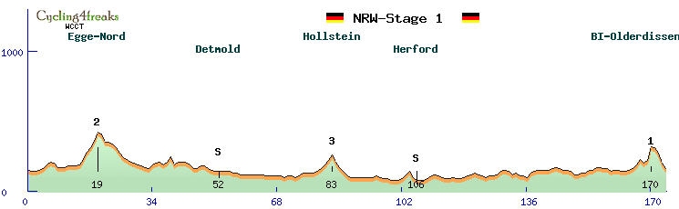
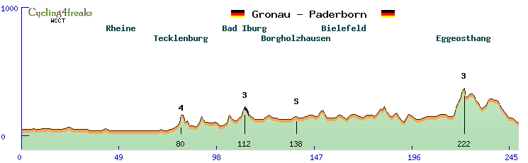
NRW-Tour 2012 starting @ Paderborn in the East of Westfalia. Directing to the NorthWest it is crossing the conservation area of Egge-Nord with a 1st climb.
After that it will be coming flatter and the track is directing via Detmold and Bad Salzuflen to Herford. A last loop in the North and we are going back to south to the City of Bielefeld - the City that doesn't exist
We are crossing through town before going to Olderdissen and have a last Climb at the easternmost Part of the Teutoburger Wald.
Egge-Nord: 4/5/3/5/6
Hollstein: 1/2/3/3/4
Bielefeld-Olderdissen (also last 10): 1/3/4/-3/2/10/-1/-4/-7/-4
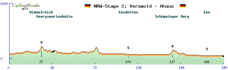
An easy stage beginning at Versmold. Directing to the North we are going to Georgsmarienhütte with a little pave. We are going along the border of NRW and Lower Saxony to Emsdetten and then very straight to the Finish in Ahaus. But we will do two loops to the Schöppinger Berg (known from last year) and to Epe for a last sprint. The finish is in the pedestrian precinct of Ahaus, so we have a pave
Himmelreich: 1/1/4/5
Schöppinger Berg: 1/2/5
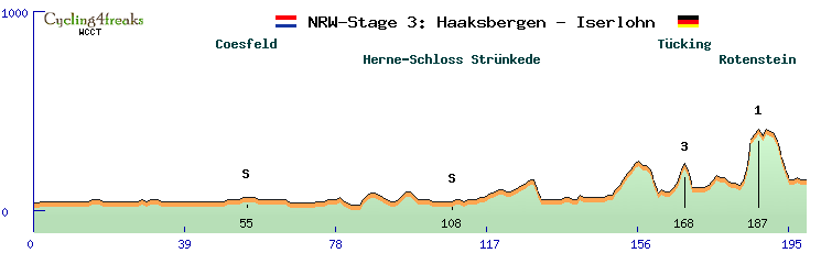
We are starting the third stage in the Netherlands, but after several kilometres we are back in Germany. Directing to Southeast, South we are crossing Stadtlohn - Coesfeld - Haltern am See - Recklinghausen and joining the Ruhr. Maybe we can have a little coffee at Leso before going to the sprint at Schloss Strünkede. Going on to the south, crossing Bochum, Witten and Lake Kemnade. Then we going to the "Bergisches Land" and it will become hilly. 14km before finish we climb to the Rotenstein and then going down to the City of Iserlohn.
Tücking: 2/2/7/3
Rotenstein : 2/8/13/3/2
last 10: -1/-1/-5/-7/-7/-4/0/1/-1/0
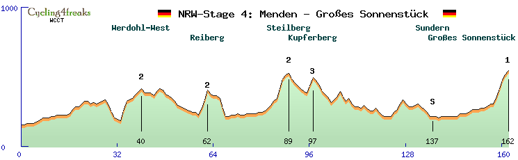
A last very hilly Stage in the Sauerland. Starting at Menden the stage is going through the Lennegebirge to Werdohl and to the West to Lüdenscheid. We are going around and via Plettenberg we ware going to Eslohe. Short before Eslohe we are directing to the North to Balve and via Sundern to our Finish on the "Großes Sonnenstück"-Hill.
Werdohl-West: 7/7/1/1/3/2/2
Reiberg: 5/6/7
Steilberg: 2/2/3/2/7/7/3/1
Kupferberg; 5/6
Großes Sonnenstück (last 10): 1/0/1/2/0/4/7/6/4/3
www.strandpiraten-radio.de DAS Fanradio vom EHC Timmendorfer Strand
-
Woddeltown Team
- Posts: 413
- Joined: Sat Aug 06, 2011 6:46 pm
- Contact:
Re: Woddelton Creation Team
of courseWoddeltown Team wrote:[
Maybe we can have a little coffee at Leso before going to the sprint at Schloss Strünkede.
The sprint winner get also a "leckere Bratwurst" from my BBQ.
-
Woddeltown Team
- Posts: 413
- Joined: Sat Aug 06, 2011 6:46 pm
- Contact:
-
Woddeltown Team
- Posts: 413
- Joined: Sat Aug 06, 2011 6:46 pm
- Contact:
-
Woddeltown Team
- Posts: 413
- Joined: Sat Aug 06, 2011 6:46 pm
- Contact:
Who is online
Users browsing this forum: No registered users and 26 guests