Start of the world tour...and if the races in Canada, romandy or catalunya get Cat 4 imo Tour Down Under should also get this category...but ok....same cat then tirreno or paris-nice...hmm...also a downgrade of stuff like romandy or catalunya possible...
or making a complete new "category" system based on the uci-cats...f.e. 1.2 or 2.1 or 1.HC...but also not sure about that...
edit: i didn't meant to give races cats like 1.2 or 2.1...just these numbers as possible orientation for the rsf-cats...i know we use them already, but as far as i know leso uses or used an older overview?
January 2013
Moderators: systemmods, Calendarmods
-
Rockstar Inc
- Posts: 1914
- Joined: Thu Feb 18, 2010 10:15 pm
- Location: Norimberga
- Contact:
Re: January 2013
"I'm an old-school sprinter. I can't climb a mountain but if I am in front with 200 metres to go then there's nobody who can beat me.” Mark Cavendish, at the 2007 Eneco Tour
Re: January 2013
IMO Cat 3 is still enough for the lesser world tour stage races. Down Under, Poland, Eneco, Beijing and whatever other chinese shit the UCI comes up with.
They still are nowhere near the prestige of the traditional stage races. Including Romandie and Catalunya.
They still are nowhere near the prestige of the traditional stage races. Including Romandie and Catalunya.
Kraftsystemrevision! Include the distance!
Basics reform: Give blue a chance!
Don't punish bugusers. We all have to use bugs, since most of them are declared as "features"!
Got a carrot from FL. But they threaten to take it away now.
Basics reform: Give blue a chance!
Don't punish bugusers. We all have to use bugs, since most of them are declared as "features"!
Got a carrot from FL. But they threaten to take it away now.
-
Pokemon Club

- Posts: 3217
- Joined: Mon Oct 17, 2011 1:37 pm
- Contact:
Re: January 2013
hum Jelisco is the only parallel tour at EAT ?

Re: January 2013
For the moment there is nothing for classic riders..few one day races only , and from 7january to 13 there is no tour exept EAT , puting Levantine Shores tour (fantasy by Radunion) from 7 to 13 of or Vuelta Ecuador (made by Taka ) on this date too would be great since teams with classic riders only are just tourists in the curent tours/one day races..
Re: January 2013
The TDU still looks bad.sylvainmeteo wrote:BTW it's exactly the same stage as last year, you can take mineNoPikouze wrote:As far as I can see the TDU profile is not perfect. Especially the 2 willunga hills from stage 5 !
Great innovation this automatic design... but has to be used with caution
151,5 km like last year...
Hunsrueck's willunga hill : 2/6/8/6/5
SM Team's willunga hill : 2/3/8/7/6
Roby help us ^^
@Hunsrueck: Do you want to change it yourself or do you need support?
Re: January 2013
Sorry, but I do not find the error.Alkworld wrote:The TDU still looks bad.sylvainmeteo wrote:BTW it's exactly the same stage as last year, you can take mineNoPikouze wrote:As far as I can see the TDU profile is not perfect. Especially the 2 willunga hills from stage 5 !
Great innovation this automatic design... but has to be used with caution
151,5 km like last year...
Hunsrueck's willunga hill : 2/6/8/6/5
SM Team's willunga hill : 2/3/8/7/6
Roby help us ^^
@Hunsrueck: Do you want to change it yourself or do you need support?
The stage is the same as last year, so we can take the stage from SM.
Come with the round courses not so clear 100%
If you want to even check times, the stage is stored in: tdust5.c4f
Thanks and sorry
Re: January 2013
I changed it a little bit. I adjusted the elevation of the two Willunga hill laps in the race to the elevations calculated with the coordinates (don't know if they are correct however). I ended up with 6-8-7-5, which is still pretty close to Hunsrueck's original version. The -12 downhill was a bit shocking, don't know where that came from.Hunsrueck wrote:Sorry, but I do not find the error.
The stage is the same as last year, so we can take the stage from SM.
Come with the round courses not so clear 100%
If you want to even check times, the stage is stored in: tdust5.c4f
Thanks and sorry

http://www.radsportfreaks.de/radsport/p ... ension=c4f
Re: January 2013
Stage 6 also doesn't look good. It's a 4,5km circuit (difficult in RSF of course), so you can make it either 4 or 5 km, but it definitely doesn't end uphill and the laps should always be the same.Hunsrueck wrote:Stage 6
MinTact: Km 60
LastKm: 0/0/0/1/1
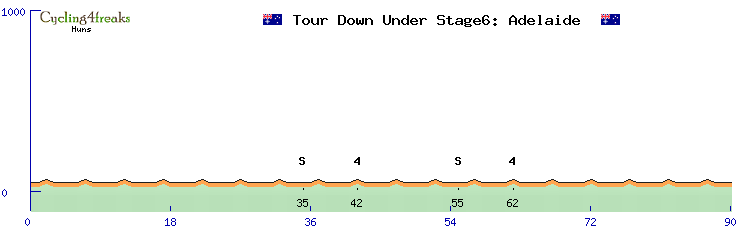
And another thing: The small climb of the lap itself is pretty short, but quite steep in real life (the corner of Montefiore Rd and Strangways Tce is the highest point, it's quite a bit above the Adelaide Oval on War Memorial Drive (see http://www.touradelaide.com/images/adel ... ne_600.jpg)). 2% might be more realistic here, but I don't know the correct altitudes.
Re: January 2013
Any opinions about that? Should I change it or not? The least what there's to correct would be making the circuit an actual circuit.Alkworld wrote:Stage 6 also doesn't look good. It's a 4,5km circuit (difficult in RSF of course), so you can make it either 4 or 5 km, but it definitely doesn't end uphill and the laps should always be the same.Hunsrueck wrote:Stage 6
MinTact: Km 60
LastKm: 0/0/0/1/1
And another thing: The small climb of the lap itself is pretty short, but quite steep in real life (the corner of Montefiore Rd and Strangways Tce is the highest point, it's quite a bit above the Adelaide Oval on War Memorial Drive (see http://www.touradelaide.com/images/adel ... ne_600.jpg)). 2% might be more realistic here, but I don't know the correct altitudes.
Re: January 2013
http://www.radsportfreaks.de/radsport/p ... ension=c4f

http://www.radsportfreaks.de/radsport/p ... ension=c4f
http://www.radsportfreaks.de/radsport/p ... ension=c4f
http://www.radsportfreaks.de/radsport/p ... ension=c4f

http://www.radsportfreaks.de/radsport/p ... ension=c4f
http://www.radsportfreaks.de/radsport/p ... ension=c4f
final circuits will be corrected.
Re: January 2013
I changed it, circuit is now 0/2/-2/0/0Alkworld wrote:Stage 6 also doesn't look good. It's a 4,5km circuit (difficult in RSF of course), so you can make it either 4 or 5 km, but it definitely doesn't end uphill and the laps should always be the same.Hunsrueck wrote:Stage 6
MinTact: Km 60
LastKm: 0/0/0/1/1
And another thing: The small climb of the lap itself is pretty short, but quite steep in real life (the corner of Montefiore Rd and Strangways Tce is the highest point, it's quite a bit above the Adelaide Oval on War Memorial Drive (see http://www.touradelaide.com/images/adel ... ne_600.jpg)). 2% might be more realistic here, but I don't know the correct altitudes.
-
NicoVanarlo
- Posts: 718
- Joined: Mon Jun 13, 2011 9:49 pm
- Contact:
Re: January 2013
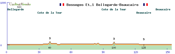
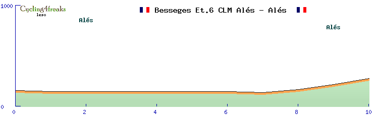
http://www.etoiledebesseges.com/images/ ... rcours.pdflesossies wrote: Besseges2 ???
http://www.etoiledebesseges.com/images/ ... 0Carte.pdf
I don't have the time to draw it, just post the link

Re: January 2013
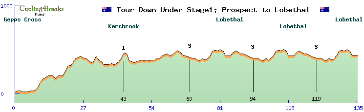
@leso: Can you pls update the profiles of the Tour Down Under? Three stages (1, 5 and 6) were corrected.
Re: January 2013
I updated it, should now be OK.Alkworld wrote:@leso: Can you pls update the profiles of the Tour Down Under? Three stages (1, 5 and 6) were corrected.
-
Rockstar Inc
- Posts: 1914
- Joined: Thu Feb 18, 2010 10:15 pm
- Location: Norimberga
- Contact:
Re: January 2013
what the hell have you done? 
where is your -6 downhill on this pdf of the course? completely wrong...
http://www.tourdownunder.com.au/documen ... tage-1.pdf
where is your -6 downhill on this pdf of the course? completely wrong...
http://www.tourdownunder.com.au/documen ... tage-1.pdf
"I'm an old-school sprinter. I can't climb a mountain but if I am in front with 200 metres to go then there's nobody who can beat me.” Mark Cavendish, at the 2007 Eneco Tour
-
Blaue Quellen
- Posts: 67
- Joined: Sat Apr 10, 2010 10:51 pm
- Contact:
Re: January 2013
Stage 1's quite messed up in the end, indeed. Maybe the road collapsed.
Nothing is true, and everything is permitted!
Re: January 2013
You should have seen it beforeBlaue Quellen wrote:Stage 1's quite messed up in the end, indeed. Maybe the road collapsed.
-
Blaue Quellen
- Posts: 67
- Joined: Sat Apr 10, 2010 10:51 pm
- Contact:
Re: January 2013
In fact it's not messed up as a whole stage, but the last 3km's should be nearly flat, going down from about 450 to 390 and up to 410mtrs altitude. If I see our road map I get the impression that the distance between Lobethal and Woodside is a mere 1km too long. Given the fact that we go this round 3 times we are missing 3km's in the end. But I might be wrong ...
Nothing is true, and everything is permitted!
Re: January 2013
I had another look at Google Maps, the route and the profile on the website. The scale of the profile is hardly usable, but with the route and Google Maps, I saw the road within the last 4km first going 100m down, then a bit up again and down again right away. Only the last km is pretty flat. As it is not too easy to make proper changes in an existing profile, I only added one km after the 100m downhill (+1). It should still be pretty close to reality and maintain the character of that finish (being hilly and a short almost flat section in the end). Ok now?Blaue Quellen wrote:In fact it's not messed up as a whole stage, but the last 3km's should be nearly flat, going down from about 450 to 390 and up to 410mtrs altitude. If I see our road map I get the impression that the distance between Lobethal and Woodside is a mere 1km too long. Given the fact that we go this round 3 times we are missing 3km's in the end. But I might be wrong ...
http://www.radsportfreaks.de/radsport/p ... ension=c4f
-
Rockstar Inc
- Posts: 1914
- Joined: Thu Feb 18, 2010 10:15 pm
- Location: Norimberga
- Contact:
Re: January 2013
it seems to be difficult...cause the last three km should almost be pan-flat...like they say in the pdf-document...hmm
"I'm an old-school sprinter. I can't climb a mountain but if I am in front with 200 metres to go then there's nobody who can beat me.” Mark Cavendish, at the 2007 Eneco Tour
Re: January 2013
Check the route information on the website and Google Maps (I used the "Gelände" display). 4km before the end is on 500m altitude, finish line around 400m. Just before entering Lobethal, it's still very hilly and then there's only 1 km left. The scale of the profile in the pdf from the website is pretty unusable. 100m difference in altitude is maybe around half a centimetre there.Rockstar Inc wrote:it seems to be difficult...cause the last three km should almost be pan-flat...like they say in the pdf-document...hmm
Re: January 2013
1. stage Down Under adapted :
last 3 kms: -5,0,0
last 3 kms: -5,0,0
Who is online
Users browsing this forum: No registered users and 16 guests